
 Français
 Italiano
Size of this PNG preview of this SVG file: 788 × 600 pixels. Other resolutions: 316 × 240 pixels | 631 × 480 pixels | 1,009 × 768 pixels | 1,280 × 974 pixels | 2,560 × 1,948 pixels | 1,100 × 837 pixels.
Original file (SVG file, nominally 1,100 × 837 pixels, file size: 599 KB)
This is a file from the Wikimedia Commons and may be used by other projects. Information from its description page there is shown below. Commons is a freely licensed media file repository. |
Summary
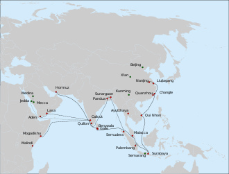
| Description | Deutsch: Route der 7. Expedition der Schatzschiffe von Zheng He (1431-1433).
English: Route of the 7th expedition of Zheng He's fleet (1431-1433).
Русский: Маршрут 7-го плавания китайского флота под общим командованием Чжэн Хэ и Ван Цзинхуна (1431-1433 гг).
|
| Date | |
| Source | Own work |
| Author | Vmenkov, based on the blank map File:Asie.svg (ver. 1) by User:Historicair |
| References | The main source for all routes: chapter on the last expedition of Zheng He in: Dreyer E. L., Zheng He: China and the Oceans in the Early Ming Dynasty, 1405-1433. — Longman, 2007. — 256 p. — (Library of World Biography Series). — ISBN 0321084438. The cities in Bengal are given as per : Barbosa, Duarte & Dames, Mansel Longworth (1996), An Account Of The Countries Bordering On The Indian Ocean And Their Inhabitants; Written By Duarte Barbosa And Completed About The Year 1518 A.D. Vol I: Including The Coasts Of East Africa, Arabia, Persia And Western India As Far As The Kingdom Of Vijayanagar. Vol. II: Including The Coasts Of Malabar, Eastern India, Further India, China And The Indian Archipelago. Asian Educational Services, pp. 138-139, ISBN 8120604512 |
| Other versions | []
|


Licensing
I, the copyright holder of this work, hereby publish it under the following licenses:
This file is licensed under the Creative Commons Attribution 1.0 Generic license.
- You are free:
- to share – to copy, distribute and transmit the work
- to remix – to adapt the work
- Under the following conditions:
- attribution – You must give appropriate credit, provide a link to the license, and indicate if changes were made. You may do so in any reasonable manner, but not in any way that suggests the licensor endorses you or your use.
This file is licensed under the Creative Commons Attribution-Share Alike 3.0 Unported license.
- You are free:
- to share – to copy, distribute and transmit the work
- to remix – to adapt the work
- Under the following conditions:
- attribution – You must give appropriate credit, provide a link to the license, and indicate if changes were made. You may do so in any reasonable manner, but not in any way that suggests the licensor endorses you or your use.
- share alike – If you remix, transform, or build upon the material, you must distribute your contributions under the same or compatible license as the original.
 | Permission is granted to copy, distribute and/or modify this document under the terms of the GNU Free Documentation License, Version 1.2 or any later version published by the Free Software Foundation; with no Invariant Sections, no Front-Cover Texts, and no Back-Cover Texts. A copy of the license is included in the section entitled GNU Free Documentation License. |
You may select the license of your choice.
File history
Click on a date/time to view the file as it appeared at that time.
| Date/Time | Thumbnail | Dimensions | User | Comment | |
|---|---|---|---|---|---|
| current | 01:41, 1 October 2019 | | 1,100 × 837 (599 KB) | Nancystodd | Corrected misplacement of map background. |
| 08:51, 24 August 2010 |  | 1,100 × 837 (839 KB) | Vmenkov | {{Information |Description={{en|1=Route of the 7th expedition of Zheng He's fleet (1431-1433). * Solid line: the route of the main fleet from Nanjing to Hormuz, as described in ''Xia Xiyang'' (下西洋). * Dashed line: a possible route of Hong Bao's sq |
File usage
The following page uses this file:
Global file usage
The following other wikis use this file:
- Usage on az.wikipedia.org
- Usage on bn.wikipedia.org
- Usage on bs.wikipedia.org
- Usage on de.wikipedia.org
- Usage on en.wikipedia.org
- Usage on es.wikipedia.org
- Usage on fr.wikipedia.org
- Usage on id.wikipedia.org
- Usage on it.wikipedia.org
- Usage on ka.wikipedia.org
- Usage on lij.wikipedia.org
- Usage on map-bms.wikipedia.org
- Usage on ml.wikipedia.org
- Usage on nds.wikipedia.org
- Usage on pl.wikipedia.org
- Usage on pnb.wikipedia.org
- Usage on sh.wikipedia.org
- Usage on sq.wikipedia.org
- Usage on su.wikipedia.org
- Usage on ur.wikipedia.org
- Usage on vi.wikipedia.org
- Usage on www.wikidata.org
- Usage on zh-yue.wikipedia.org
- Usage on zh.wikipedia.org
Metadata
Explore the world

United states
New York

Japan
Tokyo

Singapore
Singapore
