
 Français
 Italiano
Size of this preview: 693 × 600 pixels. Other resolutions: 277 × 240 pixels | 555 × 480 pixels | 888 × 768 pixels | 1,181 × 1,022 pixels.
Original file (1,181 × 1,022 pixels, file size: 451 KB, MIME type: image/jpeg)
This is a file from the Wikimedia Commons and may be used by other projects. Information from its description page there is shown below. Commons is a freely licensed media file repository. |
Summary
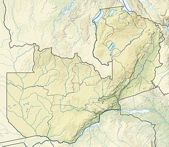
| Description | Español: Mapa de localización de Zambia Deutsch: Positionskarte von Sambia Quadratische Plattkarte, N-S-Streckung 103 %. Geographische Begrenzung der Karte:
English: Location map of Zambia Equirectangular projection, N/S stretching 103 %. Geographic limits of the map:
|
| Date | |
| Source | This file was derived from: |
| Author |
|
Licensing
This file is licensed under the Creative Commons Attribution-Share Alike 3.0 Unported license.
- You are free:
- to share – to copy, distribute and transmit the work
- to remix – to adapt the work
- Under the following conditions:
- attribution – You must give appropriate credit, provide a link to the license, and indicate if changes were made. You may do so in any reasonable manner, but not in any way that suggests the licensor endorses you or your use.
- share alike – If you remix, transform, or build upon the material, you must distribute your contributions under the same or compatible license as the original.
File history
Click on a date/time to view the file as it appeared at that time.
| Date/Time | Thumbnail | Dimensions | User | Comment | |
|---|---|---|---|---|---|
| current | 21:24, 20 January 2015 | | 1,181 × 1,022 (451 KB) | Milenioscuro | some missing elements |
| 20:52, 16 January 2015 |  | 1,181 × 1,022 (440 KB) | Milenioscuro | shadow of the country | |
| 20:52, 16 January 2015 |  | 1,181 × 1,022 (495 KB) | Milenioscuro | {{Information |Description ={{es|1=Mapa de localización de Zambia}} |Source =File:Zambezi river basin-fr.svg |Author =Shadowxfox |Date =2015-01-15 |Permission = |other_versions = }} |
File usage
There are no pages that use this file.
Global file usage
The following other wikis use this file:
- Usage on ast.wikipedia.org
- Usage on azb.wikipedia.org
- Usage on az.wikipedia.org
- Usage on ban.wikipedia.org
- Usage on be.wikipedia.org
- Usage on bg.wikipedia.org
View more global usage of this file.
Metadata
Explore the world

United states
New York

Japan
Tokyo

Singapore
Singapore
