
 Français
 Italiano
Size of this preview: 474 × 600 pixels. Other resolutions: 190 × 240 pixels | 379 × 480 pixels | 607 × 768 pixels | 1,114 × 1,409 pixels.
Original file (1,114 × 1,409 pixels, file size: 990 KB, MIME type: image/png)
This is a file from the Wikimedia Commons and may be used by other projects. Information from its description page there is shown below. Commons is a freely licensed media file repository. |
Summary
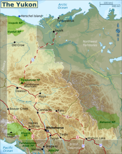
| Description | English: Map of the Yukon. Map is equirectangular projection, N/S stretching 200%. Geographic limits of the map:
Source data for map:
Note: ETOPO1 and Natural Earth are in the public domain. Data from BC and the Yukon are available under the Open Government Licence. Data from GeoBase and the Government of Canada are available under an Unrestricted Use Licence. Details of each licence are available on the organization's website., Yukon Territory
|
| Date | |
| Source | Own work, using various sources (see Description box) |
| Author | (WT-shared) Shaund |
Licensing
This file is licensed under the Creative Commons Attribution-Share Alike 3.0 Unported license.
- You are free:
- to share – to copy, distribute and transmit the work
- to remix – to adapt the work
- Under the following conditions:
- attribution – You must give appropriate credit, provide a link to the license, and indicate if changes were made. You may do so in any reasonable manner, but not in any way that suggests the licensor endorses you or your use.
- share alike – If you remix, transform, or build upon the material, you must distribute your contributions under the same or compatible license as the original.
Original upload log
| This file was imported from Wikivoyage WTS. |
The original description page was here. All following user names refer to wts.wikivoyage-old.
- 2012-07-19 13:35 (WT-shared) Shaund archive copy at the Wayback Machine 742×940 (629873 bytes) {{Imagecredit|credit=[[User:Shaund|Shaund]]|captureDate=18 July 2012|location=Yukon Territory|source=Own work, using various sources (see De (Import from wikitravel.org/shared)
- 2012-07-24 04:01 (WT-shared) Shaund archive copy at the Wayback Machine 1114×1409 (1014062 bytes) add missing icons, highway numbers, scale, north arrow, WT style (Import from wikitravel.org/shared)
File history
Click on a date/time to view the file as it appeared at that time.
| Date/Time | Thumbnail | Dimensions | User | Comment | |
|---|---|---|---|---|---|
| current | 04:00, 18 December 2012 | | 1,114 × 1,409 (990 KB) | OgreBot | (BOT): Reverting to most recent version before archival |
| 04:00, 18 December 2012 |  | 742 × 940 (615 KB) | OgreBot | (BOT): Uploading old version of file from wts.wikivoyage; originally uploaded on 2012-07-19 13:35:13 by (WT-shared) Shaund | |
| 03:31, 18 November 2012 |  | 1,114 × 1,409 (990 KB) | MGA73bot2 | {{BotMoveToCommons|wts.oldwikivoyage|year={{subst:CURRENTYEAR}}|month={{subst:CURRENTMONTHNAME}}|day={{subst:CURRENTDAY}}}} == {{int:filedesc}} == {{Information |description=Map of the Yukon. Map is equirectangular projection, N/S stretching 200%. Geog... |
File usage
The following 3 pages use this file:
Global file usage
The following other wikis use this file:
- Usage on de.wikipedia.org
- Usage on it.wikivoyage.org
- Usage on nl.wikivoyage.org
- Usage on pt.wikipedia.org
- Usage on tt.wikipedia.org
- Usage on www.wikidata.org
Metadata
Explore the world

United states
New York

Japan
Tokyo

Singapore
Singapore
