
 Français
 Italiano
Size of this PNG preview of this SVG file: 531 × 600 pixels. Other resolutions: 212 × 240 pixels | 425 × 480 pixels | 680 × 768 pixels | 907 × 1,024 pixels | 1,813 × 2,048 pixels | 1,082 × 1,222 pixels.
Original file (SVG file, nominally 1,082 × 1,222 pixels, file size: 146 KB)
This is a file from the Wikimedia Commons and may be used by other projects. Information from its description page there is shown below. Commons is a freely licensed media file repository. |
Summary
| Camera location | | View this and other nearby images on: OpenStreetMap |
|---|
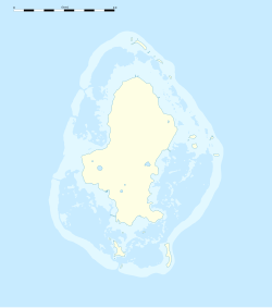
| Description | English: Blank administrative map of Wallis Island, part of the French overseas collectivity of Wallis and Futuna, for geo-location purpose. Français : Carte administrative vierge de Wallis de la Collectivité d'outre-mer de Wallis-et-Futuna, destinée à la géolocalisation. Scale: 1:372,000 (precision: 93 m)
Geographic limits of the map:
| ||
| Date | |||
| Source | Own work
| ||
| Author | Eric Gaba (Sting - fr:Sting) | ||
| Permission (Reusing this file) |
| ||
| Other versions |
See also:
|


Licensing
Eric Gaba, Wikimedia Commons user Sting, the copyright holder of this work, hereby publishes it under the following license:
This file is licensed under the Creative Commons Attribution-Share Alike 3.0 Unported license.
Attribution: Eric Gaba, Wikimedia Commons user Sting
- You are free:
- to share – to copy, distribute and transmit the work
- to remix – to adapt the work
- Under the following conditions:
- attribution – You must give appropriate credit, provide a link to the license, and indicate if changes were made. You may do so in any reasonable manner, but not in any way that suggests the licensor endorses you or your use.
- share alike – If you remix, transform, or build upon the material, you must distribute your contributions under the same or compatible license as the original.
File history
Click on a date/time to view the file as it appeared at that time.
| Date/Time | Thumbnail | Dimensions | User | Comment | |
|---|---|---|---|---|---|
| current | 02:24, 11 July 2010 | | 1,082 × 1,222 (146 KB) | Sting | Simplifying reef color scheme |
| 22:09, 10 July 2010 |  | 1,082 × 1,222 (147 KB) | Sting | == {{int:filedesc}} == {{Location|13|17|15|S|176|12|00|W|scale:100000}} <br/> {{Information |Description={{en|Blank administrative map of Wallis Island, part of the French overseas collectivity of |
File usage
There are no pages that use this file.
Global file usage
The following other wikis use this file:
- Usage on ar.wikipedia.org
- Usage on be-tarask.wikipedia.org
- Usage on bn.wikipedia.org
- Usage on ceb.wikipedia.org
- Usage on de.wikipedia.org
- Mata Utu
- Wikipedia:Kartenwerkstatt/Positionskarten/Australien und Ozeanien
- Vorlage:Positionskarte Wallis-Inseln
- Flughafen Wallis-Hihifo
- Vorlage:Positionskarte Wallis
- Vaitupu (Wallis und Futuna)
- Alele
- Malaʻe (Uvea)
- Vailala
- Tufuʻone
- Liku (Wallis und Futuna)
- Falaleu
- Akaʻaka
- Ahoa
- Haʻafuasia
- Malaʻefoʻou
- Utufua
- Halalo
- Vaimalau
- Lavegahau
- Teʻesi
- Gahi
- Haʻatofo
- Tepa (Wallis und Futuna)
- Kolopopo
- Usage on el.wikipedia.org
- Usage on en.wikipedia.org
View more global usage of this file.
Metadata
Explore the world

United states
New York

Japan
Tokyo

Singapore
Singapore
