
 Français
 Italiano
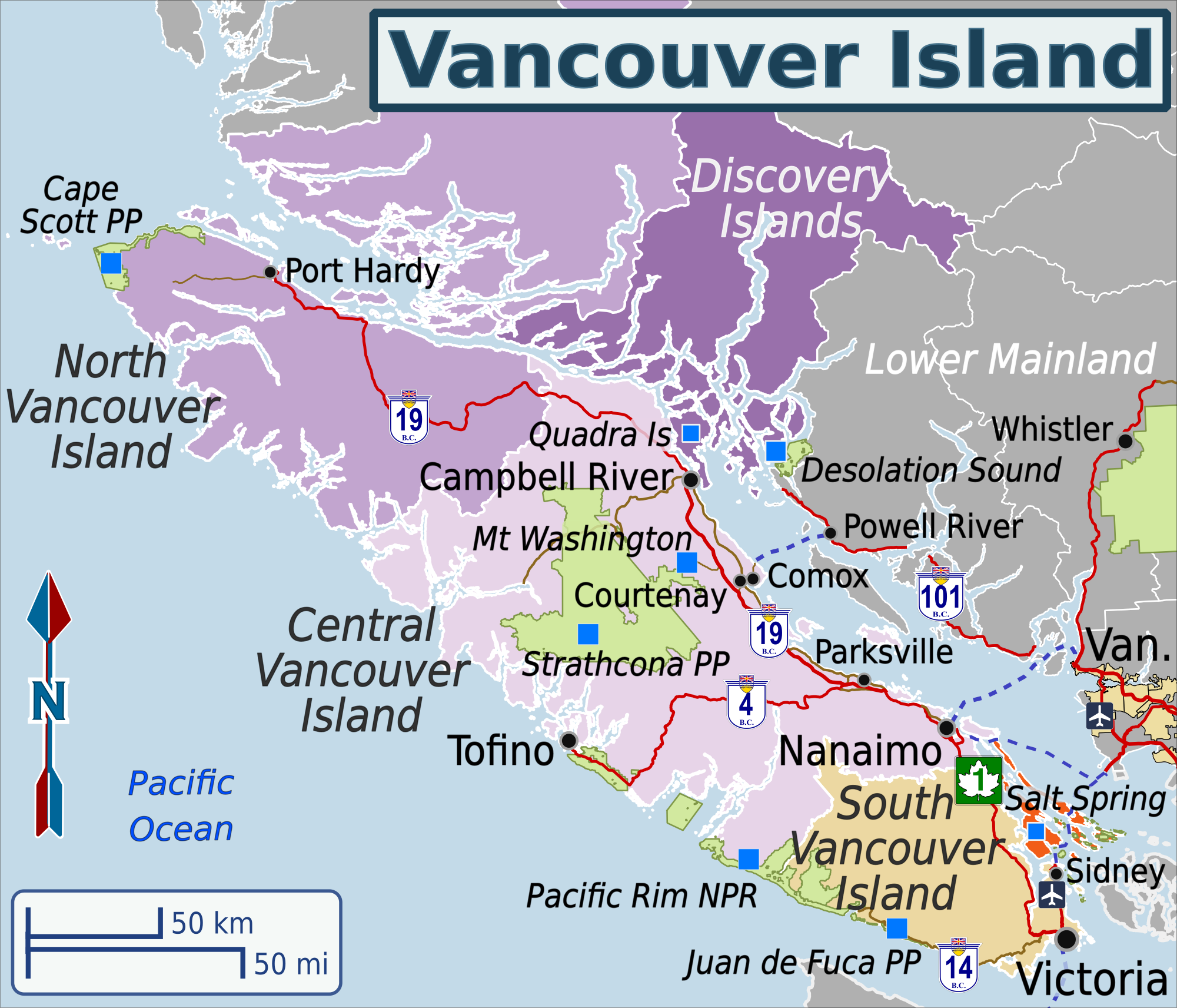
Size of this preview: 700 × 599 pixels. Other resolutions: 280 × 240 pixels | 561 × 480 pixels | 897 × 768 pixels | 1,196 × 1,024 pixels | 2,000 × 1,712 pixels.
Original file (2,000 × 1,712 pixels, file size: 1.13 MB, MIME type: image/png)
This is a file from the Wikimedia Commons and may be used by other projects. Information from its description page there is shown below. Commons is a freely licensed media file repository. |
Summary
| Description | English: Wikivoyage-style map depicting Vancouver Island's travel regions, main roads and destinations. Map projection is BC Albers; scale is 1:2,200,000. |
| Date | (updated 11 Aug 2018) |
| Source | Own work, based on the following data sources:
Note: Data from the BC government is available under the Open Government Licence. Data from Stats Can is available under the Statistics Canada Open Licence Agreement. OSM map tiles are licensed under CC-BY-SA 2.0. Natural Earth data is in the public domain. Details of each licence are available on the organization's website. Colour scheme adapted from ColorBrewer 2.0 |
| Author | Shaundd |
Licensing
I, the copyright holder of this work, hereby publish it under the following license:
This file is licensed under the Creative Commons Attribution-Share Alike 4.0 International license.
- You are free:
- to share – to copy, distribute and transmit the work
- to remix – to adapt the work
- Under the following conditions:
- attribution – You must give appropriate credit, provide a link to the license, and indicate if changes were made. You may do so in any reasonable manner, but not in any way that suggests the licensor endorses you or your use.
- share alike – If you remix, transform, or build upon the material, you must distribute your contributions under the same or compatible license as the original.
File history
Click on a date/time to view the file as it appeared at that time.
| Date/Time | Thumbnail | Dimensions | User | Comment | |
|---|---|---|---|---|---|
| current | 06:24, 12 August 2018 | | 2,000 × 1,712 (1.13 MB) | Shaundd | more subdued colour scheme, add ferries, change some text to improve readability |
| 05:06, 30 May 2017 |  | 2,000 × 1,712 (1.02 MB) | Shaundd | added region names, adjusted city labels, added highway shields and other edits to improve readabiity | |
| 05:03, 9 April 2017 |  | 1,590 × 1,361 (608 KB) | Shaundd | User created page with UploadWizard |
File usage
The following 3 pages use this file:
Global file usage
The following other wikis use this file:
- Usage on it.wikivoyage.org
Metadata
Explore the world

United states
New York

Japan
Tokyo

Singapore
Singapore
