
 Français
 Italiano
Size of this preview: 800 × 550 pixels. Other resolutions: 320 × 220 pixels | 640 × 440 pixels | 1,000 × 687 pixels.
Original file (1,000 × 687 pixels, file size: 200 KB, MIME type: image/png)
This is a file from the Wikimedia Commons and may be used by other projects. Information from its description page there is shown below. Commons is a freely licensed media file repository. |
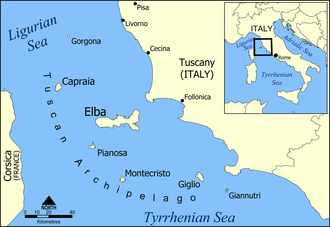
| Description | A map of the Tuscan archipelago, including the islands Elba, Capraia, Giglio, Montecristo, Pianosa, Gorgona, and Giannutri. Tyrrhenian Sea. |
| Date | |
| Source | Own work |
| Author | Created by NormanEinstein |
| Other versions | A blank version of this map is available at: Image:Tuscan archipelago blank map.png |
I, the copyright holder of this work, hereby publish it under the following licenses:
 | Permission is granted to copy, distribute and/or modify this document under the terms of the GNU Free Documentation License, Version 1.2 or any later version published by the Free Software Foundation; with no Invariant Sections, no Front-Cover Texts, and no Back-Cover Texts. A copy of the license is included in the section entitled GNU Free Documentation License. |
| This file is licensed under the Creative Commons Attribution-Share Alike 3.0 Unported license. | ||
| ||
| This licensing tag was added to this file as part of the GFDL licensing update. |
You may select the license of your choice.
File history
Click on a date/time to view the file as it appeared at that time.
| Date/Time | Thumbnail | Dimensions | User | Comment | |
|---|---|---|---|---|---|
| current | 19:32, 12 July 2006 | | 1,000 × 687 (200 KB) | NormanEinstein | Corrected typo. |
| 19:06, 19 December 2005 |  | 1,000 × 688 (258 KB) | NormanEinstein | Corrected typo. | |
| 15:46, 20 May 2005 |  | 800 × 550 (195 KB) | NormanEinstein | Slightly modified version with brighter colours. | |
| 10:42, 20 May 2005 |  | 1,000 × 687 (238 KB) | Airunp | From en:Image:Tuscan archipelago.png A map of the Tuscan archipelago, including the islands Elba, Capraia, Giglio, Montecristo, Pianosa, Gorgona, and Giannotri. I made this. {{PD-self}} Category:France Category:Maps |
File usage
There are no pages that use this file.
Global file usage
The following other wikis use this file:
- Usage on af.wikipedia.org
- Usage on als.wikipedia.org
- Usage on ar.wikipedia.org
- Usage on arz.wikipedia.org
- Usage on azb.wikipedia.org
- Usage on az.wikipedia.org
- Usage on be.wikipedia.org
- Usage on bn.wikipedia.org
- Usage on br.wikipedia.org
- Usage on bs.wikipedia.org
- Usage on ca.wikipedia.org
- Usage on ceb.wikipedia.org
- Usage on ckb.wikipedia.org
- Usage on cs.wikipedia.org
- Usage on cy.wikipedia.org
- Usage on da.wikipedia.org
- Usage on de.wikipedia.org
View more global usage of this file.
Metadata
Explore the world

United states
New York

Japan
Tokyo

Singapore
Singapore
