
 Français
 Italiano
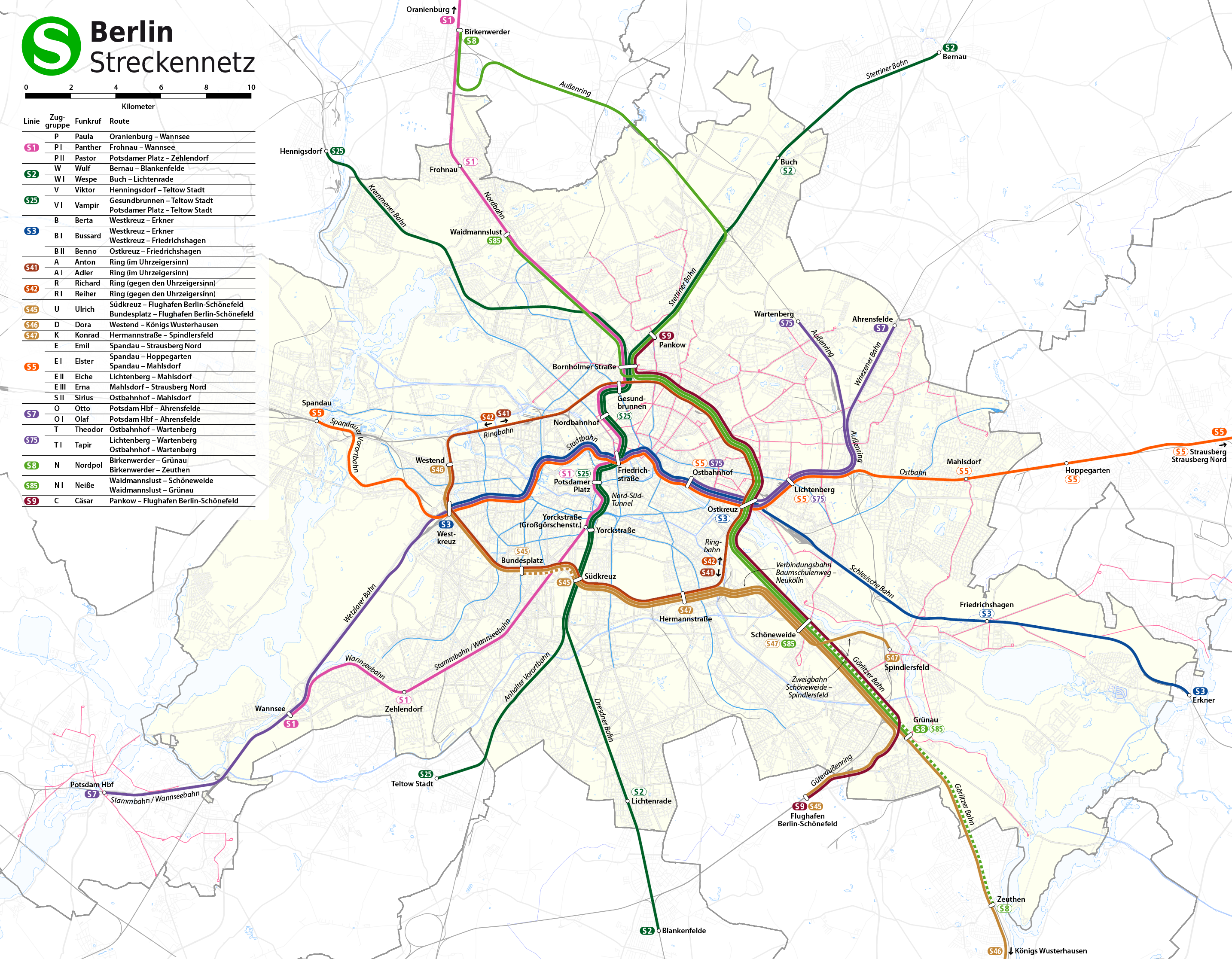
Size of this preview: 770 × 600 pixels. Other resolutions: 308 × 240 pixels | 617 × 480 pixels | 987 × 768 pixels | 1,280 × 997 pixels | 2,560 × 1,993 pixels | 2,868 × 2,233 pixels.
Original file (2,868 × 2,233 pixels, file size: 3.45 MB, MIME type: image/png)
This is a file from the Wikimedia Commons and may be used by other projects. Information from its description page there is shown below. Commons is a freely licensed media file repository. |
 | File:S-Bahn-Linien Berlin.svg is a vector version of this file. Error: No SVG image by that name exists. Please make sure to use the correct format: {{Vector version available|new image name}}. File:Topographischer Netzplan der S-Bahn Berlin.png → File:S-Bahn-Linien Berlin.svg For more information, see Help:SVG. |
| Description | Deutsch: Geographischer Netzplan der S-Bahn Berlin English: Geographical network map of the Berlin S-Bahn |
| Date | see file history |
| Source | own work, using
|
| Author | Maximilian Dörrbecker (Chumwa) |
| Permission (Reusing this file) | All OpenStreetMap data and maps are Creative Commons "CC-BY-SA 2.0" licensed This file is licensed under the Creative Commons Attribution-Share Alike 2.0 Generic license.
|
| Other versions | |


File history
Click on a date/time to view the file as it appeared at that time.
| Date/Time | Thumbnail | Dimensions | User | Comment | |
|---|---|---|---|---|---|
| current | 20:01, 21 August 2017 | | 2,868 × 2,233 (3.45 MB) | Chumwa | Aktualisierung |
| 05:50, 21 August 2017 |  | 2,868 × 2,233 (3.45 MB) | Chumwa | corr | |
| 22:11, 28 December 2011 |  | 2,065 × 1,608 (2.12 MB) | Chumwa | Zuggruppenliste und Maßstabsleiste hinzugefügt | |
| 06:42, 17 December 2011 |  | 2,065 × 1,608 (2.08 MB) | Chumwa | Fahrplanwechsel Dez. 2011 | |
| 06:51, 22 October 2011 |  | 2,065 × 1,608 (2.08 MB) | Chumwa | S5 nur bis Westkreuz | |
| 21:22, 23 March 2011 |  | 2,065 × 1,608 (2.09 MB) | Chumwa | corr | |
| 22:30, 14 December 2010 |  | 2,065 × 1,608 (2.1 MB) | Chumwa | Aktualisierung | |
| 09:32, 4 October 2009 |  | 2,065 × 1,562 (2.07 MB) | Chumwa | Lage der Bahnhöfe Spandau und Hermannstraße korrigiert | |
| 19:59, 28 September 2009 |  | 2,065 × 1,562 (2.07 MB) | Chumwa | Henningsdorf → Henigsdorf, Kemmener Bahn → Kremmener Bahn | |
| 05:25, 28 September 2009 |  | 2,065 × 1,562 (2.07 MB) | Chumwa | U-Bahn im Bereich Prenzlauer Berg an die Oberfläche geholt, U55 nachgetragen |
File usage
The following page uses this file:
Global file usage
The following other wikis use this file:
- Usage on de.wikipedia.org
- Usage on eo.wikipedia.org
- Usage on fa.wikivoyage.org
- Usage on incubator.wikimedia.org
- Usage on ko.wikipedia.org
- Usage on nl.wikivoyage.org
- Usage on ru.wikipedia.org
- Usage on uk.wikipedia.org
Metadata
Explore the world

United states
New York

Japan
Tokyo

Singapore
Singapore
