
 Français
 Italiano
Size of this PNG preview of this SVG file: 525 × 600 pixels. Other resolutions: 210 × 240 pixels | 420 × 480 pixels | 672 × 768 pixels | 896 × 1,024 pixels | 1,792 × 2,048 pixels | 721 × 824 pixels.
Original file (SVG file, nominally 721 × 824 pixels, file size: 107 KB)
This is a file from the Wikimedia Commons and may be used by other projects. Information from its description page there is shown below. Commons is a freely licensed media file repository. |
Summary
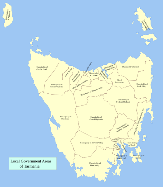
Local Government Areas of Tasmania. Reference: Local Government Publications
This W3C-unspecified vector image was created with Inkscape .
Licensing
I, the copyright holder of this work, hereby publish it under the following license:
 | Permission is granted to copy, distribute and/or modify this document under the terms of the GNU Free Documentation License, Version 1.2 or any later version published by the Free Software Foundation; with no Invariant Sections, no Front-Cover Texts, and no Back-Cover Texts. A copy of the license is included in the section entitled GNU Free Documentation License. |
| This file is licensed under the Creative Commons Attribution-Share Alike 3.0 Unported license. | ||
| ||
| This licensing tag was added to this file as part of the GFDL licensing update. |
File history
Click on a date/time to view the file as it appeared at that time.
| Date/Time | Thumbnail | Dimensions | User | Comment | |
|---|---|---|---|---|---|
| current | 08:43, 8 March 2007 | | 721 × 824 (107 KB) | Roke~commonswiki | Local Government Areas of New South Wales. Reference: [http://www.dotars.gov.au/local/publications/index.aspx Local Government Publications] {{Aus LGA maps}} {{inkscape}} [[Category:Maps of Local Government Area |
File usage
The following page uses this file:
Global file usage
The following other wikis use this file:
- Usage on de.wikipedia.org
- Usage on en.wikipedia.org
- Usage on fi.wikipedia.org
- Usage on frr.wikipedia.org
- Usage on fr.wikipedia.org
- Usage on id.wikipedia.org
- Usage on it.wikipedia.org
- Usage on ja.wikipedia.org
- Usage on nl.wikipedia.org
- Usage on pl.wikipedia.org
- Usage on pt.wikipedia.org
- Usage on ru.wikipedia.org
- Usage on ta.wikipedia.org
- Usage on uk.wikipedia.org
- Usage on zh.wikipedia.org
Explore the world

United states
New York

Japan
Tokyo

Singapore
Singapore
