
 Français
 Italiano
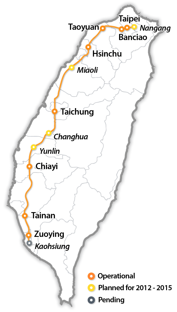
Size of this preview: 341 × 600 pixels. Other resolutions: 136 × 240 pixels | 602 × 1,059 pixels.
Original file (602 × 1,059 pixels, file size: 68 KB, MIME type: image/gif)
This is a file from the Wikimedia Commons and may be used by other projects. Information from its description page there is shown below. Commons is a freely licensed media file repository. |
| Description | Taiwan High Speed Rail Route Map (English) | ||
| Date | |||
| Source | Chinese version of the Route Map in Wikimedia | ||
| Author | Komatta | ||
| Permission (Reusing this file) |
|
File history
Click on a date/time to view the file as it appeared at that time.
| Date/Time | Thumbnail | Dimensions | User | Comment | |
|---|---|---|---|---|---|
| current | 12:10, 11 October 2010 | | 602 × 1,059 (68 KB) | Komatta | Updated with the latest info for planned stations. Individually, Nangang is 2012, Miaoli and Changhua are 2014, and Yunlin is 2015. |
| 14:06, 11 February 2007 |  | 602 × 1,059 (72 KB) | Komatta | ||
| 05:03, 23 January 2007 |  | 617 × 1,059 (82 KB) | Jpatokal | Fixed misleading label --jpatokal | |
| 06:33, 13 January 2007 |  | 617 × 1,059 (57 KB) | Komatta | ||
| 06:25, 13 January 2007 |  | 600 × 1,059 (58 KB) | Komatta | == ファイルの概要 == {{Information |Description=Taiwan High Speed Rail Route Map |Source=Chinese version of the Route Map in Wikimedia |Date=Jan 13, 2007 |Author=Komatta |Permission={{PD-user-w|en|Wikipedia|Komatta}} |other_versions= }} [[Category |
File usage
There are no pages that use this file.
Global file usage
The following other wikis use this file:
- Usage on es.wikipedia.org
- Usage on fa.wikipedia.org
- Usage on fi.wikivoyage.org
- Usage on fr.wikipedia.org
- Usage on he.wikivoyage.org
- Usage on hu.wikipedia.org
- Usage on it.wikipedia.org
- Usage on no.wikipedia.org
- Usage on sv.wikipedia.org
- Usage on sv.wikivoyage.org
- Usage on www.wikidata.org
- Usage on zh.wikipedia.org
Explore the world

United states
New York

Japan
Tokyo

Singapore
Singapore
