
 Français
 Italiano
Size of this preview: 579 × 600 pixels. Other resolutions: 232 × 240 pixels | 463 × 480 pixels | 741 × 768 pixels | 1,224 × 1,268 pixels.
Original file (1,224 × 1,268 pixels, file size: 212 KB, MIME type: image/png)
This is a file from the Wikimedia Commons and may be used by other projects. Information from its description page there is shown below. Commons is a freely licensed media file repository. |
Summary
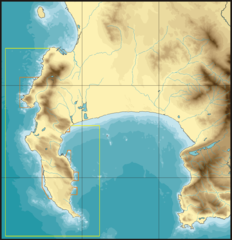
| Description | Boundaries of the Table Mountain National Park Marine Protected Area.
|
| Date | |
| Source | P.B.Southwood |
| Author | Peter Southwood |
Licensing
User: (WT-shared) Pbsouthwood at wts wikivoyage, the copyright holder of this work, hereby publishes it under the following license:
This file is licensed under the Creative Commons Attribution-Share Alike 3.0 Unported license.
Attribution: User: (WT-shared) Pbsouthwood at wts wikivoyage
- You are free:
- to share – to copy, distribute and transmit the work
- to remix – to adapt the work
- Under the following conditions:
- attribution – You must give appropriate credit, provide a link to the license, and indicate if changes were made. You may do so in any reasonable manner, but not in any way that suggests the licensor endorses you or your use.
- share alike – If you remix, transform, or build upon the material, you must distribute your contributions under the same or compatible license as the original.
Original upload log
| This file was imported from Wikivoyage WTS. |
The original description page was here. All following user names refer to wts.wikivoyage-old.
org:
- 2009-08-08 14:50 (WT-shared) Pbsouthwood[dead link] 1224×1268 (217030 bytes) {{Imagecredit|credit=Peter Southwood|captureDate=2009|location=Cape Town|source=P.B.Southwood|caption=Boundaries of the Table Mountain natio (Import from wikitravel.org/shared)
File history
Click on a date/time to view the file as it appeared at that time.
| Date/Time | Thumbnail | Dimensions | User | Comment | |
|---|---|---|---|---|---|
| current | 19:33, 15 November 2012 | | 1,224 × 1,268 (212 KB) | MGA73bot2 | {{BotMoveToCommons|wts.oldwikivoyage|year={{subst:CURRENTYEAR}}|month={{subst:CURRENTMONTHNAME}}|day={{subst:CURRENTDAY}}}} == {{int:filedesc}} == {{Information |description=Boundaries of the Table Mountain national Park Marine Protected Area. Map show... |
File usage
The following 4 pages use this file:
Global file usage
The following other wikis use this file:
- Usage on en.wikipedia.org
Explore the world

United states
New York

Japan
Tokyo

Singapore
Singapore
