
 Français
 Italiano
Size of this preview: 800 × 513 pixels. Other resolutions: 320 × 205 pixels | 640 × 410 pixels | 1,024 × 657 pixels | 1,349 × 865 pixels.
Original file (1,349 × 865 pixels, file size: 602 KB, MIME type: image/jpeg)
This is a file from the Wikimedia Commons and may be used by other projects. Information from its description page there is shown below. Commons is a freely licensed media file repository. |
Summary
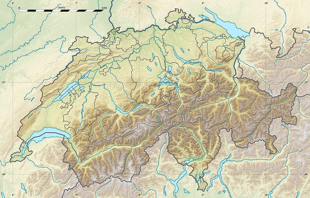
| Description | English: Blank physical map of Switzerland, for geo-location purpose. More maps: → Maps of Switzerland. Français : Carte physique vierge de la Suisse, destinée à la géolocalisation. Equirectangular projection, WGS84 datum
Geographic limits of the map:
| ||
| Date | |||
| Source |
| ||
| Author | Eric Gaba (Sting - fr:Sting) and NordNordWest | ||
| Permission (Reusing this file) |
| ||
| Other versions | Derivative works of this file: WW2 Dispositif Limmat map.jpg
|

_location_map.svg)
| Camera location | | View this and other nearby images on: OpenStreetMap |
|---|
 | This map has been made or improved in the German Kartenwerkstatt (Map Lab). You can propose maps to improve as well. |
Licensing
I, the copyright holder of this work, hereby publish it under the following license:
This file is licensed under the Creative Commons Attribution-Share Alike 3.0 Unported license.
- You are free:
- to share – to copy, distribute and transmit the work
- to remix – to adapt the work
- Under the following conditions:
- attribution – You must give appropriate credit, provide a link to the license, and indicate if changes were made. You may do so in any reasonable manner, but not in any way that suggests the licensor endorses you or your use.
- share alike – If you remix, transform, or build upon the material, you must distribute your contributions under the same or compatible license as the original.
gallery
fr:Modèle:Géolocalisation/Suisse
-
 relief
 -
 default
 -
 image1
 -
 image2
 -
 relief1
 -
 relief2
 -
 relief3


File history
Click on a date/time to view the file as it appeared at that time.
| Date/Time | Thumbnail | Dimensions | User | Comment | |
|---|---|---|---|---|---|
| current | 21:04, 17 December 2017 | | 1,349 × 865 (602 KB) | Reinhard Kraasch | Verlauf des Doubs korrigiert / Doubs River course retouched |
| 13:28, 19 July 2010 |  | 1,349 × 865 (439 KB) | Sting | Color profile | |
| 14:27, 4 December 2009 |  | 1,349 × 865 (456 KB) | Sting | == {{int:filedesc}} == {{Location|46|49|30|N|8|15|00|E|scale:1000000}} <br/> {{Information |Description={{de|Relief Positionskarte der Schweiz.}} {{en|Blank physical map of Switzerland, for geo-location purpose.}} {{fr| |
File usage
There are no pages that use this file.
Global file usage
The following other wikis use this file:
- Usage on als.wikipedia.org
- Langensee
- Gotthardpass
- Rheinwaldhorn
- Pfäffikersee
- Sarnersee
- Etzel (Berg)
- Höhronen (Berg)
- Sattel (Pass)
- Churfirsten
- Säntis
- Wohlensee
- Ruine Rifenstein
- Wartenberg (Muttenz)
- Lägern
- Schloss Lenzburg
- Uetliberg
- Schloss Chillon
- Schloss Bottmingen
- Schloss Pratteln
- Ruine Madeln
- Burg Kropfenstein
- Vorlage:Positionskarte Schweiz
- Schloss Klingnau
- Ruine Iberg
- Ruine Besserstein
- Rengg
- Schloss Rümligen
- Pilatus
- Festung Aarburg
- Dufourspitze
- Schloss Schwarzwasserstelz
- Schloss Stein
- Schloss Uster
- Stausee Wettingen
- Grosser St. Bernhard
- Malojapass
- Splügenpass
- Matterhorn
- Schwendisee
- Morgenberghorn
- Ruine Schenkenberg
- Schloss Auenstein
- Schloss Kasteln
- Siggenberg
- Chestenberg
- Bruggerberg
- Wartenberg-Ruinen
- Scheidegg (Tecknau)
- Ruine Münchenstein
- Ruine Farnsburg
View more global usage of this file.
Metadata
Explore the world

United states
New York

Japan
Tokyo

Singapore
Singapore
