
 Français
 Italiano
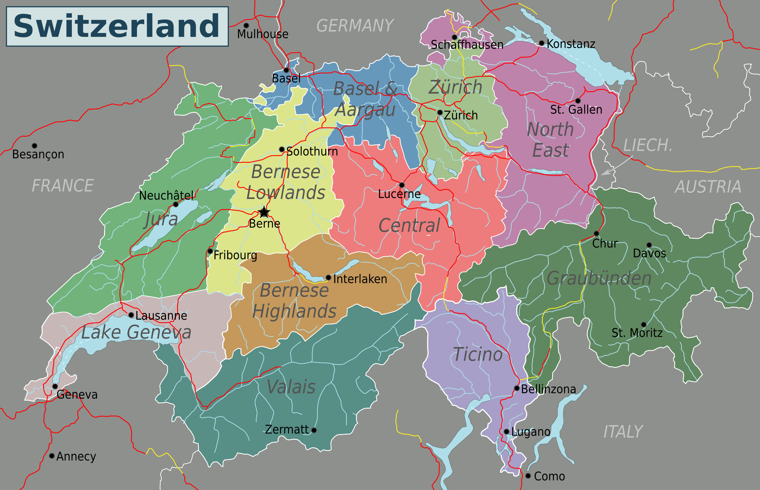
Size of this preview: 800 × 517 pixels. Other resolutions: 320 × 207 pixels | 640 × 413 pixels | 1,024 × 661 pixels | 1,280 × 827 pixels | 2,453 × 1,584 pixels.
Original file (2,453 × 1,584 pixels, file size: 1.07 MB, MIME type: image/png)
This is a file from the Wikimedia Commons and may be used by other projects. Information from its description page there is shown below. Commons is a freely licensed media file repository. |
Summary
| Description | English: Map of Switzerland (PNG). Nota Bene: the regions displayed in this map are not official administrative divisions. |
| Date | |
| Source | Own work based on Suisse cantons.svg by Pymouss44, Switzerland regions.svg by Stefan Ertmann and work by OpenStreetMap.org contributors. |
| Author | Globe-trotter |
| Other versions | Inkscape SVG |
Licensing
This file is licensed under the Creative Commons Attribution-Share Alike 4.0 International license.
- You are free:
- to share – to copy, distribute and transmit the work
- to remix – to adapt the work
- Under the following conditions:
- attribution – You must give appropriate credit, provide a link to the license, and indicate if changes were made. You may do so in any reasonable manner, but not in any way that suggests the licensor endorses you or your use.
- share alike – If you remix, transform, or build upon the material, you must distribute your contributions under the same or compatible license as the original.
File history
Click on a date/time to view the file as it appeared at that time.
| Date/Time | Thumbnail | Dimensions | User | Comment | |
|---|---|---|---|---|---|
| current | 05:40, 4 May 2016 | | 2,453 × 1,584 (1.07 MB) | Drat70 | Reverted to version as of 11:04, 16 May 2015 (UTC) as this file is also used by other pages |
| 05:38, 4 May 2016 |  | 2,462 × 1,590 (1.04 MB) | Drat70 | Changed some of the regions as per discussion on the wikivoyage Switzerland talk page. | |
| 11:04, 16 May 2015 |  | 2,453 × 1,584 (1.07 MB) | Globe-trotter | {{Information |description={{en|1=Map of Switzerland (PNG).}} {{Created with Inkscape|IMPORTANT=1}} |date=2015-05-16 |source={{own}} based on Suisse cantons.svg by Pymouss44, [[:File:Switzerland regions.s... |
File usage
The following 2 pages use this file:
Global file usage
The following other wikis use this file:
- Usage on fa.wikivoyage.org
- Usage on hi.wikibooks.org
Metadata
Explore the world

United states
New York

Japan
Tokyo

Singapore
Singapore
