
 Français
 Italiano
Size of this PNG preview of this SVG file: 511 × 599 pixels. Other resolutions: 205 × 240 pixels | 409 × 480 pixels | 655 × 768 pixels | 873 × 1,024 pixels | 1,747 × 2,048 pixels | 853 × 1,000 pixels.
Original file (SVG file, nominally 853 × 1,000 pixels, file size: 1.02 MB)
This is a file from the Wikimedia Commons and may be used by other projects. Information from its description page there is shown below. Commons is a freely licensed media file repository. |
Summary
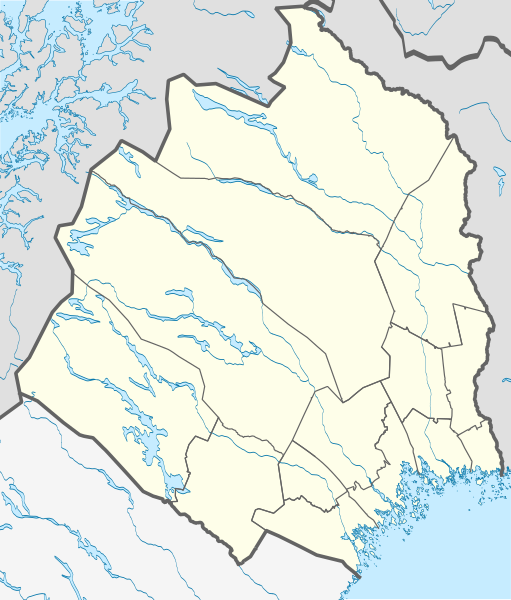
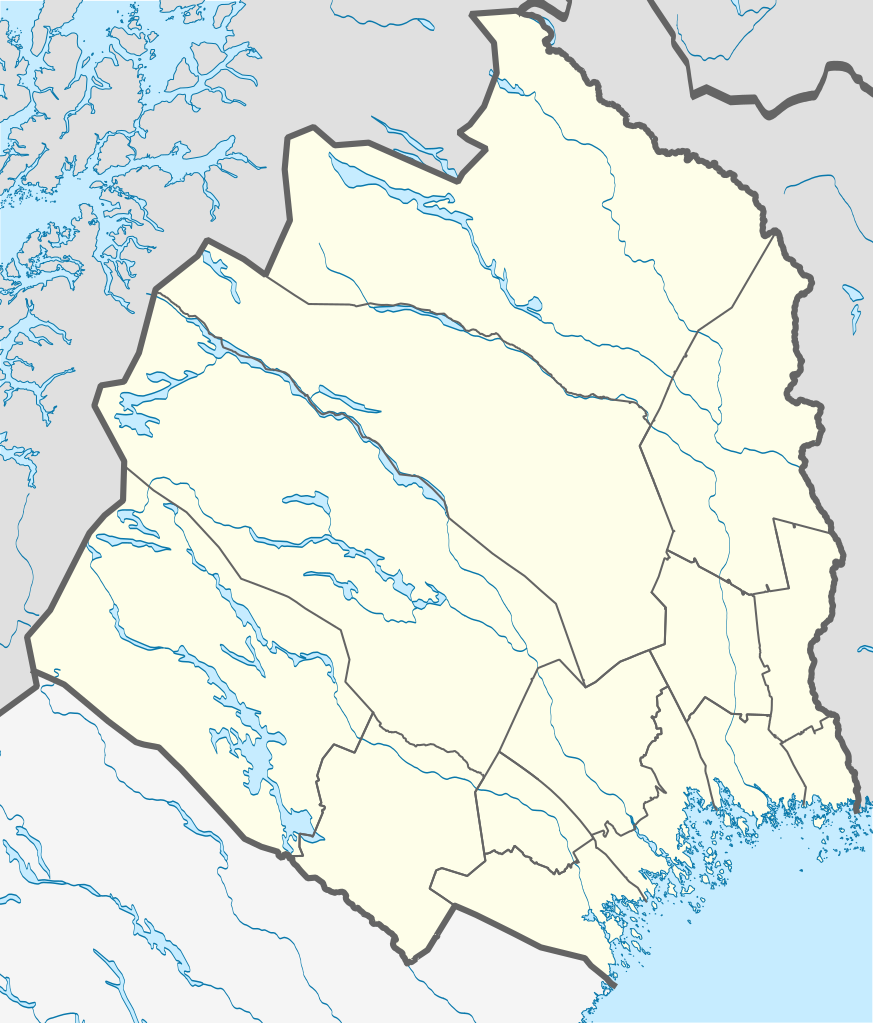
| Description | English: Location map of Norrbotten County in Sweden Equirectangular projection, N/S stretching 257 %. Geographic limits of the map:
Deutsch: Positionskarte von Norrbottens län in Schweden Quadratische Plattkarte, N-S-Streckung 257 %. Geographische Begrenzung der Karte:
|
| Date | |
| Source | Own work |
| Author | Erik Frohne |
Licensing
I, the copyright holder of this work, hereby publish it under the following licenses:
 | Permission is granted to copy, distribute and/or modify this document under the terms of the GNU Free Documentation License, Version 1.2 or any later version published by the Free Software Foundation; with no Invariant Sections, no Front-Cover Texts, and no Back-Cover Texts. A copy of the license is included in the section entitled GNU Free Documentation License. |
This file is licensed under the Creative Commons Attribution-Share Alike 3.0 Unported license.
- You are free:
- to share – to copy, distribute and transmit the work
- to remix – to adapt the work
- Under the following conditions:
- attribution – You must give appropriate credit, provide a link to the license, and indicate if changes were made. You may do so in any reasonable manner, but not in any way that suggests the licensor endorses you or your use.
- share alike – If you remix, transform, or build upon the material, you must distribute your contributions under the same or compatible license as the original.
You may select the license of your choice.
File history
Click on a date/time to view the file as it appeared at that time.
| Date/Time | Thumbnail | Dimensions | User | Comment | |
|---|---|---|---|---|---|
| current | 00:28, 23 April 2017 | | 853 × 1,000 (1.02 MB) | Silverkey | Complete redrawing (the previous version was horribly inaccurate) |
| 15:32, 2 March 2009 |  | 853 × 1,000 (572 KB) | Erik Frohne | {{Information |Description={{en|1=Location map of Norrbotten county in Sweden Equirectangular projection, N/S stretching 257 %. Geographic limits of the map: * N: 69.10° N * S: 64.90° N * W: 15.10° E * E: 24.30° E}} {{de|1=Positionskarte von Norrbot |
File usage
There are no pages that use this file.
Global file usage
The following other wikis use this file:
- Usage on ar.wikipedia.org
- Usage on bg.wikipedia.org
- Usage on ceb.wikipedia.org
- Usage on cs.wikipedia.org
- Usage on da.wikipedia.org
- Abisko
- Luleå
- Boden (Sverige)
- Abisko Nationalpark
- Gällivare
- Hortlax
- Malmberget
- Haparanda
- Piteå
- Flyulykken på Kebnekaise 2012
- Skabelon:Kortpositioner Sverige Norrbotten
- Björlings gletsjer
- Arjeplog
- Sikfors (Piteå kommun)
- Mellanström
- Slagnäs
- Sjulsmark (Piteå kommun)
- Strömsund (Luleå kommun)
- Råneå
- Nyborg (Sverige)
- Rolfs
- Påläng
View more global usage of this file.
Metadata
Explore the world

United states
New York

Japan
Tokyo

Singapore
Singapore
