
 Français
 Italiano
Size of this PNG preview of this SVG file: 426 × 599 pixels. Other resolutions: 170 × 240 pixels | 341 × 480 pixels | 546 × 768 pixels | 728 × 1,024 pixels | 1,456 × 2,048 pixels | 509 × 716 pixels.
Original file (SVG file, nominally 509 × 716 pixels, file size: 59 KB)
This is a file from the Wikimedia Commons and may be used by other projects. Information from its description page there is shown below. Commons is a freely licensed media file repository. |
Summary
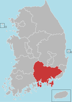
| Description | English: Locator map of South Gyeongsang |
| Date | |
| Source | File:Administrative divisions map of South Korea.svg (Dmthoth) |
| Author | Dmthoth |
Licensing
I, the copyright holder of this work, hereby publish it under the following licenses:
This file is licensed under the Creative Commons Attribution-Share Alike 3.0 Unported license.
- You are free:
- to share – to copy, distribute and transmit the work
- to remix – to adapt the work
- Under the following conditions:
- attribution – You must give appropriate credit, provide a link to the license, and indicate if changes were made. You may do so in any reasonable manner, but not in any way that suggests the licensor endorses you or your use.
- share alike – If you remix, transform, or build upon the material, you must distribute your contributions under the same or compatible license as the original.
 | Permission is granted to copy, distribute and/or modify this document under the terms of the GNU Free Documentation License, Version 1.2 or any later version published by the Free Software Foundation; with no Invariant Sections, no Front-Cover Texts, and no Back-Cover Texts. A copy of the license is included in the section entitled GNU Free Documentation License. |
You may select the license of your choice.
File history
Click on a date/time to view the file as it appeared at that time.
| Date/Time | Thumbnail | Dimensions | User | Comment | |
|---|---|---|---|---|---|
| current | 04:36, 4 July 2023 | | 509 × 716 (59 KB) | Nv7801 | First class administrative division change. |
| 11:02, 7 February 2013 |  | 509 × 716 (56 KB) | ASDFGH | == {{int:filedesc}} == {{Information |Description={{en|Locator map of South Gyeongsang}} |Source=File:Administrative divisions map of South Korea.svg (Dmthoth) |Author=Dmthoth |Date=2013-02-07 |Permission= |other_... |
File usage
The following page uses this file:
Global file usage
The following other wikis use this file:
- Usage on ar.wikipedia.org
- Usage on cdo.wikipedia.org
- Usage on cs.wikipedia.org
- Usage on en.wikipedia.org
- South Gyeongsang Province
- Jinhae District
- Changwon
- Geoje
- Gimhae
- Jinju
- Miryang
- Sacheon
- Tongyeong
- Yangsan
- Changnyeong County
- Geochang County
- Goseong County, South Gyeongsang
- Hadong County
- Haman County
- Hapcheon County
- Hamyang County
- Namhae County
- Sancheong County
- Uiryeong County
- Template:South Gyeongsang Province
- Uichang District
- Seongsan District
- Masanhoewon District
- Masanhappo District
- Hwawangsan
- User:Jsyjj92/sandbox
- User:Zsj.engl300/sandbox
- List of cities and counties of South Gyeongsang Province
- Usage on hak.wikipedia.org
View more global usage of this file.
Metadata
Explore the world

United states
New York

Japan
Tokyo

Singapore
Singapore
