
 Français
 Italiano
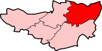
No higher resolution available.
SomersetMendip.png (200 × 101 pixels, file size: 6 KB, MIME type: image/png)
This is a file from the Wikimedia Commons and may be used by other projects. Information from its description page there is shown below. Commons is a freely licensed media file repository. |
Mendip in Somerset
Created by en:User:Morwen
 | Permission is granted to copy, distribute and/or modify this document under the terms of the GNU Free Documentation License, Version 1.2 or any later version published by the Free Software Foundation; with no Invariant Sections, no Front-Cover Texts, and no Back-Cover Texts. A copy of the license is included in the section entitled GNU Free Documentation License. |
| This file is licensed under the Creative Commons Attribution-Share Alike 3.0 Unported license. | ||
| ||
| This licensing tag was added to this file as part of the GFDL licensing update. |
File history
Click on a date/time to view the file as it appeared at that time.
| Date/Time | Thumbnail | Dimensions | User | Comment | |
|---|---|---|---|---|---|
| current | 13:56, 8 February 2010 | | 200 × 101 (6 KB) | Mahahahaneapneap | Transparent backround |
| 01:37, 10 September 2005 |  | 200 × 101 (10 KB) | Cnyborg | Menip in Somerset From en:Image:SomersetMendip.png by en:User:Morwen {{GFDL-en}} Category:Maps of English districts Category:Somerset |
File usage
There are no pages that use this file.
Global file usage
The following other wikis use this file:
- Usage on bg.wikipedia.org
- Usage on de.wikipedia.org
- Usage on en.wikipedia.org
- Wells, Somerset
- Glastonbury
- Shepton Mallet
- Street, Somerset
- Mendip District
- Frome
- Buckland Dinham
- Pilton, Somerset
- Batcombe, Somerset
- Chilcompton
- Coleford, Somerset
- Chewton Mendip
- Nunney
- Binegar
- Holcombe, Somerset
- Whatley, Mendip
- Ashwick
- St Cuthbert Out
- Baltonsborough
- Beckington
- Berkley, Somerset
- Witham Friary
- Kilmersdon
- Alhampton
- Rode, Somerset
- Litton, Somerset
- Mells, Somerset
- Norton St Philip
- Stratton-on-the-Fosse
- Westbury-sub-Mendip
- Priddy
- Rodney Stoke
- Ston Easton
- Cranmore, Somerset
- Croscombe
- Ditcheat
- Doulting
- Downhead
- East Pennard
- Emborough
- Evercreech
- Godney
- Great Elm
- Hemington, Somerset
- Lamyatt
- Lullington, Somerset
- Lydford-on-Fosse
- Meare
View more global usage of this file.
Explore the world

United states
New York

Japan
Tokyo

Singapore
Singapore
