
Original file (7,360 × 4,912 pixels, file size: 206.9 MB, MIME type: image/tiff)
![]() | This is a file from the Wikimedia Commons and may be used by other projects. Information from its description page there is shown below. Commons is a freely licensed media file repository. |
Summary
DescriptionSome of the buildings at Fort Brown in Brownsville, Texas LCCN2014630475.tif | English: Title: Some of the buildings at Fort Brown in Brownsville, Texas Physical description: 1 photograph : digital, tiff file, color. Notes: Title, date, and keywords based on information provided by the photographer.; Gift; The Lyda Hill Foundation; 2014; (DLC/PP-2014:054).; Forms part of: Lyda Hill Texas Collection of Photographs in Carol M. Highsmith's America Project in the Carol M. Highsmith Archive.; The fort was a military post of the United States Army in Texas during the later half of 19th century and the early part of the 20th century. In 1849, the city of Brownsville, Texas, was established not far from the fort's grounds. Almost a century later, on February 1, 1946, Fort Brown was decommissioned and turned over to the Army Corps of Engineers. It was acquired by the City of Brownsville in 1948 and became part of what is now the Texas Southmost College campus.; Credit line: The Lyda Hill Texas Collection of Photographs in Carol M. Highsmith's America Project, Library of Congress, Prints and Photographs Division. | ||||||||||||||||||||||||||
Date | Taken on 14 March 2014, 15:34 (from Exif) | ||||||||||||||||||||||||||
Source | Library of Congress
| ||||||||||||||||||||||||||
Author |
creator QS:P170,Q5044454 | ||||||||||||||||||||||||||
Permission (Reusing this file) | No known restrictions on publication.
|
Camera location | 25° 53′ 55.56″ N, 97° 29′ 33.51″ W ![]() ![]() | View this and other nearby images on: OpenStreetMap | ![]() |
---|
Licensing
Public domainPublic domainfalsefalse |
![]() | This work is from the Carol M. Highsmith Archive collection at the Library of Congress. According to the library, there are no known copyright restrictions on the use of this work. Carol M. Highsmith has stipulated that her photographs are in the public domain. Photographs of sculpture or other works of art may be restricted by the copyright of the artist; see Commons:FOP US#Artworks and sculptures for more information. | ![]() |
Captions
Items portrayed in this file
depicts
2014
25°53'55.565"N, 97°29'33.511"W
File history
Click on a date/time to view the file as it appeared at that time.
Date/Time | Thumbnail | Dimensions | User | Comment | |
---|---|---|---|---|---|
current | 19:00, 5 September 2016 | ![]() | 
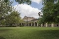
7,360 × 4,912 (206.9 MB) | Fæ | LOC 2014630475, Carol M. Highsmith collection. P149.10468 TIFF (206.9mb) |
File usage
The following page uses this file:
Global file usage
The following other wikis use this file:
- Usage on de.wikipedia.org
- Usage on en.wikipedia.org
Metadata
This file contains additional information, probably added from the digital camera or scanner used to create or digitize it.
If the file has been modified from its original state, some details may not fully reflect the modified file.
Image title | Some of the buildings at Fort Brown in Brownsville, Texas. The fort was a military post of the United States Army in Texas during the later half of 19th century and the early part of the 20th century. In 1846, under orders from Zachary Taylor, Captain Joseph K. Mansfield built a star-shaped earthwork for 800 men called "Fort Texas" on the northern side of the Rio Grande, "by the order from General Taylor to command the city of Matamoros". The next year, the fort played a role during the opening of the Mexican-American War. During the Siege of Fort Texas, two Americans were killed, including Major Jacob Brown. In honor of the fallen major, General Zachary Taylor renamed the post Fort Brown. In 1849, the city of Brownsville, Texas, was established not far from the fort's grounds. Almost a century later, on Feburary 1, 1946, Fort Brown was decommissioned and turned over to the Army Corps of Engineers. It was acquired by the City of Brownsville in 1948 and became part of what is now the Texas Southmost College campus. |
---|---|
Camera manufacturer | NIKON CORPORATION |
Camera model | NIKON D800 |
Author | Photographer: Carol M. Highsmith |
Exposure time | 1/125 sec (0.008) |
F Number | f/10 |
ISO speed rating | 100 |
Date and time of data generation | 15:34, 14 March 2014 |
Lens focal length | 24 mm |
Latitude | 25° 53′ 55.57″ N |
Longitude | 97° 29′ 33.51″ W |
Altitude | 6 meters above sea level |
Width | 7,360 px |
Height | 4,912 px |
Bits per component |
|
Compression scheme | Uncompressed |
Pixel composition | RGB |
Image data location | 32,000 |
Orientation | Normal |
Number of components | 3 |
Number of rows per strip | 4,912 |
Bytes per compressed strip | 216,913,920 |
Horizontal resolution | 300 dpi |
Vertical resolution | 300 dpi |
Data arrangement | chunky format |
Software used | Ver.1.02 |
File change date and time | 15:51, 16 March 2014 |
Exposure Program | Manual |
Exif version | 2.21 |
Date and time of digitizing | 15:34, 14 March 2014 |
APEX shutter speed | 6.965784 |
APEX aperture | 6.643856 |
APEX exposure bias | 0 |
Maximum land aperture | 3 APEX (f/2.83) |
Metering mode | Pattern |
Light source | Unknown |
Flash | Flash did not fire, compulsory flash suppression |
DateTimeOriginal subseconds | 2 |
Color space | Uncalibrated |
Focal plane X resolution | 2,048.4022216797 |
Focal plane Y resolution | 2,048.4022216797 |
Focal plane resolution unit | 3 |
Sensing method | One-chip color area sensor |
File source | Digital still camera |
Scene type | A directly photographed image |
Custom image processing | Normal process |
Exposure mode | Manual exposure |
White balance | Auto white balance |
Digital zoom ratio | 1 |
Focal length in 35 mm film | 24 mm |
Scene capture type | Standard |
Scene control | None |
Contrast | Normal |
Saturation | Normal |
Sharpness | Normal |
Subject distance range | Unknown |
GPS time (atomic clock) | 20:34 |
Satellites used for measurement | 07 |
Reference for direction of image | Magnetic direction |
Direction of image | 270.6 |
Geodetic survey data used | WGS 84 |
GPS date | 14 March 2014 |
GPS tag version | 2.3.0.0 |