
 Français
 Italiano
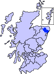
No higher resolution available.
ScotlandAberdeenshireFormartine.png (191 × 261 pixels, file size: 4 KB, MIME type: image/png)
This is a file from the Wikimedia Commons and may be used by other projects. Information from its description page there is shown below. Commons is a freely licensed media file repository. |
Summary
| Description | Aberdeenshire unitary council - Formartine Area |
| Source | Slightly edited version of a map drawn by Morwen and Voyager |
| Author |
Licensing
I, the copyright holder of this work, hereby publish it under the following licenses:
 | Permission is granted to copy, distribute and/or modify this document under the terms of the GNU Free Documentation License, Version 1.2 or any later version published by the Free Software Foundation; with no Invariant Sections, no Front-Cover Texts, and no Back-Cover Texts. A copy of the license is included in the section entitled GNU Free Documentation License. |
| This file is licensed under the Creative Commons Attribution-Share Alike 3.0 Unported license. | ||
| ||
| This licensing tag was added to this file as part of the GFDL licensing update. |
You may select the license of your choice.
File history
Click on a date/time to view the file as it appeared at that time.
| Date/Time | Thumbnail | Dimensions | User | Comment | |
|---|---|---|---|---|---|
| current | 01:07, 8 November 2007 | | 191 × 261 (4 KB) | Harami2000 | == Summary == == Summary == {{Information |Description= Aberdeenshire unitary council - Formartine Area |Source= Slightly edited version of a map drawn by Morwen and Voyager |Date= |Author= |Permission= |other_ve |
File usage
There are no pages that use this file.
Global file usage
The following other wikis use this file:
- Usage on en.wikipedia.org
- Aberdeenshire
- Fyvie Castle
- Delgatie Castle
- Ellon, Aberdeenshire
- Forvie National Nature Reserve
- Newburgh, Aberdeenshire
- Turriff
- Fyvie
- Oldmeldrum
- Collieston
- Ythan Estuary
- Auchterless
- Gight
- Balmedie
- Formartine
- Craigston Castle
- Methlick
- Formartine and Buchan Way
- Haddo House
- Pitmedden Garden
- Barthol Chapel
- Pitmedden
- Foveran
- Cuminestown
- Blackdog
- Belhelvie
- Tarves
- Inverkeithny
- Bogton
- Cairnorrie
- Rothienorman
- Tolquhon Castle
- Template:Formartine, Aberdeenshire places
- Knockhall Castle
- Ythanbank
- Potterton
- Woodhead, Aberdeenshire
- Whiterashes
- Udny Station
- Udny Green
- Garmond, Aberdeenshire
- Esslemont Castle
- Whitecairns
- Craigdam
- Gordonstown, Formartine
- Usage on ga.wikipedia.org
Explore the world

United states
New York

Japan
Tokyo

Singapore
Singapore
