
 Français
 Italiano
Size of this preview: 776 × 599 pixels. Other resolutions: 311 × 240 pixels | 622 × 480 pixels | 994 × 768 pixels | 1,280 × 989 pixels | 2,560 × 1,977 pixels | 4,069 × 3,143 pixels.
Original file (4,069 × 3,143 pixels, file size: 12.26 MB, MIME type: image/png)
This is a file from the Wikimedia Commons and may be used by other projects. Information from its description page there is shown below. Commons is a freely licensed media file repository. |
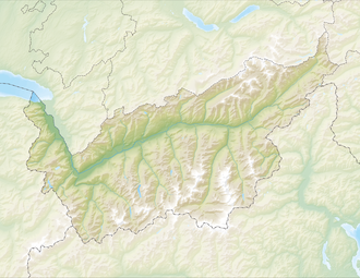
| Description | Deutsch: Reliefkarte des Kantons Wallis Topographischer Hintergrund: NASA Shuttle Radar Topography Mission (public domain). SRTM3 v.2. | ||||||||
| Date | |||||||||
| Source | Own work | ||||||||
| Author | Tschubby | ||||||||
| Permission (Reusing this file) | I, the copyright holder of this work, hereby publish it under the following licenses:
This file is licensed under the Creative Commons Attribution-Share Alike 2.5 Generic, 2.0 Generic and 1.0 Generic license.
You may select the license of your choice. | ||||||||
| Other versions | Derivative works of this file: Massa river Route.png |

File history
Click on a date/time to view the file as it appeared at that time.
| Date/Time | Thumbnail | Dimensions | User | Comment | |
|---|---|---|---|---|---|
| current | 12:18, 6 December 2013 | | 4,069 × 3,143 (12.26 MB) | Tschubby | {{Information |Description= {{de| Reliefkarte des Kantons Wallis}} Topographischer Hintergrund: [http://www2.jpl.nasa.gov/srtm NASA Shuttle Radar Topography Mission] (public domain). SRTM3 v.2. |Source={{own}} |Date= 2013-12-06 |Author= [[:de:User:Tsch... |
File usage
There are no pages that use this file.
Global file usage
The following other wikis use this file:
- Usage on als.wikipedia.org
- Usage on arz.wikipedia.org
- Usage on da.wikipedia.org
- Usage on de.wikipedia.org
- Dom (Berg)
- Bietschhorn
- Simplontunnel
- Pollux (Berg)
- Castor (Berg)
- Lötschbergtunnel
- Lac de Cleuson
- Lac des Dix
- Dent de Morcles
- Dents du Midi
- Zinalrothorn
- Grand Combin
- Alphubel
- Rhonegletscher
- Täschhorn
- Weisshorn (Wallis)
- Stausee Mattmark
- Dent Blanche
- Otemmagletscher
- Corbassièregletscher
- Giétrozgletscher
- Lac d’Emosson
- Gornergletscher
- Fieschergletscher
- Tsanfleurongletscher
- Findelgletscher
- Ferpècle-Gletscher
- Mont-Miné-Gletscher
- Feegletscher
- Allalingletscher
- Hohlaubgletscher
- Trientgletscher
- Moirygletscher
- Oberaletschgletscher
- Mittelaletschgletscher
- Saleinagletscher
- Brenaygletscher
- Tsijiore-Nouve-Gletscher
- Cheilongletscher
- Mont-Durand-Gletscher
View more global usage of this file.
Metadata
Explore the world

United states
New York

Japan
Tokyo

Singapore
Singapore
