
 Français
 Italiano
Size of this preview: 670 × 600 pixels. Other resolutions: 268 × 240 pixels | 536 × 480 pixels | 858 × 768 pixels | 1,144 × 1,024 pixels | 2,288 × 2,048 pixels | 4,822 × 4,317 pixels.
Original file (4,822 × 4,317 pixels, file size: 19.33 MB, MIME type: image/png)
This is a file from the Wikimedia Commons and may be used by other projects. Information from its description page there is shown below. Commons is a freely licensed media file repository. |
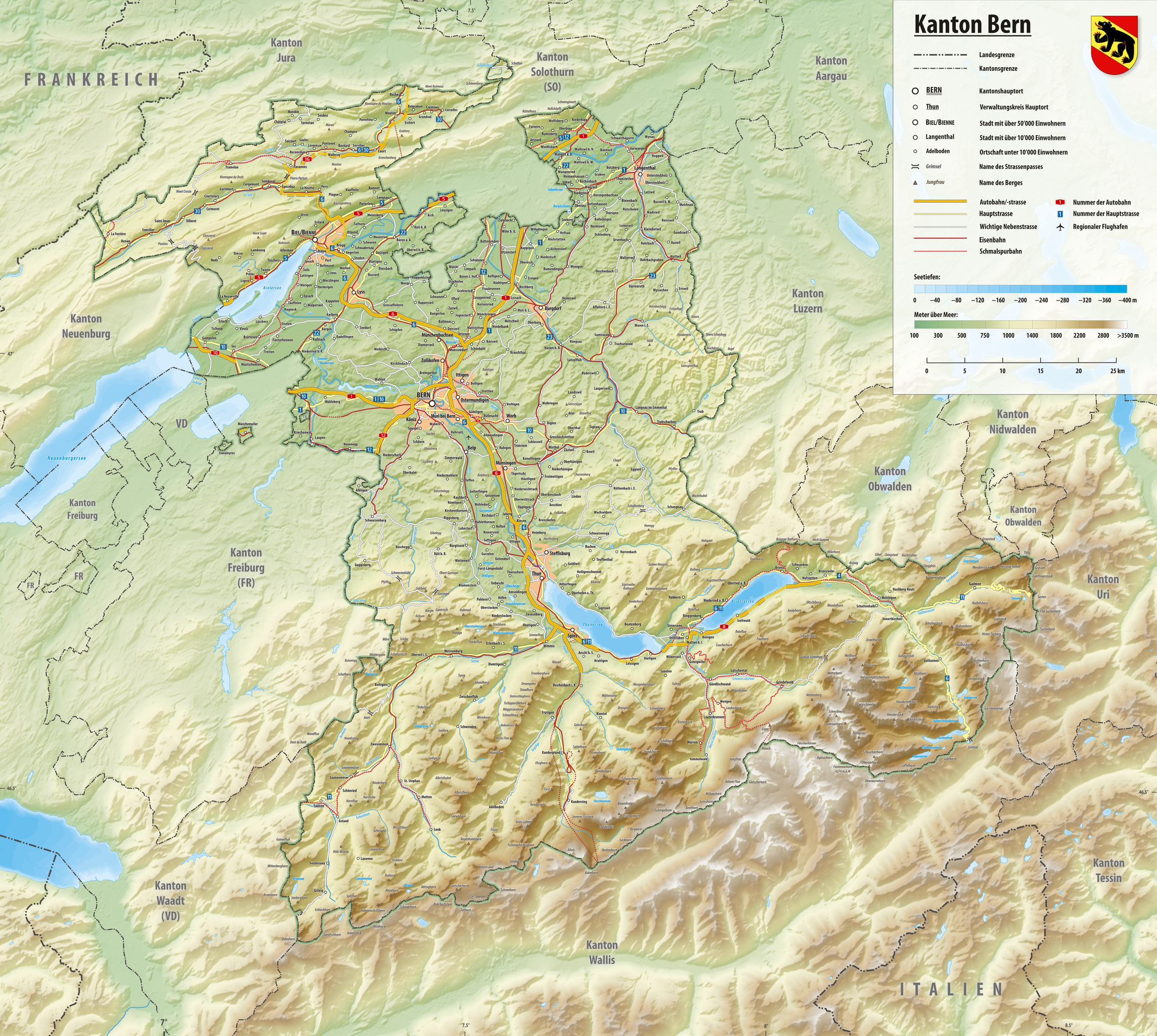
| Description | Deutsch: Reliefkarte des Kantons Bern Topographischer Hintergrund: NASA Shuttle Radar Topography Mission (public domain). SRTM3 v.2. | ||||||||
| Date | |||||||||
| Source | Own work | ||||||||
| Author | Tschubby | ||||||||
| Permission (Reusing this file) | I, the copyright holder of this work, hereby publish it under the following licenses:
This file is licensed under the Creative Commons Attribution-Share Alike 2.5 Generic, 2.0 Generic and 1.0 Generic license.
You may select the license of your choice. |

File history
Click on a date/time to view the file as it appeared at that time.
| Date/Time | Thumbnail | Dimensions | User | Comment | |
|---|---|---|---|---|---|
| current | 19:57, 18 July 2020 | | 4,822 × 4,317 (19.33 MB) | Tschubby | {{Information |description= |date= |source= |author= |permission= |other versions= }} |
| 09:28, 26 January 2019 |  | 4,822 × 4,317 (19.33 MB) | Tschubby | {{Information |description= |date= |source= |author= |permission= |other versions= }} | |
| 09:30, 3 May 2016 |  | 4,021 × 3,600 (10.79 MB) | Tschubby | {{Information |Description= |Source= |Date= |Author= |Permission= |other_versions= }} | |
| 17:19, 31 August 2013 |  | 4,022 × 3,601 (15.5 MB) | Tschubby | {{Information |Description= |Source= |Date= |Author= |Permission= |other_versions= }} | |
| 16:48, 10 August 2013 |  | 4,022 × 3,601 (15.5 MB) | Tschubby | {{Information |Description= |Source= |Date= |Author= |Permission= |other_versions= }} | |
| 21:57, 20 July 2013 |  | 4,022 × 3,602 (15.88 MB) | Tschubby | {{Information |Description= |Source= |Date= |Author= |Permission= |other_versions= }} | |
| 20:49, 20 July 2013 |  | 4,022 × 3,601 (15.89 MB) | Tschubby | {{Information |Description= |Source= |Date= |Author= |Permission= |other_versions= }} | |
| 19:23, 1 May 2011 |  | 3,540 × 3,169 (13.5 MB) | Tschubby | {{Information |Description= |Source= |Date= |Author= |Permission= |other_versions= }} | |
| 19:01, 1 May 2011 |  | 3,539 × 3,170 (13.5 MB) | Tschubby | {{Information |Description= {{de| Reliefkarte des Kantons Bern}} Topographischer Hintergrund: [http://www2.jpl.nasa.gov/srtm NASA Shuttle Radar Topography Mission] (public domain). SRTM3 v.2. |Source={{own}} |Date= 2011-05-01 |Author= [[:de:User:Tschubby| |
File usage
There are no pages that use this file.
Global file usage
The following other wikis use this file:
- Usage on als.wikipedia.org
- Usage on be.wikipedia.org
- Usage on ca.wikipedia.org
- Usage on de.wikipedia.org
- Usage on en.wikipedia.org
- Jungfrau
- Lake Neuchâtel
- Lake Thun
- Lake Brienz
- Lake Biel
- Lake Sarnen
- Lake Wohlen
- Lake Lungern
- Grimselsee
- Col du Mont Crosin
- Bachalpsee
- Blausee
- Burgäschisee
- Etang de la Gruère
- Amsoldingersee
- Uebeschisee
- Totesee
- Oeschinen Lake
- Lauenensee
- Oberaarsee
- Arnensee
- Gelmersee
- Räterichsbodensee
- St. Peter's Island
- Inkwilersee
- Melchsee
- Lac de Tseuzier
- Engstlensee
- Tannensee
- Dittligsee
- Hinterburgsee
- Sägistalsee
- Seebergsee
- Gerzensee (lake)
- Daubensee
- Moossee
- Niederriedsee
- Iffigsee
- Mattenalpsee
- Oberstockensee
- Wichelsee
- Lac de Sanetsch
- Egelsee (Bern)
- Geistsee
- Hagelseeli
- Old City (Bern)
View more global usage of this file.
Metadata
Explore the world

United states
New York

Japan
Tokyo

Singapore
Singapore
