
 Français
 Italiano
Size of this PNG preview of this SVG file: 800 × 537 pixels. Other resolutions: 320 × 215 pixels | 640 × 429 pixels | 1,024 × 687 pixels | 1,280 × 858 pixels | 2,560 × 1,717 pixels | 1,421 × 953 pixels.
Original file (SVG file, nominally 1,421 × 953 pixels, file size: 443 KB)
This is a file from the Wikimedia Commons and may be used by other projects. Information from its description page there is shown below. Commons is a freely licensed media file repository. |
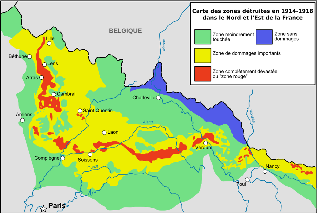
| Description | English: Zone rouge Map, describing in red zones completly destroyed by first world war / See also (french) [:http://fr.wikipedia.org/wiki/Zone_rouge_%28s%C3%A9quelles_de_guerre%29 French page of Wikipedia about red zone] La petite carte présente les bassins hydrographiques européens les plus concernés. Cette carte ne vaut que pour la France, mais la Belgique a également été très touchée (d'après Guicherd, J., & Matriot, C. (1921). La terre des régions dévastées'. Journal d'Agriculture Pratique, 34, 154-6.). Français : Cartographie des zones bleues, rouges et jaunes telles que décidées ou négociées après la fin de la Première Guerre mondiale (d'après Guicherd, J., & Matriot, C. (1921). La terre des régions dévastées'. Journal d'Agriculture Pratique, 34, 154-6.). |
| Date | (UTC) |
| Source | |
| Author |
|
| Other versions | Derivative works of this file: Red Zone Map-de.svg |
| This is a retouched picture, which means that it has been digitally altered from its original version. The original can be viewed here: Zone rougeRed Zone Map.jpg: File:Zone rougeRed Zone Map.jpg.
|
I, the copyright holder of this work, hereby publish it under the following license:
This file is licensed under the Creative Commons Attribution-Share Alike 2.5 Generic license.
- You are free:
- to share – to copy, distribute and transmit the work
- to remix – to adapt the work
- Under the following conditions:
- attribution – You must give appropriate credit, provide a link to the license, and indicate if changes were made. You may do so in any reasonable manner, but not in any way that suggests the licensor endorses you or your use.
- share alike – If you remix, transform, or build upon the material, you must distribute your contributions under the same or compatible license as the original.
Original upload log
This image is a derivative work of the following images:
- Image:Zone_rougeRed_Zone_Map.jpg licensed with Cc-by-sa-2.5
- 2008-03-13T16:44:02Z Zertrin 1894x1132 (538104 Bytes) {{Information |Description=Zone rouge Map, describing in red zones completly destroyed by first world war / See also (french) [:http://fr.wikipedia.org/wiki/Zone_rouge_%28s%C3%A9quelles_de_guerre%29 French page of Wikipedia
- 2006-12-10T22:49:03Z Lamiot 1894x1132 (511373 Bytes) {{Information |Description= Zone rouge Map, describing in red zones completly destroyed by first world war / See also (french) [:http://fr.wikipedia.org/wiki/Zone_rouge_%28s%C3%A9quelles_de_guerre%29 French page of Wikipedia
Uploaded with derivativeFX
File history
Click on a date/time to view the file as it appeared at that time.
| Date/Time | Thumbnail | Dimensions | User | Comment | |
|---|---|---|---|---|---|
| current | 15:37, 16 September 2008 | | 1,421 × 953 (443 KB) | Tinodela | {{Information |Description= |Source= |Date= |Author= |Permission= |other_versions= }} |
| 15:36, 16 September 2008 |  | 1,421 × 953 (391 KB) | Tinodela | {{Information |Description=Zone rouge Map, describing in red zones completly destroyed by first world war / See also (french) [:http://fr.wikipedia.org/wiki/Zone_rouge_%28s%C3%A9quelles_de_guerre%29 French page of Wikipedia about red zone] La petite cart |
File usage
The following page uses this file:
Global file usage
The following other wikis use this file:
- Usage on ar.wikipedia.org
- Usage on en.wikipedia.org
- Usage on fr.wikipedia.org
- Première Guerre mondiale
- Zone rouge (séquelles de guerre)
- Reconstruction en France et en Belgique après la Première Guerre mondiale
- Grande Dépression en France
- Discussion Wikipédia:Wikiconcours/septembre 2008/Équipes/Équipe 4
- Front de l'Ouest (Première Guerre mondiale)
- Wikipédia:Atelier graphique/Cartes/Archives/novembre 2011
- Occupation de la France par l'Allemagne pendant la Première Guerre mondiale
- Usage on he.wikipedia.org
- Usage on ig.wikipedia.org
- Usage on it.wikipedia.org
- Usage on ko.wikipedia.org
- Usage on ml.wikipedia.org
- Usage on pl.wikipedia.org
- Usage on pt.wikipedia.org
- Usage on ru.wikipedia.org
- Usage on sr.wikipedia.org
- Usage on sv.wikipedia.org
- Usage on tr.wikipedia.org
- Usage on uk.wikipedia.org
- Usage on www.wikidata.org
Metadata
Explore the world

United states
New York

Japan
Tokyo

Singapore
Singapore
