
 Français
 Italiano
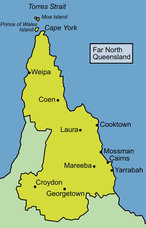
Size of this preview: 384 × 599 pixels. Other resolutions: 154 × 240 pixels | 510 × 795 pixels.
Original file (510 × 795 pixels, file size: 28 KB, MIME type: image/png)
This is a file from the Wikimedia Commons and may be used by other projects. Information from its description page there is shown below. Commons is a freely licensed media file repository. |
 | This locator map image could be re-created using vector graphics as an SVG file. This has several advantages; see Commons:Media for cleanup for more information. If an SVG form of this image is available, please upload it and afterwards replace this template with {{vector version available|new image name}}.It is recommended to name the SVG file “Queensland far north map.svg”—then the template Vector version available (or Vva) does not need the new image name parameter. |
Summary
Map of Far North Queensland, based on information from several maps including [1] archive copy at the Wayback Machine
Licensing
 | Permission is granted to copy, distribute and/or modify this document under the terms of the GNU Free Documentation License, Version 1.2 or any later version published by the Free Software Foundation; with no Invariant Sections, no Front-Cover Texts, and no Back-Cover Texts. A copy of the license is included in the section entitled GNU Free Documentation License. |
| This file is licensed under the Creative Commons Attribution-Share Alike 3.0 Unported license. | ||
| ||
| This licensing tag was added to this file as part of the GFDL licensing update. |
File history
Click on a date/time to view the file as it appeared at that time.
| Date/Time | Thumbnail | Dimensions | User | Comment | |
|---|---|---|---|---|---|
| current | 12:29, 6 January 2006 | | 510 × 795 (28 KB) | Roke~commonswiki | Map of Far North Queensland, I made the map, based on information from several maps including [http://publib.slq.qld.gov.au/directory/mfarnorth.htm] |
File usage
There are no pages that use this file.
Global file usage
The following other wikis use this file:
- Usage on de.wikipedia.org
- Usage on el.wikipedia.org
- Usage on en.wikipedia.org
- Bulleringa National Park
- Cape Melville National Park (Cape York Peninsula Aboriginal Land)
- Chillagoe-Mungana Caves National Park
- Flinders Group National Park (Cape York Peninsula Aboriginal Land)
- Forty Mile Scrub National Park
- Hann Tableland National Park
- Hull River National Park
- Errk Oykangand National Park
- Paluma Range National Park
- Rocky Islets National Park
- Russell River National Park
- Staaten River National Park
- Juunju Daarrba Nhirrpan National Park (Cape York Peninsula Aboriginal Land)
- Three Islands National Park
- Turtle Group National Park
- Two Islands National Park
- Curtain Fig National Park
- Mungana
- Bouncing Stones
- Walshs Pyramid
- Gillies Range
- Bathurst Bay
- Trinity Bay (Queensland)
- Crystal Cascades
- The Pinnacles (Atherton Tableland)
- Malanda Falls Conservation Park
- Mutee Head
- User:Roke/maps/Australia
- Bowden Island
- High Island (Queensland)
- Haycock Island
- Tinaroo Falls
- Josephine Falls
- Malanda Falls
- Millstream Falls
- Murray Falls
- Herbert River Falls
- Milmilgee Falls
- Wongalee Falls
- Kearneys Falls
- Clamshell Falls
- Whites Falls
- Davies Creek Falls
- Stoney Creek Falls
- Koombooloomba Hydro Power Station
- Windy Hill Wind Farm
- Template:FarNorthQueensland-geo-stub
View more global usage of this file.
Explore the world

United states
New York

Japan
Tokyo

Singapore
Singapore
