
 Français
 Italiano
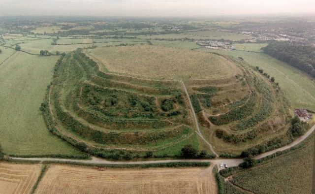
No higher resolution available.
Old_Oswestry_Hillfort_(aerial).jpg (640 × 394 pixels, file size: 138 KB, MIME type: image/jpeg)
This is a file from the Wikimedia Commons and may be used by other projects. Information from its description page there is shown below. Commons is a freely licensed media file repository. |
.jpg)
Summary
| Description | English: Old Oswestry Hillfort. Above and looking along the entrance to the Hillfort and across Shropshire. Intersecting with Wat's Dyke. |
| Date | |
| Source | https://www.geograph.org.uk/photo/3724089 |
| Author | Oswestry Borderland Tourism |
| Attribution (required by the license) | Credit Oswestry Borderland Tourism / Old Oswestry Hillfort / |
| Camera location | | View this and other nearby images on: OpenStreetMap |
|---|
.jpg¶ms=052.871285_N_-002.949838_E_globe:Earth_type:camera_heading:90.00&language=en)
Licensing
 | This image was taken from the Geograph project collection. See this photograph's page on the Geograph website for the photographer's contact details. The copyright on this image is owned by Credit Oswestry Borderland Tourism and is licensed for reuse under the Creative Commons Attribution-ShareAlike 2.0 license. |
This file is licensed under the Creative Commons Attribution-Share Alike 2.0 Generic license.
Attribution: Credit Oswestry Borderland Tourism
- You are free:
- to share – to copy, distribute and transmit the work
- to remix – to adapt the work
- Under the following conditions:
- attribution – You must give appropriate credit, provide a link to the license, and indicate if changes were made. You may do so in any reasonable manner, but not in any way that suggests the licensor endorses you or your use.
- share alike – If you remix, transform, or build upon the material, you must distribute your contributions under the same or compatible license as the original.
File history
Click on a date/time to view the file as it appeared at that time.
| Date/Time | Thumbnail | Dimensions | User | Comment | |
|---|---|---|---|---|---|
| current | 09:02, 7 April 2017 | | 640 × 394 (138 KB) | Emerald-wiki | User created page with UploadWizard |
File usage
The following page uses this file:
Global file usage
The following other wikis use this file:
- Usage on de.wikipedia.org
- Usage on en.wikipedia.org
- Usage on he.wikipedia.org
- Usage on www.wikidata.org
- Usage on zh.wikipedia.org
.jpg)
Explore the world

United states
New York

Japan
Tokyo

Singapore
Singapore
