
 Français
 Italiano
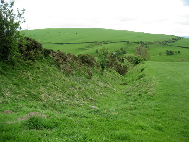
No higher resolution available.
Offa's_Dyke_near_Clun.jpg (640 × 480 pixels, file size: 86 KB, MIME type: image/jpeg)
This is a file from the Wikimedia Commons and may be used by other projects. Information from its description page there is shown below. Commons is a freely licensed media file repository. |
Summary
| Description | English: Offa's Dyke - the best bit. |
| Date | |
| Source | see below |
| Author | Chris Heaton |
| Camera location | | View this and other nearby images on: OpenStreetMap |
|---|
Licensing
 | This image was taken from the Geograph project collection. See this photograph's page on the Geograph website for the photographer's contact details. The copyright on this image is owned by Chris Heaton and is licensed for reuse under the Creative Commons Attribution-ShareAlike 2.0 license. |
This file is licensed under the Creative Commons Attribution-Share Alike 2.0 Generic license.
Attribution: Chris Heaton
- You are free:
- to share – to copy, distribute and transmit the work
- to remix – to adapt the work
- Under the following conditions:
- attribution – You must give appropriate credit, provide a link to the license, and indicate if changes were made. You may do so in any reasonable manner, but not in any way that suggests the licensor endorses you or your use.
- share alike – If you remix, transform, or build upon the material, you must distribute your contributions under the same or compatible license as the original.
File history
Click on a date/time to view the file as it appeared at that time.
| Date/Time | Thumbnail | Dimensions | User | Comment | |
|---|---|---|---|---|---|
| current | 09:53, 17 November 2008 | | 640 × 480 (86 KB) | Ghmyrtle | {{Information |Description={{en|1={{Information |Description=Offa's Dyke - The Best Bit |Source=From [http://www.geograph.org.uk/photo/819947 geograph.org.uk] |Date=2008-05-19 |Author=[http://www.geograph.org.uk/profile/3298 Chris Heaton] |Permission=Crea |
File usage
There are no pages that use this file.
Global file usage
The following other wikis use this file:
- Usage on br.wikipedia.org
- Usage on ca.wikipedia.org
- Usage on cs.wikipedia.org
- Usage on cy.wikipedia.org
- Usage on de.wikipedia.org
- Usage on en.wikipedia.org
- Usage on es.wikipedia.org
- Usage on et.wikipedia.org
- Usage on fi.wikipedia.org
- Usage on fr.wikipedia.org
- Discussion:Digue d'Offa
- Utilisateur:Malost/Bac à sable 5
- Portail:Anglo-Saxons/Image
- Marches galloises
- Wikipédia:Le saviez-vous ?/Anecdotes proposées/Archivage des discussions/Archives/2016-4
- Wikipédia:Statistiques des anecdotes de la page d'accueil/Visibilité des anecdotes (2017)
- Wikipédia:Statistiques des anecdotes de la page d'accueil/Visibilité des anecdotes (2017)/2017 02
- Wikipédia:Le saviez-vous ?/Archives/2017
- Usage on gl.wikipedia.org
- Usage on he.wikipedia.org
- Usage on it.wikipedia.org
- Usage on ko.wikipedia.org
- Usage on nl.wikipedia.org
- Usage on ru.wikipedia.org
- Usage on sh.wikipedia.org
- Usage on www.wikidata.org
Explore the world

United states
New York

Japan
Tokyo

Singapore
Singapore
