
 Français
 Italiano
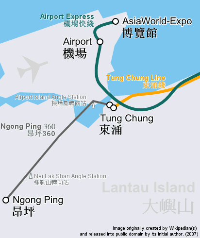
No higher resolution available.
Ngongping360_sameboat.png (412 × 490 pixels, file size: 28 KB, MIME type: image/png)
This is a file from the Wikimedia Commons and may be used by other projects. Information from its description page there is shown below. Commons is a freely licensed media file repository. |
| Description | Route map focusing on Hong Kong cable car Ngong Ping 360 and the nearby railway system, in geographically accurate scale. | ||
| Date | |||
| Source | Cropped and revised from image:Hong Kong Railway Route Map en.svg | ||
| Author | user:Sameboat | ||
| Permission (Reusing this file) |
| ||
| Other versions | Image:Ngongping360 map.png & Image:NgongPing360 map.jpg |
File history
Click on a date/time to view the file as it appeared at that time.
| Date/Time | Thumbnail | Dimensions | User | Comment | |
|---|---|---|---|---|---|
| current | 10:37, 26 December 2007 | | 412 × 490 (28 KB) | Sameboat | {{Information |Description= |Source= |Date= |Author= |Permission= |other_versions= }} |
| 11:30, 14 December 2007 |  | 412 × 490 (28 KB) | Sameboat | {{Information |Description=Route map focusing on Hong Kong cable car Ngong Ping 360 and the nearby railway system, in geographically accurate scale. |Source=Cropped and revised from image:Hong Kong Railway Route Map en.svg |Date=December, 2007 |Aut |
File usage
There are no pages that use this file.
Global file usage
The following other wikis use this file:
- Usage on bcl.wikipedia.org
- Usage on de.wikipedia.org
- Usage on en.wikipedia.org
- Usage on he.wikipedia.org
- Usage on sk.wikipedia.org
- Usage on zh-yue.wikipedia.org
- Usage on zh.wikipedia.org
Explore the world

United states
New York

Japan
Tokyo

Singapore
Singapore
