
 Français
 Italiano
Size of this PNG preview of this SVG file: 319 × 280 pixels. Other resolutions: 273 × 240 pixels | 547 × 480 pixels | 875 × 768 pixels | 1,167 × 1,024 pixels | 2,333 × 2,048 pixels.
Original file (SVG file, nominally 319 × 280 pixels, file size: 8 KB)
This is a file from the Wikimedia Commons and may be used by other projects. Information from its description page there is shown below. Commons is a freely licensed media file repository. |
Summary
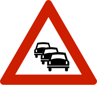
| Description | English: Norwegian road sign 149.0. Norsk bokmål: Norsk veiskilt 149.0. |
| Date | 10 July 2008 (upload date) |
| Source | EPS file downloaded from the Norwegian Public Roads Administration (Statens vegvesen) website: http://www.vegvesen.no/vegskilt/filnedlasting.stm |
| Author | Peter J. Acklam converted the original EPS file to PDF with Ghostscript and the PDF file to SVG with Inkscape. |
Licensing
| This image is in the public domain because it depicts a Norwegian road sign, produced by the The Norwegian Public Roads Administration (Statens vegvesen). The image may be used freely. |  |
File history
Click on a date/time to view the file as it appeared at that time.
| Date/Time | Thumbnail | Dimensions | User | Comment | |
|---|---|---|---|---|---|
| current | 23:48, 20 July 2013 | | 319 × 280 (8 KB) | Fry1989 | new |
| 13:54, 4 August 2008 |  | 744 × 652 (16 KB) | Pjacklam | Changed colours to the RGB values that Photoshop suggest for the original Pantone colours. | |
| 14:36, 10 July 2008 |  | 744 × 652 (16 KB) | Pjacklam | {{Information |Description={{en|1=Norwegian road sign 149.0.}} |Source=EPS file downloaded from the Norwegian Public Roads Administration (Statens vegvesen) website: http://www. |
File usage
There are no pages that use this file.
Global file usage
The following other wikis use this file:
- Usage on de.wikipedia.org
- Usage on en.wikipedia.org
- King William Street, London
- High Holborn
- Canada Square
- Saffron Hill
- Strand underpass
- A210 road
- Malet Street
- Deptford Market
- Gillespie Road
- London Dial-a-Ride
- Horse Guards Road
- Crouch Hill
- Electric Avenue
- A219 road
- Chalk Farm Road
- Lambeth Road
- York Road, Lambeth
- The Cut, London
- Blackfriars Road
- Southwark Bridge Road
- St George's Road
- Drummond Street, London
- Newington Causeway
- Great Dover Street
- A105 road
- Wapping Wall
- Tottenham High Road
- Wigmore Street
- Hercules Road
- Great Russell Street
- Cromwell Gardens
- Broadway, London
- Stepney Causeway
- A118 road
- Chelsea Bridge Road
- Kennington Park Road
- Olympic Way
- Dulwich Village
- Bevis Marks
- Buckingham Gate
- A212 road
- A214 road
- A206 road
- A203 road
- A107 road
- Road signs in Norway
- Giltspur Street
- Knight's Hill, West Norwood
View more global usage of this file.
Metadata
Explore the world

United states
New York

Japan
Tokyo

Singapore
Singapore
