
 Français
 Italiano
Size of this preview: 800 × 525 pixels. Other resolutions: 320 × 210 pixels | 640 × 420 pixels | 1,024 × 672 pixels | 1,280 × 840 pixels | 2,000 × 1,312 pixels.
Original file (2,000 × 1,312 pixels, file size: 1.32 MB, MIME type: image/jpeg)
This is a file from the Wikimedia Commons and may be used by other projects. Information from its description page there is shown below. Commons is a freely licensed media file repository. |
.jpg)
Summary
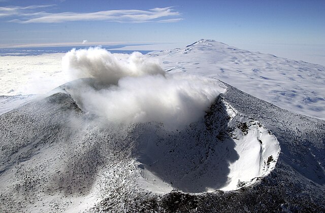
| Description | English: Aerial view of Mount Erebus craters in the foreground with Mount Terror in the background, Ross Island, Antarctica Français : Vue aérienne des cratères du mont Erebus au premier plan et du mont Terror au dernier plan, île de Ross, Antarctique |
| Date | |
| Source | United States Antarctic Program - Antarctic Photo Library |
| Author | NSF/Josh Landis, employee 1999-2001 |
Licensing
| This image is a work of a National Science Foundation employee, taken or made as part of that person's official duties. As a work of the U.S. federal government, the image is in the public domain. |  |
File history
Click on a date/time to view the file as it appeared at that time.
| Date/Time | Thumbnail | Dimensions | User | Comment | |
|---|---|---|---|---|---|
| current | 19:09, 8 March 2008 | | 2,000 × 1,312 (1.32 MB) | Rémih | == Summary == {{Information | Description={{en|Aerial view of Mount Erebus craters in the foreground with Mont Terror in the background, Ross Island, Antarctica}}{{fr|Vue aérienne des cratères du mont Erebus au premier plan et du mont Terror au dernier |
File usage
The following page uses this file:
Global file usage
The following other wikis use this file:
- Usage on ar.wikipedia.org
- Usage on de.wikipedia.org
- Usage on en.wikipedia.org
- Usage on fr.wikipedia.org
- Usage on id.wikipedia.org
- Usage on ja.wikipedia.org
- Usage on kw.wikipedia.org
- Usage on nl.wikipedia.org
- Usage on oc.wikipedia.org
- Usage on sk.wikipedia.org
- Usage on sv.wikipedia.org
Metadata
.jpg)
Explore the world

United states
New York

Japan
Tokyo

Singapore
Singapore
