
 Français
 Italiano
Size of this preview: 597 × 600 pixels. Other resolutions: 239 × 240 pixels | 478 × 480 pixels.
Original file (800 × 804 pixels, file size: 100 KB, MIME type: image/png)
This is a file from the Wikimedia Commons and may be used by other projects. Information from its description page there is shown below. Commons is a freely licensed media file repository. |
Summary
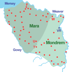
| Description | English: Sketch map of the forests of Mara and Mondrem (at a date between 1277 & 1536). Red dot: township within the forest; F: Frodsham; T: Tarporley; U: Utkinton; VR: Vale Royal Abbey; W: Weaverham. |
| Date | |
| Source | Own work |
| Author | Espresso Addict |
Licensing
I, the copyright holder of this work, hereby publish it under the following licenses:
This file is licensed under the Creative Commons Attribution-Share Alike 3.0 Unported license.
- You are free:
- to share – to copy, distribute and transmit the work
- to remix – to adapt the work
- Under the following conditions:
- attribution – You must give appropriate credit, provide a link to the license, and indicate if changes were made. You may do so in any reasonable manner, but not in any way that suggests the licensor endorses you or your use.
- share alike – If you remix, transform, or build upon the material, you must distribute your contributions under the same or compatible license as the original.
 | Permission is granted to copy, distribute and/or modify this document under the terms of the GNU Free Documentation License, Version 1.2 or any later version published by the Free Software Foundation; with no Invariant Sections, no Front-Cover Texts, and no Back-Cover Texts. A copy of the license is included in the section entitled GNU Free Documentation License. |
You may select the license of your choice.
File history
Click on a date/time to view the file as it appeared at that time.
| Date/Time | Thumbnail | Dimensions | User | Comment | |
|---|---|---|---|---|---|
| current | 08:50, 9 May 2010 | | 800 × 804 (100 KB) | Espresso Addict | Minor change to shading |
| 08:20, 9 May 2010 |  | 800 × 804 (100 KB) | Espresso Addict | {{Information |Description={{en|1=Sketch map of the forests of Mara and Mondrem (at a date between 1277 & 1536). Red dot: township within the forest; F: Frodsham; T: Tarporley; U: Utkinton; VR: Vale Royal Abbey; W: Weaverham. }} |Source={{own}} |Author=[[ |
File usage
There are no pages that use this file.
Global file usage
The following other wikis use this file:
- Usage on en.wikipedia.org
Explore the world

United states
New York

Japan
Tokyo

Singapore
Singapore
