
 Français
 Italiano
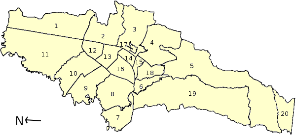
No higher resolution available.
Mapa_administrativa_Bogota.png (600 × 279 pixels, file size: 48 KB, MIME type: image/png)
This is a file from the Wikimedia Commons and may be used by other projects. Information from its description page there is shown below. Commons is a freely licensed media file repository. |
 | File:Administrative map of Bogotá.svg is a vector version of this file. It should be used in place of this PNG file when not inferior. File:Mapa administrativa Bogota.png → File:Administrative map of Bogotá.svg For more information, see Help:SVG. | .svg) |
Summary
| Description | Administrative Gliederung von Bogotá, Kolumbien / Municipalities of Bogotá, Colombia / Localidades de Bogotá, Colombia. 1 - Usaquén, 2 - Chapinero, 3 - Santafé, 4- San Cristóbal, 5 - Usme, 6 - Tunjuelito, 7 - Bosa, 8 - Kennedy, 9 - Fontibón, 10 - Engativá, 11 - Suba, 12 - Barrios Unidos, 13 - Teusaquillo, 14 - Los Mártires, 15 - Antonio Nariño, 16 - Puente Aranda, 17 - La Candelaria, 18 - Rafael Uribe, 19 - Ciudad Bolívar, 20 - Sumapaz |
| Date | |
| Source | Own work |
| Author | Louise Wolff (darina) |
Licensing
| I, the copyright holder of this work, release this work into the public domain. This applies worldwide. In some countries this may not be legally possible; if so: I grant anyone the right to use this work for any purpose, without any conditions, unless such conditions are required by law. |
File history
Click on a date/time to view the file as it appeared at that time.
| Date/Time | Thumbnail | Dimensions | User | Comment | |
|---|---|---|---|---|---|
| current | 18:50, 24 May 2006 | | 600 × 279 (48 KB) | Darina | == Beschreibung == {{Information| |Description=Administrative Gliederung von Bogotá, Kolumbien / Municipalities of Bogotá, Colombia / Localidades de Bogotá, Colombia. 1 - Usaquén, 2 - Chapinero, 3 - Santafé, 4- San Cristóbal, 5 - Usme, 6 - Tunjuel |
| 18:37, 24 May 2006 |  | 600 × 279 (47 KB) | Darina | == Beschreibung == {{Information| |Description=Administrative Gliederung von Bogotá, Kolumbien / Municipalities of Bogotá, Colombia / Localidades de Bogotá, Colombia. 1 - Usaquén, 2 - Chapinero, 3 - Santafé, 4- San Cristóbal, 5 - Usme, 6 - Tunjuel | |
| 18:24, 24 May 2006 |  | 600 × 279 (46 KB) | Darina | {{Information| |Description=Administrative Gliederung von Bogotá, Kolumbien / Municipalities of Bogotá, Colombia / Localidades de Bogotá, Colombia. 1 - Usaquén, 2 - Chapinero, 3 - Santafé, 4- San Cristóbal, 5 - Usme, 6 - Tunjuelito, 7 - Bosa, 8 - |
File usage
There are no pages that use this file.
Global file usage
The following other wikis use this file:
- Usage on hr.wikipedia.org
- Usage on hu.wikipedia.org
- Usage on ms.wikipedia.org
- Bogotá
- Templat:Bogota DC
- Usaquén
- Chapinero
- Santa Fe (Bogotá)
- San Cristóbal (Bogotá)
- Usme
- Tunjuelito
- Bosa (Bogotá)
- Kennedy (Bogotá)
- Fontibon
- Engativá
- Suba (Bogotá)
- Barrios Unidos
- Teusaquillo
- Los Mártires
- Antonio Nariño (Bogotá)
- Puente Aranda
- La Candelaria
- Rafael Uribe Uribe (Bogotá)
- Ciudad Bolívar (Bogotá)
- Sumapaz (Bogotá)
Explore the world

United states
New York

Japan
Tokyo

Singapore
Singapore
