
 Français
 Italiano
Size of this preview: 800 × 514 pixels. Other resolutions: 320 × 206 pixels | 640 × 411 pixels | 1,024 × 658 pixels | 1,280 × 823 pixels | 3,008 × 1,933 pixels.
Original file (3,008 × 1,933 pixels, file size: 1.2 MB, MIME type: image/png)
This is a file from the Wikimedia Commons and may be used by other projects. Information from its description page there is shown below. Commons is a freely licensed media file repository. |
Summary
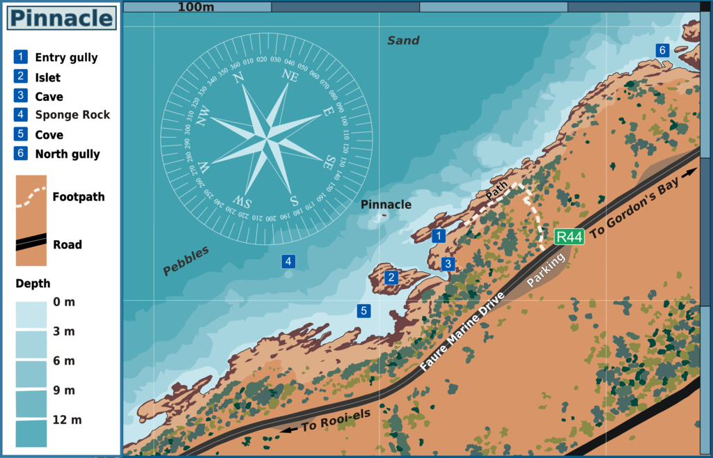
| Description | English: Map of the dive site Pinnacle near Gordon's Bay, on the east side of False Bay, Cape Peninsula. |
| Date | |
| Source | Peter Southwood |
| Author | Peter Southwood |
| Other versions | SVG source |
Licensing
User: (WT-shared) Pbsouthwood at wts wikivoyage, the copyright holder of this work, hereby publishes it under the following license:
This file is licensed under the Creative Commons Attribution-Share Alike 3.0 Unported license.
Attribution: User: (WT-shared) Pbsouthwood at wts wikivoyage
- You are free:
- to share – to copy, distribute and transmit the work
- to remix – to adapt the work
- Under the following conditions:
- attribution – You must give appropriate credit, provide a link to the license, and indicate if changes were made. You may do so in any reasonable manner, but not in any way that suggests the licensor endorses you or your use.
- share alike – If you remix, transform, or build upon the material, you must distribute your contributions under the same or compatible license as the original.
Original upload log
| This file was imported from Wikivoyage WTS. |
The original description page was here. All following user names refer to wts.wikivoyage-old.
org:
- 2009-08-13 07:46 (WT-shared) Pbsouthwood[dead link] 2400×1921 (235367 bytes) {{Imagecredit|credit=Peter Southwood|captureDate=2006|location=Gordon's Bay|source=P.B. Southwood|caption=|description=Map of the Cape Town (Import from wikitravel.org/shared)
- 2009-08-13 09:22 (WT-shared) Pbsouthwood[dead link] 1289×1097 (123475 bytes) {{Imagecredit|credit=Peter Southwood|captureDate=2005|location=Gordon's bay|source=P.B. Southwood|caption=|description=Map of the Cape Town (Import from wikitravel.org/shared)
- 2009-10-14 18:37 (WT-shared) Pbsouthwood[dead link] 2658×2058 (314672 bytes) {{Imagecredit|credit=Peter Southwood|captureDate=2009|location=Gordon's Bay|source=Pbsouthwood|caption=|description=}} (Import from wikitravel.org/shared)
- 2009-11-14 06:50 (WT-shared) Pbsouthwood[dead link] 2502×1609 (998035 bytes) {{Imagecredit|credit=Peter Southwood|captureDate=2009|location=Gordon's Bay, Western Cape|source=Original map on CorelDraw by [[User:Pbsouth (Import from wikitravel.org/shared)
- 2009-11-14 10:52 (WT-shared) Pbsouthwood[dead link] 3008×1933 (1258685 bytes) (Import from wikitravel.org/shared)
File history
Click on a date/time to view the file as it appeared at that time.
| Date/Time | Thumbnail | Dimensions | User | Comment | |
|---|---|---|---|---|---|
| current | 18:12, 15 December 2012 | | 3,008 × 1,933 (1.2 MB) | OgreBot | (BOT): Reverting to most recent version before archival |
| 18:12, 15 December 2012 |  | 2,502 × 1,609 (975 KB) | OgreBot | (BOT): Uploading old version of file from wts.wikivoyage; originally uploaded on 2009-11-14 06:50:11 by (WT-shared) Pbsouthwood | |
| 18:12, 15 December 2012 |  | 2,658 × 2,058 (307 KB) | OgreBot | (BOT): Uploading old version of file from wts.wikivoyage; originally uploaded on 2009-10-14 18:37:38 by (WT-shared) Pbsouthwood | |
| 18:12, 15 December 2012 |  | 1,289 × 1,097 (121 KB) | OgreBot | (BOT): Uploading old version of file from wts.wikivoyage; originally uploaded on 2009-08-13 09:22:58 by (WT-shared) Pbsouthwood | |
| 18:12, 15 December 2012 |  | 2,400 × 1,921 (230 KB) | OgreBot | (BOT): Uploading old version of file from wts.wikivoyage; originally uploaded on 2009-08-13 07:46:42 by (WT-shared) Pbsouthwood | |
| 19:21, 15 November 2012 |  | 3,008 × 1,933 (1.2 MB) | MGA73bot2 | {{BotMoveToCommons|wts.oldwikivoyage|year={{subst:CURRENTYEAR}}|month={{subst:CURRENTMONTHNAME}}|day={{subst:CURRENTDAY}}}} == {{int:filedesc}} == {{Information |description=Map of the Cape Peninsula and False Bay region dive site Pinnacle. Map of the ... |
File usage
The following 4 pages use this file:
Global file usage
The following other wikis use this file:
- Usage on www.wikidata.org
Explore the world

United states
New York

Japan
Tokyo

Singapore
Singapore
