
 Français
 Italiano
Size of this PNG preview of this SVG file: 654 × 600 pixels. Other resolutions: 262 × 240 pixels | 524 × 480 pixels | 838 × 768 pixels | 1,117 × 1,024 pixels | 2,234 × 2,048 pixels | 3,721 × 3,411 pixels.
Original file (SVG file, nominally 3,721 × 3,411 pixels, file size: 62 KB)
This is a file from the Wikimedia Commons and may be used by other projects. Information from its description page there is shown below. Commons is a freely licensed media file repository. |
Summary
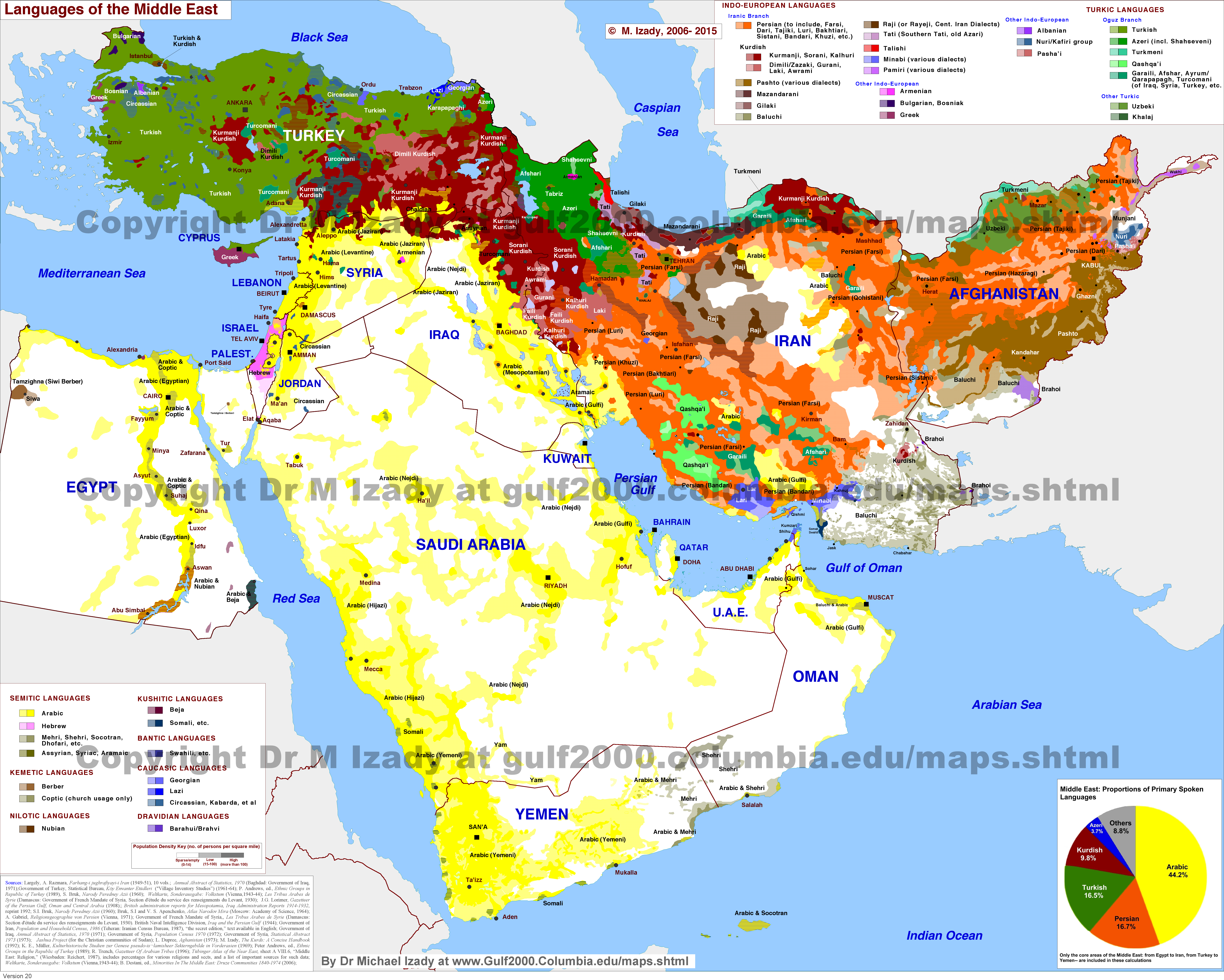
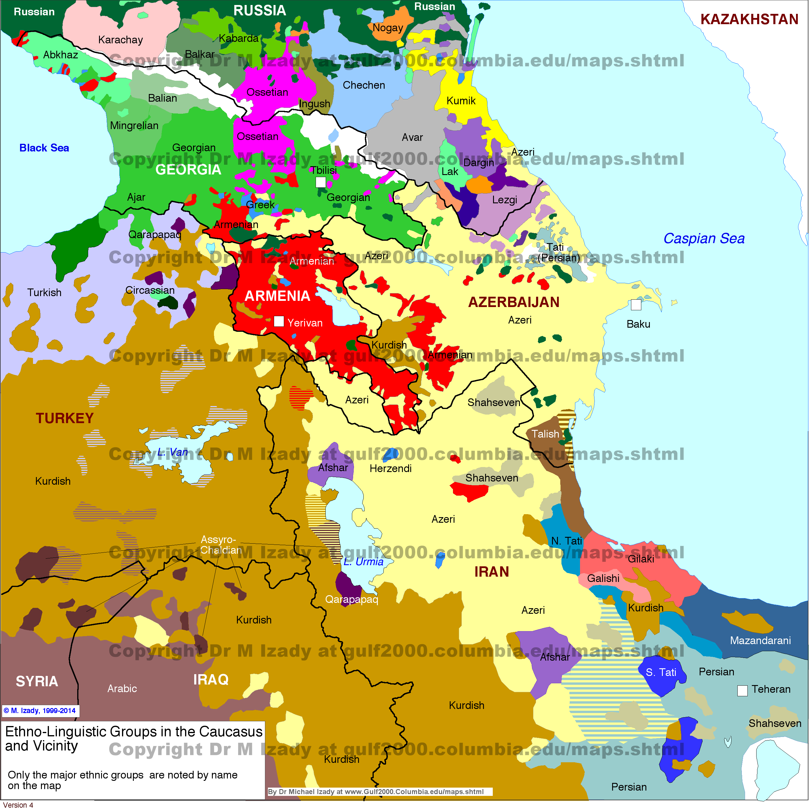
| Description | English: Distribution of the Azerbaijani language in the Caucasus and vicinity. Azərbaycanca: Azərbaycan dilinin Qafqazda və ətraf ərazilərdə yayılması. |
| Date | |
| Source | Own work.
|
| Author | Golden, based on File:Idioma azerí.png by User:Fobos92 |
| SVG development | This W3C-invalid map was created with Adobe Illustrator. |
Licensing
I, the copyright holder of this work, hereby publish it under the following license:
This file is licensed under the Creative Commons Attribution-Share Alike 4.0 International license.
- You are free:
- to share – to copy, distribute and transmit the work
- to remix – to adapt the work
- Under the following conditions:
- attribution – You must give appropriate credit, provide a link to the license, and indicate if changes were made. You may do so in any reasonable manner, but not in any way that suggests the licensor endorses you or your use.
- share alike – If you remix, transform, or build upon the material, you must distribute your contributions under the same or compatible license as the original.
File history
Click on a date/time to view the file as it appeared at that time.
| Date/Time | Thumbnail | Dimensions | User | Comment | |
|---|---|---|---|---|---|
| current | 13:44, 19 November 2023 | | 3,721 × 3,411 (62 KB) | Golden | correct Astara area per http://iranatlas.net/index.html?module=module.language-distribution.gilan_heritage |
| 12:55, 1 October 2023 |  | 4,651 × 4,264 (62 KB) | Golden | update Karabakh. Marking Lezgin, Avar, Talysh areas as light blue since they're all bilingual in Azeri too | |
| 18:27, 17 June 2023 |  | 4,651 × 4,264 (63 KB) | Golden | Reverted to version as of 15:00, 30 April 2023 (UTC) - Got a source for that? Astara in Iran is Azeri-speaking. Areas you added in Azerbaijan (Yardimli and parts of Lankaran) are again Azeri-speaking. Need I remind you that all Talysh in Azerbaijan are bilingual in Azeri too? | |
| 11:58, 17 June 2023 |  | 512 × 469 (158 KB) | AryanTuranica | Removed Talysh areas of Namin and Gilan. | |
| 15:00, 30 April 2023 |  | 4,651 × 4,264 (63 KB) | Golden | update lachin corridor | |
| 15:48, 2 January 2022 |  | 512 × 469 (64 KB) | Golden | Reverted to version as of 15:36, 2 January 2022 (UTC); rv not sure what went wrong | |
| 15:43, 2 January 2022 |  | 512 × 475 (523 KB) | Golden | various fixes (updated control in Nagorno-Karabakh; smoothed Derbent, Lezgis; fixes to Avars; style fix to Kalbajar panhandle) | |
| 15:36, 2 January 2022 |  | 512 × 469 (64 KB) | Golden | Reverted to version as of 10:18, 21 November 2021 (UTC); reverting to original because inkscape didn't fix the svg errors | |
| 10:42, 21 November 2021 |  | 512 × 469 (66 KB) | Golden | trying to fix svg errors again | |
| 10:33, 21 November 2021 |  | 512 × 469 (66 KB) | Golden | fixed svg errors with inkscape |
File usage
The following page uses this file:
Global file usage
The following other wikis use this file:
- Usage on ab.wikipedia.org
- Usage on ace.wikipedia.org
- Usage on af.wikipedia.org
- Usage on am.wikipedia.org
- Usage on ang.wikipedia.org
- Usage on an.wikipedia.org
- Usage on ar.wikipedia.org
- Usage on ary.wikipedia.org
- Usage on arz.wikipedia.org
- Usage on ast.wikipedia.org
- Usage on avk.wikipedia.org
- Usage on av.wikipedia.org
- Usage on azb.wikipedia.org
- Usage on az.wikipedia.org
- Usage on ban.wikipedia.org
- Usage on bat-smg.wikipedia.org
- Usage on ba.wikipedia.org
- Usage on bcl.wikipedia.org
- Usage on be-tarask.wikipedia.org
- Usage on be.wikipedia.org
- Usage on bg.wikipedia.org
- Usage on bn.wikipedia.org
- Usage on br.wikipedia.org
- Usage on bs.wikipedia.org
- Usage on ca.wikipedia.org
- Usage on ca.wiktionary.org
- Usage on cdo.wikipedia.org
- Usage on ceb.wikipedia.org
- Usage on ce.wikipedia.org
- Usage on ckb.wikipedia.org
- Usage on crh.wikipedia.org
- Usage on cs.wikipedia.org
- Usage on cv.wikipedia.org
- Usage on cy.wikipedia.org
- Usage on da.wikipedia.org
- Usage on de.wikipedia.org
- Usage on diq.wikipedia.org
- Usage on dsb.wikipedia.org
- Usage on el.wikipedia.org
View more global usage of this file.
Metadata
Explore the world

United states
New York

Japan
Tokyo

Singapore
Singapore
