
 Français
 Italiano
Size of this PNG preview of this SVG file: 286 × 186 pixels. Other resolutions: 320 × 208 pixels | 640 × 416 pixels | 1,024 × 666 pixels | 1,280 × 832 pixels | 2,560 × 1,665 pixels.
Original file (SVG file, nominally 286 × 186 pixels, file size: 167 KB)
This is a file from the Wikimedia Commons and may be used by other projects. Information from its description page there is shown below. Commons is a freely licensed media file repository. |
Clickable version
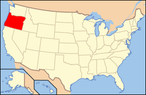
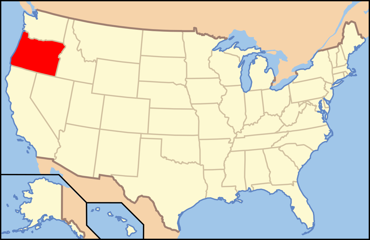
| Description | English: Map of United States with Oregon highlighted. |
| Source | Modified version of United States (Outline Map) 1998 from Perry-Castañeda Library Map Collection: United States Maps |
| Author | Huebi |
| Other versions | image:Map of USA with state names.svg |
| This file is licensed under the Creative Commons Attribution-Share Alike 3.0 Unported license. Subject to disclaimers. | ||
| ||
| This licensing tag was added to this file as part of the GFDL licensing update. |
 | Permission is granted to copy, distribute and/or modify this document under the terms of the GNU Free Documentation License, Version 1.2 or any later version published by the Free Software Foundation; with no Invariant Sections, no Front-Cover Texts, and no Back-Cover Texts. A copy of the license is included in the section entitled GNU Free Documentation License. Subject to disclaimers. |
This file is licensed under the Creative Commons Attribution 2.0 Generic license.
- You are free:
- to share – to copy, distribute and transmit the work
- to remix – to adapt the work
- Under the following conditions:
- attribution – You must give appropriate credit, provide a link to the license, and indicate if changes were made. You may do so in any reasonable manner, but not in any way that suggests the licensor endorses you or your use.
This file is licensed under the Creative Commons Attribution-Share Alike 1.0 Generic license.
- You are free:
- to share – to copy, distribute and transmit the work
- to remix – to adapt the work
- Under the following conditions:
- attribution – You must give appropriate credit, provide a link to the license, and indicate if changes were made. You may do so in any reasonable manner, but not in any way that suggests the licensor endorses you or your use.
- share alike – If you alter, transform, or build upon this work, you must distribute the resulting work under the same license as the original.
This file is licensed under the Creative Commons Attribution-Share Alike 2.0 Generic license.
- You are free:
- to share – to copy, distribute and transmit the work
- to remix – to adapt the work
- Under the following conditions:
- attribution – You must give appropriate credit, provide a link to the license, and indicate if changes were made. You may do so in any reasonable manner, but not in any way that suggests the licensor endorses you or your use.
- share alike – If you remix, transform, or build upon the material, you must distribute your contributions under the same or compatible license as the original.
File history
Click on a date/time to view the file as it appeared at that time.
| Date/Time | Thumbnail | Dimensions | User | Comment | |
|---|---|---|---|---|---|
| current | 09:47, 9 June 2006 | | 286 × 186 (167 KB) | Huebi~commonswiki | {{Information| |Description=Map of USA with Oregon highlighted |other_versions=image:Map of USA with state names.svg }} Category:Maps of the United States Category:Maps of Oregon Category:SVG maps {{GFDL-en}}{{cc-by-2.0}}{{cc-by-sa-1.0} |
File usage
There are no pages that use this file.
Global file usage
The following other wikis use this file:
- Usage on af.wikipedia.org
- Oregon
- Medford, Oregon
- Eugene, Oregon
- Coos Bay
- Astoria, Oregon
- Forest Grove
- La Grande
- Beaverton
- Pendleton, Oregon
- Corvallis
- Roseburg, Oregon
- Gaston, Oregon
- Aumsville, Oregon
- Ashland, Oregon
- Arlington, Oregon
- Bandon, Oregon
- Barlow, Oregon
- Athena, Oregon
- Amity, Oregon
- Aurora, Oregon
- Cove, Oregon
- Elgin, Oregon
- Echo, Oregon
- Fairview, Oregon
- Monmouth, Oregon
- Ione, Oregon
- Dufur, Oregon
- Moro, Oregon
- Tigard, Oregon
- Siletz, Oregon
- Veneta, Oregon
- Lonerock, Oregon
- Reedsport, Oregon
- Deelstate van die Verenigde State van Amerika
- Usage on ang.wikipedia.org
- Usage on an.wikipedia.org
- Usage on arc.wikipedia.org
- Usage on ay.wikipedia.org
- Usage on az.wikipedia.org
- Usage on az.wiktionary.org
- Usage on bat-smg.wikipedia.org
- Usage on be-tarask.wikipedia.org
- Usage on bi.wikipedia.org
- Usage on bn.wikipedia.org
- Usage on bpy.wikipedia.org
- Usage on bxr.wikipedia.org
View more global usage of this file.
Metadata
Explore the world

United states
New York

Japan
Tokyo

Singapore
Singapore
