
 Français
 Italiano
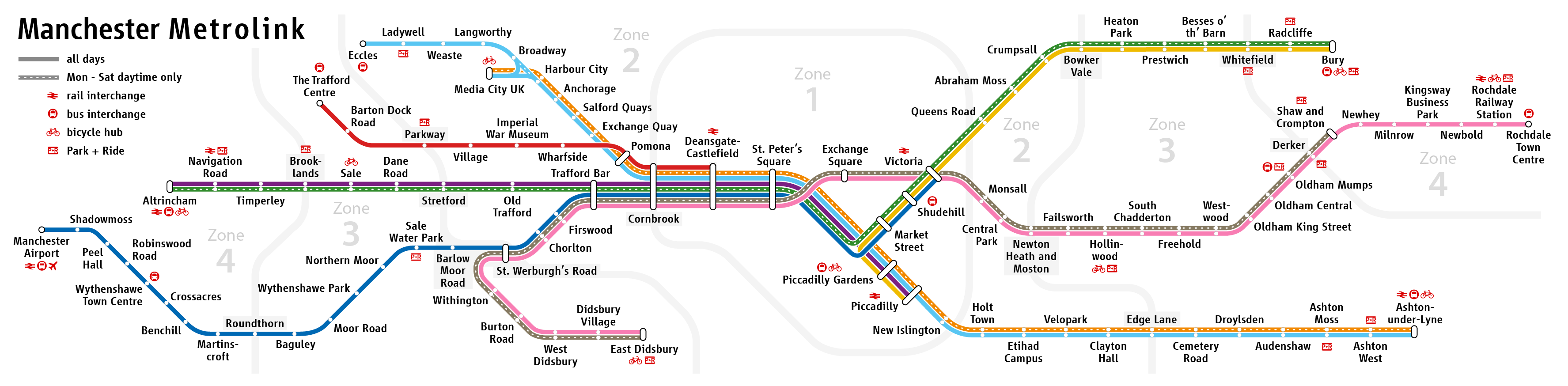
Size of this preview: 800 × 197 pixels. Other resolutions: 320 × 79 pixels | 640 × 158 pixels | 1,024 × 252 pixels | 3,550 × 874 pixels.
Original file (3,550 × 874 pixels, file size: 323 KB, MIME type: image/png)
This is a file from the Wikimedia Commons and may be used by other projects. Information from its description page there is shown below. Commons is a freely licensed media file repository. |
| Description |
|
| Date | see file history |
| Source | Own work |
| Author | Maximilian Dörrbecker (Chumwa) |
| Permission (Reusing this file) | This file is licensed under the Creative Commons Attribution-Share Alike 2.0 Generic license.
|
| Other versions |
|


 | This transport map image could be re-created using vector graphics as an SVG file. This has several advantages; see Commons:Media for cleanup for more information. If an SVG form of this image is available, please upload it and afterwards replace this template with {{vector version available|new image name}}.It is recommended to name the SVG file “Manchester Metrolink - Schemaplan.svg”—then the template Vector version available (or Vva) does not need the new image name parameter. |
File history
Click on a date/time to view the file as it appeared at that time.
| Date/Time | Thumbnail | Dimensions | User | Comment | |
|---|---|---|---|---|---|
| current | 19:28, 22 May 2024 | 3,550 × 874 (323 KB) | Delusion23 | Update: Trafford Centre line now runs to Deansgate | |
| 20:08, 4 February 2021 | 3,550 × 874 (322 KB) | Delusion23 | "intu Trafford Centre" has been renamed "The Trafford Centre" | ||
| 08:56, 13 June 2020 | 3,550 × 874 (298 KB) | Chumwa | updated Etihad Campus too | ||
| 08:53, 13 June 2020 | 3,550 × 874 (298 KB) | Chumwa | update on base of original map version | ||
| 19:15, 1 April 2020 | 3,550 × 874 (322 KB) | Delusion23 | Zone boundary stations like Parkway and Stretford have grey background behind text | ||
| 13:23, 31 March 2020 | 3,550 × 874 (346 KB) | G-13114 | Further small improvements | ||
| 11:54, 31 March 2020 | 3,550 × 874 (346 KB) | G-13114 | Further minor tweaks | ||
| 11:33, 31 March 2020 | 3,550 × 874 (346 KB) | G-13114 | Some small tweaks and tidying | ||
| 11:24, 31 March 2020 | 3,550 × 874 (346 KB) | G-13114 | Tidy the junction arrangement around Pomona/Cornbrook to show TPL terminating on the outside rather than inside. | ||
| 20:30, 30 March 2020 | 3,550 × 874 (324 KB) | Delusion23 | Further tidying |
File usage
The following 3 pages use this file:
Global file usage
The following other wikis use this file:
- Usage on bn.wikivoyage.org
- Usage on de.wikipedia.org
- Usage on de.wikivoyage.org
- Usage on en.wikipedia.org
- Usage on eo.wikipedia.org
- Usage on es.wikipedia.org
- Usage on fa.wikipedia.org
- Usage on ja.wikipedia.org
- Usage on no.wikipedia.org
- Usage on uk.wikipedia.org
- Usage on www.wikidata.org
- Usage on zh.wikipedia.org
Metadata
Explore the world

United states
New York

Japan
Tokyo

Singapore
Singapore
