
 Français
 Italiano
Size of this PNG preview of this SVG file: 330 × 600 pixels. Other resolutions: 132 × 240 pixels | 264 × 480 pixels | 422 × 768 pixels | 563 × 1,024 pixels | 1,127 × 2,048 pixels | 426 × 774 pixels.
Original file (SVG file, nominally 426 × 774 pixels, file size: 2.2 MB)
This is a file from the Wikimedia Commons and may be used by other projects. Information from its description page there is shown below. Commons is a freely licensed media file repository. |
Summary
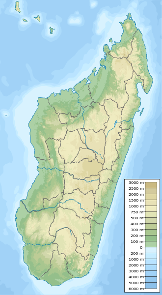
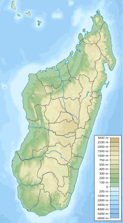
| Description | English: Physical map of Madagascar, parameters equal to Madagascar location map.svg. |
| Date | |
| Source | Own work |
| Author | Urutseg |
| SVG development |
Licensing
| I, the copyright holder of this work, release this work into the public domain. This applies worldwide. In some countries this may not be legally possible; if so: I grant anyone the right to use this work for any purpose, without any conditions, unless such conditions are required by law. |
File history
Click on a date/time to view the file as it appeared at that time.
| Date/Time | Thumbnail | Dimensions | User | Comment | |
|---|---|---|---|---|---|
| current | 23:09, 12 May 2023 | | 426 × 774 (2.2 MB) | GrandEscogriffe | adding two region borders: Atsinanana/Analanjirofo and Vatovavy-Fitovinany |
| 19:02, 11 October 2013 |  | 426 × 774 (2.17 MB) | NordNordWest | upd | |
| 19:26, 13 February 2011 |  | 426 × 774 (2.76 MB) | Urutseg | {{Information |Description ={{en|1=Physical map of Madagascar, parameters equal to File:Madagascar location map.svg.}} |Source ={{own}} |Author =Urutseg |Date =2011-02-13 |Permission = |other_version |
File usage
There are no pages that use this file.
Global file usage
The following other wikis use this file:
- Usage on ar.wikipedia.org
- Usage on arz.wikipedia.org
- Usage on ast.wikipedia.org
- Usage on azb.wikipedia.org
- Usage on az.wikipedia.org
- Usage on ban.wikipedia.org
- Usage on ba.wikipedia.org
- Usage on be.wikipedia.org
- Usage on bg.wikipedia.org
- Антананариву
- Шаблон:ПК Мадагаскар
- Амбухиджананджиана
- Царахуненана Саханивучи
- Алакамизи
- Амбану
- Амбатумена
- Амбухибари
- Амбухимиариву
- Амбухициманува
- Анджануманелача
- Антанамбао
- Антаниманджи
- Анцирабе
- Манджусухасина
- Анцоатани
- Белазао
- Винанинкарена
- Манандуна
- Мангарану
- Соанинджарини
- Амбатунджакалавао
- Амбатулямпи
- Бетафо
- Алакамиси Анативату
- Аларубия Бемаха
- Амбатуникунилахи
View more global usage of this file.
Metadata
Explore the world

United states
New York

Japan
Tokyo

Singapore
Singapore
