
 Français
 Italiano
Size of this PNG preview of this SVG file: 800 × 422 pixels. Other resolutions: 320 × 169 pixels | 640 × 338 pixels | 1,024 × 541 pixels | 1,280 × 676 pixels | 2,560 × 1,352 pixels | 2,500 × 1,320 pixels.
Original file (Animated SVG file, nominally 2,500 × 1,320 pixels, file size: 219 KB)
Note: Due to technical limitations, thumbnails of this file will not be animated.
This is a file from the Wikimedia Commons and may be used by other projects. Information from its description page there is shown below. Commons is a freely licensed media file repository. |
Summary
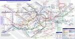
| Description | English: Route map of London Underground, London Overground, Docklands Light Railway and Elizabeth line (Crossrail), including most green-lighted proposals. Information of the zonal system and route validators can be turned off by clicking/tapping the upper-left button. Other interactive functions are identical to the original version. | |||
| Date | ||||
| Source | Own work | |||
| Author | Sameboat | |||
| Permission (Reusing this file) | I, the copyright holder of this work, hereby publish it under the following license: This file is licensed under the Creative Commons Attribution-Share Alike 4.0 International license.
| |||
| Other versions |
| |||
| SVG development | This map was created with an unknown SVG tool. |

This vector image was created with a text editor.
Please do not replace the simplified code of this file with a version created with Inkscape or any other vector graphics editor
 | This image is an animated SVG file. The .png preview above created by RSVG for use in Wikimedia is not animated and may be incomplete or incorrect. To see the animation, open media:London Underground Overground DLR Crossrail map zone.svg. It should run in any modern browser or viewer. Recent versions of Chrome, Firefox, Microsoft Edge, Safari, and Opera all support SVG animated with SMIL. Other SVG animations can be found at Category:Animated SVG files.
|
File history
Click on a date/time to view the file as it appeared at that time.
| Date/Time | Thumbnail | Dimensions | User | Comment | |
|---|---|---|---|---|---|
| current | 06:28, 25 March 2024 | | 2,500 × 1,320 (219 KB) | Sameboat | change OOC icon to NR |
| 06:22, 23 March 2024 |  | 2,500 × 1,320 (219 KB) | Sameboat | restore changes made by The wub and Jc86035 | |
| 06:17, 23 March 2024 |  | 2,500 × 1,320 (219 KB) | Sameboat | + Old Oak Common | |
| 23:17, 19 March 2024 |  | 2,500 × 1,320 (219 KB) | The wub | Update cable car, add tooltip for Woolwich/Woolwich Arsenal interchange | |
| 21:59, 19 February 2024 |  | 2,500 × 1,320 (219 KB) | Jc86035 | Wandsworth Road | |
| 01:09, 19 February 2024 |  | 2,500 × 1,320 (219 KB) | Sameboat | ||
| 14:43, 16 February 2024 |  | 2,500 × 1,320 (219 KB) | Sameboat | ||
| 14:36, 16 February 2024 |  | 2,500 × 1,320 (219 KB) | Sameboat | overground new names and new colors | |
| 06:03, 7 November 2022 |  | 2,500 × 1,320 (221 KB) | Sameboat | Pudding Mill Lane portal | |
| 05:19, 6 November 2022 |  | 2,500 × 1,320 (223 KB) | Sameboat | Elizabeth line thru Paddington |
File usage
The following 2 pages use this file:
Global file usage
The following other wikis use this file:
- Usage on ca.wikipedia.org
- Usage on en.wikipedia.org
- Usage on ko.wikipedia.org
- Usage on www.wikidata.org
- Usage on zh.wikipedia.org
Metadata
Explore the world

United states
New York

Japan
Tokyo

Singapore
Singapore
