
 Français
 Italiano
Size of this preview: 800 × 544 pixels. Other resolutions: 320 × 217 pixels | 640 × 435 pixels | 1,024 × 696 pixels | 1,280 × 870 pixels | 3,001 × 2,039 pixels.
Original file (3,001 × 2,039 pixels, file size: 1.07 MB, MIME type: image/png)
This is a file from the Wikimedia Commons and may be used by other projects. Information from its description page there is shown below. Commons is a freely licensed media file repository. |
Summary
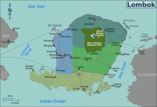
| Description | Map of Lombok (Indonesia) with touristic regions, for use on Wikivoyage, English version |
| Date | 29 March 2010, updated on 19 November 2012 |
| Source | Own work based on OpenStreetMap |
| Author | Burmesedays, amendments by Felix505 |
| Other versions |
.png)
Licensing
This file is licensed under the Creative Commons Attribution-Share Alike 3.0 Unported license.
- You are free:
- to share – to copy, distribute and transmit the work
- to remix – to adapt the work
- Under the following conditions:
- attribution – You must give appropriate credit, provide a link to the license, and indicate if changes were made. You may do so in any reasonable manner, but not in any way that suggests the licensor endorses you or your use.
- share alike – If you remix, transform, or build upon the material, you must distribute your contributions under the same or compatible license as the original.
Original upload log
| This file was imported from Wikivoyage WTS. |
The original description page was here. All following user names refer to wts.wikivoyage-old.
- 2010-03-29 14:08 (WT-shared) Burmesedays[dead link] 3001×2039 (1155796 bytes) {{Imagecredit|credit=[[User:Burmesedays]],[http://openstreetmap.org OpenStreetMap]|captureDate=29 March 2010|location=Lombok|source=[[:Image (Import from wikitravel.org/shared)
- 2010-03-31 15:41 (WT-shared) Burmesedays[dead link] 3001×2039 (1152082 bytes) fixed water pattern gridline issue (I always forget this) (Import from wikitravel.org/shared)
File history
Click on a date/time to view the file as it appeared at that time.
| Date/Time | Thumbnail | Dimensions | User | Comment | |
|---|---|---|---|---|---|
| current | 01:50, 15 December 2012 | | 3,001 × 2,039 (1.07 MB) | OgreBot | (BOT): Reverting to most recent version before archival |
| 01:50, 15 December 2012 |  | 3,001 × 2,039 (1.1 MB) | OgreBot | (BOT): Uploading old version of file from wts.wikivoyage; originally uploaded on 2010-03-29 14:08:23 by (WT-shared) Burmesedays | |
| 10:59, 19 November 2012 |  | 3,001 × 2,039 (1.07 MB) | Felix505 | Move airport locator icon from AMI to LOP. AMI closed on 30 September 2011, LOP opened on 1 October 2011 Slights modification applied to nearby highway to indicate deviation to new airport, other details remain unchanged Modifications applied by [[User... | |
| 00:39, 18 November 2012 |  | 3,001 × 2,039 (1.1 MB) | MGA73bot2 | {{BotMoveToCommons|wts.oldwikivoyage|year={{subst:CURRENTYEAR}}|month={{subst:CURRENTMONTHNAME}}|day={{subst:CURRENTDAY}}}} == {{int:filedesc}} == {{Information |description=Map of Lombok. Map of Lombok with regions colour coded; English version, Lombo... |
File usage
The following 4 pages use this file:
Global file usage
The following other wikis use this file:
- Usage on ceb.wikipedia.org
- Usage on de.wikivoyage.org
- Usage on incubator.wikimedia.org
- Usage on it.wikivoyage.org
- Usage on nl.wikivoyage.org
- Usage on pt.wikivoyage.org
- Usage on sv.wikipedia.org
Metadata
Explore the world

United states
New York

Japan
Tokyo

Singapore
Singapore
