
 Français
 Italiano
Size of this PNG preview of this SVG file: 505 × 600 pixels. Other resolutions: 202 × 240 pixels | 404 × 480 pixels | 647 × 768 pixels | 862 × 1,024 pixels | 1,725 × 2,048 pixels | 1,099 × 1,305 pixels.
Original file (SVG file, nominally 1,099 × 1,305 pixels, file size: 3.32 MB)
This is a file from the Wikimedia Commons and may be used by other projects. Information from its description page there is shown below. Commons is a freely licensed media file repository. |
Summary
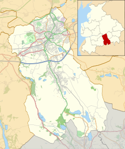
| Description | English: Map of the Borough of Blackburn with Darwen, Lancashire, England. Equirectangular map projection on WGS 84 datum, with N/S stretched 165% Geographic limits:
|
| Date | |
| Source | This file was derived from: Blackburn with Darwen UK ward map 2010 (blank).svg: |
| Author |
|
.svg)
Licensing
| This work contains information from OpenStreetMap, which is made available under the Open Database License (ODbL). The ODbL does not require any particular license for maps produced from ODbL data. Prior to 1 August 2020, map tiles produced by the OpenStreetMap Foundation were licensed under the CC-BY-SA-2.0 license. Maps produced by other people may be subject to other licences. |
This file is licensed under the Creative Commons Attribution-Share Alike 2.0 Generic license.
Attribution: © OpenStreetMap contributors. Contains Ordnance Survey data © Crown copyright and database right 2012.
- You are free:
- to share – to copy, distribute and transmit the work
- to remix – to adapt the work
- Under the following conditions:
- attribution – You must give appropriate credit, provide a link to the license, and indicate if changes were made. You may do so in any reasonable manner, but not in any way that suggests the licensor endorses you or your use.
- share alike – If you remix, transform, or build upon the material, you must distribute your contributions under the same or compatible license as the original.
File history
Click on a date/time to view the file as it appeared at that time.
| Date/Time | Thumbnail | Dimensions | User | Comment | |
|---|---|---|---|---|---|
| current | 23:01, 2 August 2014 | | 1,099 × 1,305 (3.32 MB) | Dr Greg | User created page with UploadWizard |
File usage
There are no pages that use this file.
Global file usage
The following other wikis use this file:
- Usage on ar.wikipedia.org
- Usage on azb.wikipedia.org
- Usage on de.wikipedia.org
- Usage on en.wikipedia.org
- Blackburn
- Blackburn with Darwen
- Darwen
- Witton Country Park
- Winter Hill transmitting station
- Brownhill
- Winter Hill (North West England)
- Belmont, Lancashire
- Jubilee Tower
- Feniscowles
- Hollinshead Hall
- Tockholes
- Upper Roddlesworth Reservoir
- Guide, Lancashire
- North Turton
- Blackamoor, Lancashire
- Belthorn
- Edgworth
- Chapeltown, Lancashire
- Eccleshill, Lancashire
- Pleasington
- Bank Fold
- Bank Hey
- Beardwood
- Cadshaw
- Entwistle, Lancashire
- Lower Darwen
- Pleasington Priory
- Turton Tower
- Hoddlesden
- Little Harwood
- Cheetham Close
- Whalley Range, Blackburn
- Wayoh Reservoir
- Turton and Entwistle Reservoir
- Belmont Reservoir
- Ward's Reservoir
- Dingle Reservoir
- St Cuthbert's Church, Darwen
- Immanuel Church, Feniscowles
- St Barnabas' Church, Darwen
- St Peter's Church, Darwen
- Barley Bank
- Module:Location map/data/United Kingdom Blackburn with Darwen
- Module:Location map/data/United Kingdom Blackburn with Darwen/doc
View more global usage of this file.
Metadata
Explore the world

United states
New York

Japan
Tokyo

Singapore
Singapore
