
 Français
 Italiano
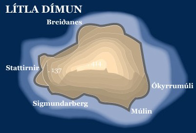
No higher resolution available.
Litla_dimun_map.jpg (401 × 273 pixels, file size: 21 KB, MIME type: image/jpeg)
This is a file from the Wikimedia Commons and may be used by other projects. Information from its description page there is shown below. Commons is a freely licensed media file repository. |
- Topopgraphic map of the island of Lítla Dímun, Faroe Islands
- Graphics: Anker Eli Petersen
- Source: Faroestamps.fo
| This work has been released into the public domain by its copyright holder, Postverk Føroya - Philatelic Office. This applies worldwide. In some countries this may not be legally possible; if so: Postverk Føroya - Philatelic Office grants anyone the right to use this work for any purpose, without any conditions, unless such conditions are required by law.
|
File history
Click on a date/time to view the file as it appeared at that time.
| Date/Time | Thumbnail | Dimensions | User | Comment | |
|---|---|---|---|---|---|
| current | 08:28, 28 June 2005 | | 401 × 273 (21 KB) | Arne List | *Topopgraphic map of the island of Lítla Dímun, Faroe Islands *Graphics: Anker Eli Petersen *Source: [http://www.faroestamps.fo/?side=cf860f1610d1ec7342844c79d9ddd36e Faroestamps.fo] {{PD}} |
File usage
There are no pages that use this file.
Global file usage
The following other wikis use this file:
- Usage on ca.wikipedia.org
- Usage on cs.wikipedia.org
- Usage on da.wikipedia.org
- Usage on de.wikipedia.org
- Usage on el.wikipedia.org
- Usage on en.wikipedia.org
- Usage on eo.wikipedia.org
- Usage on es.wikipedia.org
- Usage on eu.wikipedia.org
- Usage on fa.wikipedia.org
- Usage on fr.wikipedia.org
- Usage on hu.wikipedia.org
- Usage on id.wikipedia.org
- Usage on it.wikipedia.org
- Usage on nl.wikipedia.org
- Usage on pl.wikipedia.org
- Usage on pt.wikipedia.org
- Usage on ro.wikipedia.org
- Usage on sr.wikipedia.org
- Usage on sv.wikipedia.org
- Usage on tr.wikipedia.org
- Usage on vi.wikipedia.org
- Usage on zh.wikipedia.org
Metadata
Explore the world

United states
New York

Japan
Tokyo

Singapore
Singapore
