
 Français
 Italiano
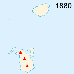
No higher resolution available.
Krakatoa_evolution_map-en.gif (250 × 250 pixels, file size: 43 KB, MIME type: image/gif, looped, 15 frames, 40 s)
This is a file from the Wikimedia Commons and may be used by other projects. Information from its description page there is shown below. Commons is a freely licensed media file repository. |
Summary
| Description | English: Evolution map in English of the Krakatoa's archipelago (Indonesia), between 1880 and 2005. The main eruption was in 1883. Español: Mapa, en inglés, de la evolución de el archipiélago Krakatoa (Indonesia), entre 1880 y 2005. La erupción principal fué en 1883. Français : Carte de l'évolution de l'archipel du Krakatoa (Indonésie), entre 1880 et 2005. L'éruption principale date de 1883. 日本語: クラカタウ群島(インドネシア)の1880年~2005年にかけての変遷地図。大噴火は1883年。(英語) |
| Date | |
| Source | This file was derived from: Krakatoa evolution map-fr.gif:  |
| Author |
|
| This is a retouched picture, which means that it has been digitally altered from its original version. Modifications: translated to English. The original can be viewed here: Krakatoa evolution map-fr.gif:
|
Licensing
I, the copyright holder of this work, hereby publish it under the following licenses:
This file is licensed under the Creative Commons Attribution-Share Alike 3.0 Unported, 2.5 Generic, 2.0 Generic and 1.0 Generic license.
- You are free:
- to share – to copy, distribute and transmit the work
- to remix – to adapt the work
- Under the following conditions:
- attribution – You must give appropriate credit, provide a link to the license, and indicate if changes were made. You may do so in any reasonable manner, but not in any way that suggests the licensor endorses you or your use.
- share alike – If you remix, transform, or build upon the material, you must distribute your contributions under the same or compatible license as the original.
 | Permission is granted to copy, distribute and/or modify this document under the terms of the GNU Free Documentation License, Version 1.2 or any later version published by the Free Software Foundation; with no Invariant Sections, no Front-Cover Texts, and no Back-Cover Texts. A copy of the license is included in the section entitled GNU Free Documentation License. |
You may select the license of your choice.
Original upload log
This image is a derivative work of the following images:
- File:Krakatoa_evolution_map-fr.gif licensed with Cc-by-sa-3.0,2.5,2.0,1.0, GFDL
- 2008-04-24T08:33:25Z Sémhur 250x250 (42324 Bytes) == Description == {{Information |Description= {{en|Evolution map in French of the [[:en:Krakatoa|Krakatoa]]'s archipelago (Indonesia), between 1880 and 2005. The main eruption was in 1883.}} {{fr|Carte de l'évolution de l'ar
Uploaded with derivativeFX
File history
Click on a date/time to view the file as it appeared at that time.
| Date/Time | Thumbnail | Dimensions | User | Comment | |
|---|---|---|---|---|---|
| current | 22:42, 28 May 2022 | | 250 × 250 (43 KB) | Italyoz484 | 2018 update |
| 09:58, 11 April 2012 |  | 250 × 250 (40 KB) | Morn | == {{int:filedesc}} == {{Information |Description={{en|Evolution map in French of the Krakatoa's archipelago (Indonesia), between 1880 and 2005. The main eruption was in 1883.}} {{fr|Carte de l'évolution de l'archipel du [[:fr:Krakato... |
File usage
There are no pages that use this file.
Global file usage
The following other wikis use this file:
- Usage on ar.wikipedia.org
- Usage on az.wikipedia.org
- Usage on bcl.wikipedia.org
- Usage on bs.wikipedia.org
- Usage on cs.wikipedia.org
- Usage on de.wikipedia.org
- Usage on el.wikipedia.org
- Usage on en.wikipedia.org
- Usage on gl.wikipedia.org
- Usage on id.wikipedia.org
- Usage on it.wikipedia.org
- Usage on it.wikibooks.org
- Usage on ja.wikipedia.org
- Usage on ka.wikipedia.org
- Usage on mk.wikipedia.org
- Usage on pt.wikipedia.org
- Usage on ro.wikipedia.org
- Usage on ru.wikipedia.org
- Usage on su.wikipedia.org
- Usage on th.wikipedia.org
- Usage on uk.wikipedia.org
- Usage on xh.wikipedia.org
Metadata
Explore the world

United states
New York

Japan
Tokyo

Singapore
Singapore
