
 Français
 Italiano
Size of this preview: 576 × 599 pixels. Other resolutions: 231 × 240 pixels | 461 × 480 pixels | 738 × 768 pixels | 984 × 1,024 pixels | 1,840 × 1,915 pixels.
Original file (1,840 × 1,915 pixels, file size: 2.08 MB, MIME type: image/png)
This is a file from the Wikimedia Commons and may be used by other projects. Information from its description page there is shown below. Commons is a freely licensed media file repository. |
Summary
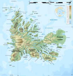
| Description | English: Topographic map of the Kerguelen Islands, Indian Ocean, France. Use the SVG version for translations and correcting mistakes. Français : Carte topographique des îles Kerguelen. Utiliser la version SVG pour les traductions et corrections.
|
| Date | |
| Source | Own work. Sources of data:
|
| Author | Rémi Kaupp |
| Other versions | []
|


Licensing
English: This map has been created by Rémi Kaupp (User:Korrigan) and released under the license(s) stated below. You are free to use it for any purpose as long as you credit me and follow the terms of the license. You may need to credit the sources of data of the map (please check). Example: Français : Cette carte a été créée par Rémi Kaupp (User:Korrigan) et placée sous la ou les licence(s) ci-dessous. Vous êtes libre de la réutiliser, tant que vous me citez en tant qu'auteur et suivez les instructions de la licence. Certaines sources de données de la carte doivent peut-être être créditées, veuillez vérifier. Exemple : |  |
I, the copyright holder of this work, hereby publish it under the following licenses:
 | Permission is granted to copy, distribute and/or modify this document under the terms of the GNU Free Documentation License, Version 1.2 or any later version published by the Free Software Foundation; with no Invariant Sections, no Front-Cover Texts, and no Back-Cover Texts. A copy of the license is included in the section entitled GNU Free Documentation License. |
This file is licensed under the Creative Commons Attribution-Share Alike 4.0 International, 3.0 Unported, 2.5 Generic, 2.0 Generic and 1.0 Generic license.
- You are free:
- to share – to copy, distribute and transmit the work
- to remix – to adapt the work
- Under the following conditions:
- attribution – You must give appropriate credit, provide a link to the license, and indicate if changes were made. You may do so in any reasonable manner, but not in any way that suggests the licensor endorses you or your use.
- share alike – If you remix, transform, or build upon the material, you must distribute your contributions under the same or compatible license as the original.
You may select the license of your choice.
File history
Click on a date/time to view the file as it appeared at that time.
| Date/Time | Thumbnail | Dimensions | User | Comment | |
|---|---|---|---|---|---|
| current | 14:13, 25 April 2010 | | 1,840 × 1,915 (2.08 MB) | Korrigan | Correcting roads after advice from B.navez |
| 21:02, 17 March 2009 |  | 1,840 × 1,915 (2.08 MB) | Korrigan | Typo ("prequ'île") | |
| 19:45, 17 March 2009 |  | 1,840 × 1,915 (2.08 MB) | Korrigan | {{Information |Description={{en|Topographic map of the Kerguelen Islands, Indian Ocean, France. Use the SVG version for translations and correcting mistakes.}} {{fr|Carte topographique des îles Kerguelen. Utilis |
File usage
There are no pages that use this file.
Global file usage
The following other wikis use this file:
- Usage on avk.wikipedia.org
- Usage on az.wikipedia.org
- Usage on br.wikipedia.org
- Usage on ca.wikipedia.org
- Usage on en.wikipedia.org
- Kerguelen Islands
- Port-aux-Français
- Cook Ice Cap
- Mont Ross
- Île Saint-Lanne Gramont
- Île Foch
- Îles de Boynes
- Courbet Peninsula
- Golfe du Morbihan (Kerguelen)
- Rallier du Baty Peninsula
- Baie Norvégienne
- Péninsule Jeanne d'Arc
- Loranchet Peninsula
- Baie Larose
- Îles Leygues
- Îles Nuageuses
- Lac Marville
- Île du Port
- Île de l'Ouest
- Île Longue (Kerguelen Islands)
- Île Haute
- Îles du Prince-de-Monaco
- Île Altazin
- Île Gaby
- Lake Armor
- Volcan du Diable
- Baie de l'Oiseau
- Kerguelen Arch
- Île de Croÿ
- Port-Christmas
- Mont Crozier
- Template:Navbox Kerguelen Islands
- Toponymy of the Kerguelen Islands
- Usage on es.wikipedia.org
- Usage on fr.wikipedia.org
View more global usage of this file.
Explore the world

United states
New York

Japan
Tokyo

Singapore
Singapore
