
 Français
 Italiano
Size of this preview: 764 × 600 pixels. Other resolutions: 306 × 240 pixels | 612 × 480 pixels | 978 × 768 pixels | 1,280 × 1,005 pixels | 1,498 × 1,176 pixels.
Original file (1,498 × 1,176 pixels, file size: 336 KB, MIME type: image/png)
This is a file from the Wikimedia Commons and may be used by other projects. Information from its description page there is shown below. Commons is a freely licensed media file repository. |
Summary
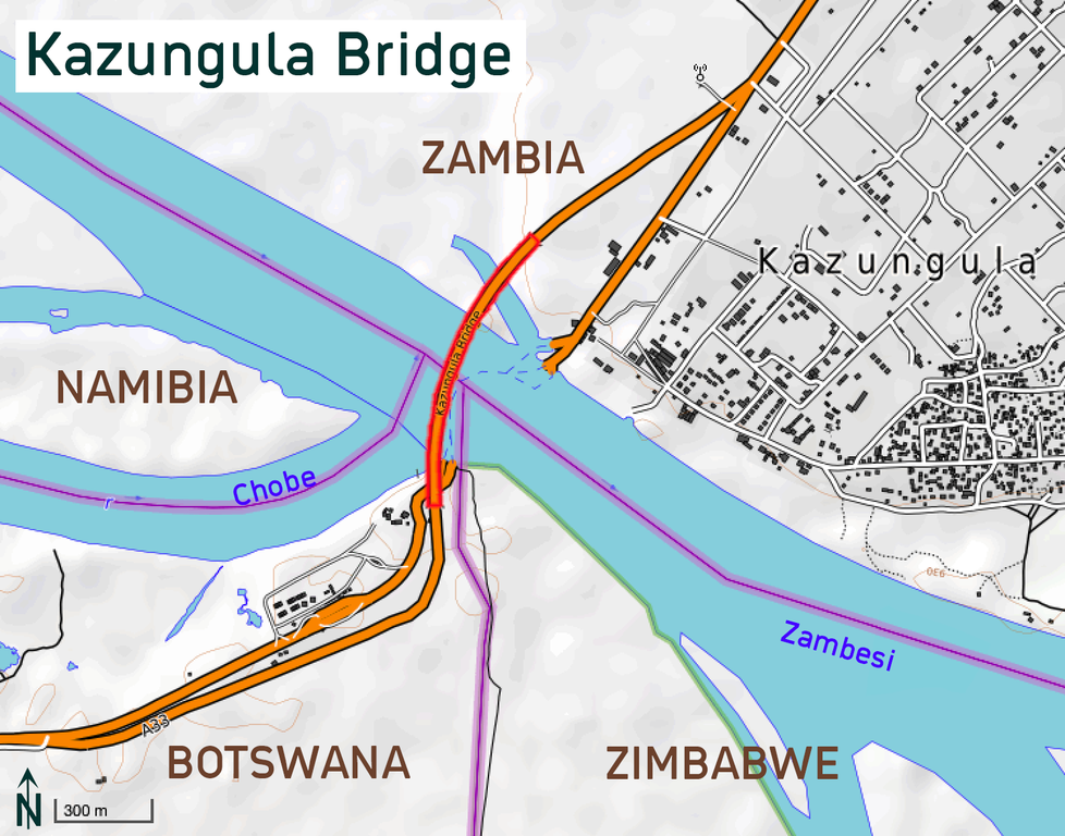
| Description | Kazungula Bridge (completed in 2020) in Botswana/Zambia This map of Kazungula was created from OpenStreetMap project data, collected by the community. This map may be incomplete, and may contain errors. Don't rely solely on it for navigation. | |||||||||
| Date | ||||||||||
| Source | You may find a page on the OpenStreetMap wiki page for OpenTopoMap | |||||||||
| Creator | Map design: OpenTopoMap; User:Albinfo OpenStreetMap contributors | |||||||||
| Permission (Reusing this file) | OpenStreetMap data is available under the Open Database License (details). Map tiles are licensed under the Creative Commons Attribution-ShareAlike 2.0 license (CC-BY-SA 2.0).
This file is licensed under the Creative Commons Attribution-Share Alike 2.0 Generic license.
| |||||||||
| Geotemporal data | ||||||||||
| Bounding box |
| |||||||||
| Georeferencing | If inappropriate please set warp_status = skip to hide. | |||||||||
File history
Click on a date/time to view the file as it appeared at that time.
| Date/Time | Thumbnail | Dimensions | User | Comment | |
|---|---|---|---|---|---|
| current | 15:29, 16 November 2020 | | 1,498 × 1,176 (336 KB) | Albinfo | small fix |
| 15:27, 16 November 2020 |  | 1,498 × 1,176 (337 KB) | Albinfo | {{OpenStreetMap |name = OpenTopoMap |location = Kazungula |description = Kazungula Bridge (completed in 2020) in Botswana/Zambia |top = -17.7803 |bottom = -17.8049 |left = 25.24897 |right = 25.28104 |date = 2020 |authors = Map design: OpenTopoMap; User:Albinfo |other_versions = |warp_status = |warp_url = |odbl = |other_fields = }} Category:Kazungula Bridge [[Category:OpenStreet... |
File usage
There are no pages that use this file.
Global file usage
The following other wikis use this file:
- Usage on de.wikipedia.org
- Usage on en.wikipedia.org
- Usage on eu.wikipedia.org
- Usage on fi.wikipedia.org
- Usage on fr.wikipedia.org
- Usage on hr.wikipedia.org
- Usage on ja.wikipedia.org
- Usage on nl.wikipedia.org
- Usage on pl.wikipedia.org
- Usage on sl.wikipedia.org
- Usage on sv.wikipedia.org
- Usage on tn.wikipedia.org
- Usage on uk.wikipedia.org
- Usage on www.wikidata.org
Metadata
Explore the world

United states
New York

Japan
Tokyo

Singapore
Singapore
