
 Français
 Italiano
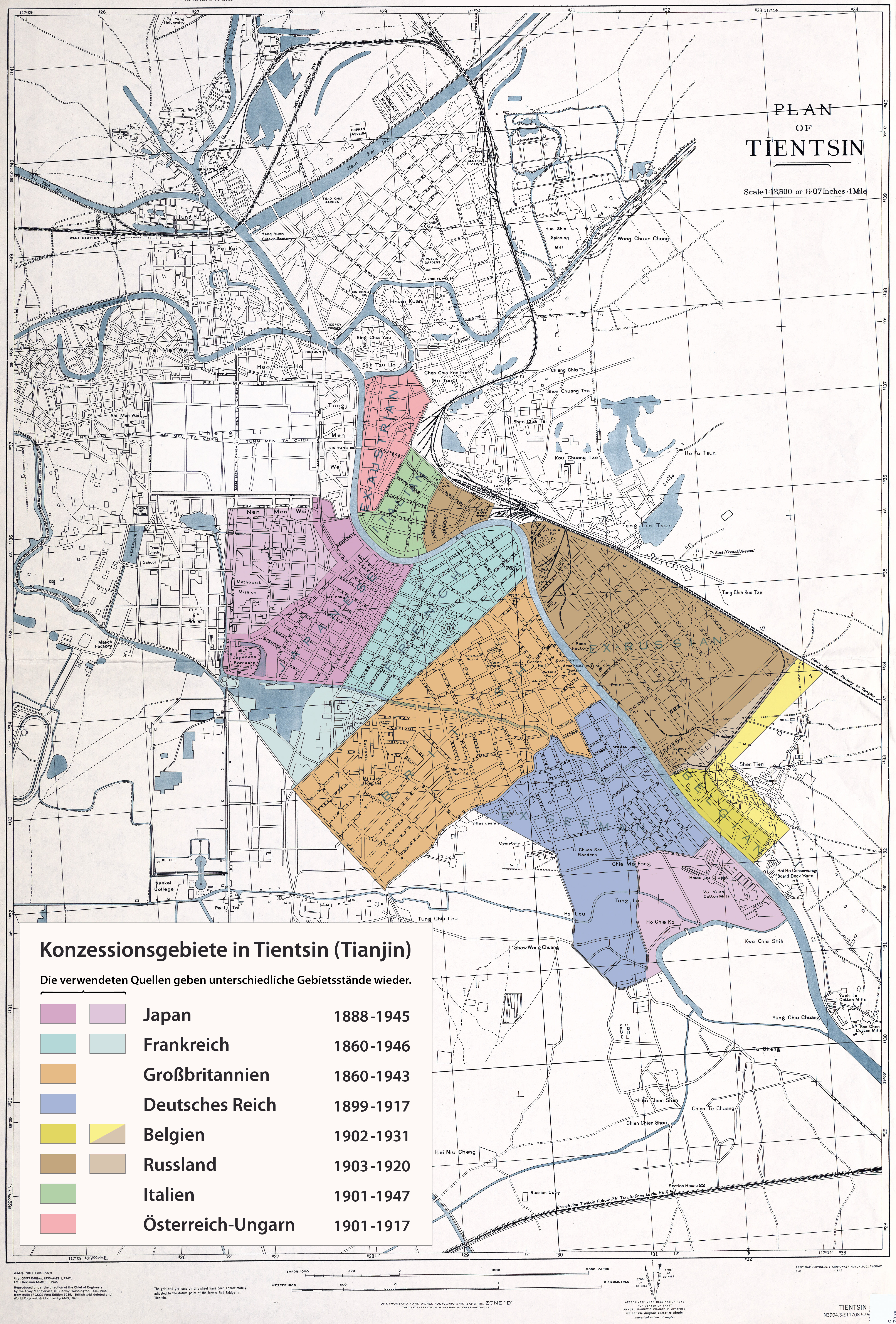
Original file (4,117 × 6,081 pixels, file size: 9.55 MB, MIME type: image/jpeg)
This is a file from the Wikimedia Commons and may be used by other projects. Information from its description page there is shown below. Commons is a freely licensed media file repository. |
Summary
|Description =
|Source=Own work, using this map from 1942 as background.
Sources for the concession areas:
- 1902(?) Map of Tianjin (Chinese version)
- 1902 Map of Tianjin (Western version)
- 1912 T'ien-chin - The Settlements Map
- 1941 Peiyang Map
- 1942 British War Office / US Army Map Service Map
|Date = see file history |Author = Maximilian Dörrbecker (Chumwa)
|Permission =
- You are free:
- to share – to copy, distribute and transmit the work
- to remix – to adapt the work
- Under the following conditions:
- attribution – You must give appropriate credit, provide a link to the license, and indicate if changes were made. You may do so in any reasonable manner, but not in any way that suggests the licensor endorses you or your use.
- share alike – If you remix, transform, or build upon the material, you must distribute your contributions under the same or compatible license as the original.
| This work contains information from OpenStreetMap, which is made available under the Open Database License (ODbL). The ODbL does not require any particular license for maps produced from ODbL data. Prior to 1 August 2020, map tiles produced by the OpenStreetMap Foundation were licensed under the CC-BY-SA-2.0 license. Maps produced by other people may be subject to other licences. |
Sie dürfen das Bild zu den folgenden Bedingungen nutzen:
- Sie müssen den Namen des Autors nennen.
- Im Falle einer Verbreitung müssen Sie anderen die Lizenzbedingungen, unter die dieses Bild fällt, mitteilen.
- Sie müssen das Bild unter gleichen Bedingungen weitergeben. Wenn sie das Bild abändern oder Arbeiten auf diesem Bild aufbauen, müssen Sie das Ergebnis aus dieser Arbeit ebenfalls unter diese Lizenz stellen.
- Jede dieser Bedingungen kann nach schriftlicher Einwilligung des Rechtsinhabers aufgehoben werden.
|other_versions = }}
File history
Click on a date/time to view the file as it appeared at that time.
| Date/Time | Thumbnail | Dimensions | User | Comment | |
|---|---|---|---|---|---|
| current | 21:01, 30 October 2013 | | 4,117 × 6,081 (9.55 MB) | Chumwa | ein "e"... |
| 19:22, 30 October 2013 |  | 4,117 × 6,081 (9.55 MB) | Chumwa | == {{int:filedesc}} == {{Information |Description = {{de|1=Karte der Konzessionsgebiete in Tientsin (Tianjin)}} |Source={{own}}, using this map from 1942 as background.<br> Sources for the concession areas: * [[:File:T... |
File usage
There are no pages that use this file.
Global file usage
The following other wikis use this file:
- Usage on ar.wikipedia.org
- Usage on ca.wikipedia.org
- Usage on cs.wikipedia.org
- Usage on de.wikipedia.org
- Tianjin
- Italienische Kolonien
- Belgische Kolonien
- Vertragshafen
- Benutzer:Chumwa
- Österreichische Kolonialpolitik
- Wikipedia Diskussion:Kartenwerkstatt/Archiv6
- Wikipedia:Kartenwerkstatt/Archiv/2013-11
- Wikipedia:Kartenwerkstatt/Karte des Tages/Galerie
- Benutzer:Chumwa/SomeOfMyFiles
- Italienische Konzession von Tientsin
- Österreichisch-ungarische Konzession in Tientsin
- Deutsche Konzession in Tientsin
- Usage on de.wikivoyage.org
- Usage on en.wikipedia.org
- Usage on en.wikiquote.org
- Usage on fr.wikipedia.org
- Usage on he.wikipedia.org
- Usage on hu.wikipedia.org
- Usage on hu.wikibooks.org
- Usage on it.wikipedia.org
- Usage on ja.wikipedia.org
- Usage on lmo.wikipedia.org
- Usage on nl.wikipedia.org
- Usage on pt.wikipedia.org
- Usage on ru.wikipedia.org
- Usage on vi.wikipedia.org
- Usage on zh.wikipedia.org
Metadata
Explore the world

United states
New York

Japan
Tokyo

Singapore
Singapore
