
 Français
 Italiano
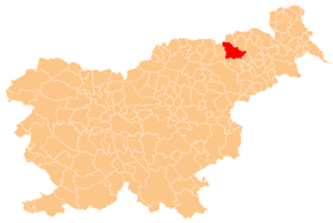
No higher resolution available.
Karte_Maribor_si.png (300 × 201 pixels, file size: 43 KB, MIME type: image/png)
This is a file from the Wikimedia Commons and may be used by other projects. Information from its description page there is shown below. Commons is a freely licensed media file repository. |
Summary
| Description | Deutsch: Karte der Gemeinde Maribor in Slowenien. English: Localization of Maribor in Slovenia. |
| Source | Own work |
| Author | Deutsch: Hergestellt vom Benutzer Plp der slowenischen Wikipedia. English: Creator Plp |
 | Permission is granted to copy, distribute and/or modify this document under the terms of the GNU Free Documentation License, Version 1.2 or any later version published by the Free Software Foundation; with no Invariant Sections, no Front-Cover Texts, and no Back-Cover Texts. A copy of the license is included in the section entitled GNU Free Documentation License. |
| This file is licensed under the Creative Commons Attribution-Share Alike 3.0 Unported license. | ||
| ||
| This licensing tag was added to this file as part of the GFDL licensing update. |
File history
Click on a date/time to view the file as it appeared at that time.
| Date/Time | Thumbnail | Dimensions | User | Comment | |
|---|---|---|---|---|---|
| current | 02:16, 19 July 2005 | | 300 × 201 (43 KB) | Besednjak~commonswiki | Karte der Gemeinde Maribor in Slowenien. Hergestellt von Benutzer Plp der sl.wikipedia. {{GFDL}} |
File usage
There are no pages that use this file.
Global file usage
The following other wikis use this file:
- Usage on ar.wikipedia.org
- Usage on arz.wikipedia.org
- Usage on ast.wikipedia.org
- Usage on ba.wikipedia.org
- Usage on bg.wikipedia.org
- Шаблон:Община Марибор
- Брестерница
- Марибор (община)
- Винаре (община Марибор)
- Водоле
- Върхов Дол
- Гай над Марибором
- Грушова (Словения)
- Догоше
- Еловец (община Марибор)
- За Калварийо
- Згорни Слемен (община Марибор)
- Зърковци
- Камница (община Марибор)
- Кошаки
- Лазница (община Марибор)
- Лимбуш
- Малечник
- Мелски Хриб
- Метава
- Небова
- Пекел (община Марибор)
- Пекре
- Почехова
- Разване
- Рибнишко село
- Рошпох (община Марибор)
- Руперче
- Средне
- Търчова
- Храсте (община Марибор)
- Хренца
- Целестрина
- Шобер
- Usage on ca.wikipedia.org
- Usage on ceb.wikipedia.org
- Usage on cs.wikipedia.org
- Usage on de.wikipedia.org
- Usage on el.wikipedia.org
- Usage on en.wikipedia.org
View more global usage of this file.
Explore the world

United states
New York

Japan
Tokyo

Singapore
Singapore
