
 Français
 Italiano
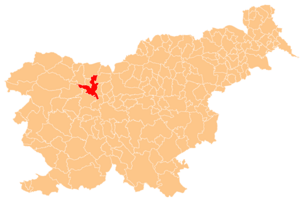
No higher resolution available.
Karte_Kranj_si.png (300 × 201 pixels, file size: 43 KB, MIME type: image/png)
This is a file from the Wikimedia Commons and may be used by other projects. Information from its description page there is shown below. Commons is a freely licensed media file repository. |
Deutsch: Karte der Gemeinde Kranj in Slowenien. Hergestellt vom Benutzer Plp der slowenischen Wikipedia.
English: Localization of Kranj in Slovenia. Creator Plp
 | Permission is granted to copy, distribute and/or modify this document under the terms of the GNU Free Documentation License, Version 1.2 or any later version published by the Free Software Foundation; with no Invariant Sections, no Front-Cover Texts, and no Back-Cover Texts. A copy of the license is included in the section entitled GNU Free Documentation License. |
| This file is licensed under the Creative Commons Attribution-Share Alike 3.0 Unported license. | ||
| ||
| This licensing tag was added to this file as part of the GFDL licensing update. |
File history
Click on a date/time to view the file as it appeared at that time.
| Date/Time | Thumbnail | Dimensions | User | Comment | |
|---|---|---|---|---|---|
| current | 02:18, 19 July 2005 | | 300 × 201 (43 KB) | Besednjak~commonswiki | Karte der Gemeinde Kranj in Slowenien. Hergestellt von Benutzer Plp der sl.wikipedia. {{GFDL}} |
File usage
There are no pages that use this file.
Global file usage
The following other wikis use this file:
- Usage on cs.wikipedia.org
- Usage on de.wikipedia.org
- Usage on en.wikipedia.org
- France Prešeren
- Kranj
- Simon Jenko
- Marko Pogačnik
- Boštjan Hladnik
- Podreča
- Davorin Dolar
- User:Husond/Gallery/Slovenia
- Template:Kranj
- Babni Vrt
- Bobovek
- Breg ob Savi
- Britof
- Golnik
- Hrastje, Kranj
- Ilovka
- Jama, Kranj
- Jamnik, Kranj
- Javornik, Kranj
- Kokrica
- Lavtarski Vrh
- Letenice
- Meja, Kranj
- Mlaka pri Kranju
- Nemilje
- Njivica
- Orehovlje, Kranj
- Planica, Kranj
- Podblica
- Povlje
- Predoslje
- Rakovica, Kranj
- Spodnja Besnica
- Spodnje Bitnje
- Srakovlje
- Srednja Vas–Goriče
- Srednje Bitnje
- Suha pri Predosljah
- Tatinec
- Trstenik, Kranj
- Zabukovje, Kranj
- Zalog, Kranj
- Zgornja Besnica, Kranj
- Zgornje Bitnje
- Čadovlje, Kranj
- Čepulje
- Goriče, Kranj
- Mavčiče
View more global usage of this file.
Explore the world

United states
New York

Japan
Tokyo

Singapore
Singapore
