
 Français
 Italiano
Size of this PNG preview of this SVG file: 800 × 406 pixels. Other resolutions: 320 × 162 pixels | 640 × 325 pixels | 1,024 × 520 pixels | 1,280 × 650 pixels | 2,560 × 1,299 pixels | 940 × 477 pixels.
Original file (SVG file, nominally 940 × 477 pixels, file size: 1.56 MB)
This is a file from the Wikimedia Commons and may be used by other projects. Information from its description page there is shown below. Commons is a freely licensed media file repository. |
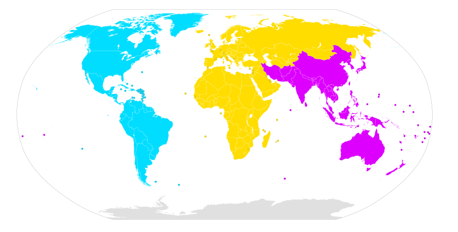
| Description | English: A map of the world divided into International Telecommunication Union regions. Français : Carte du monde divisée en 3 régions :
Українська: Карта світу, що поділена на регіони Міжнародного телекомунікаційного союзу. |
| Date | (UTC) |
| Source | |
| Author |
|
W3C-validity not checked.
| This is a retouched picture, which means that it has been digitally altered from its original version. Modifications: Added colouring based on ITU regions. The original can be viewed here: BlankMap-World6.svg:
|
I, the copyright holder of this work, hereby publish it under the following license:
| I, the copyright holder of this work, release this work into the public domain. This applies worldwide. In some countries this may not be legally possible; if so: I grant anyone the right to use this work for any purpose, without any conditions, unless such conditions are required by law. |
Original upload log
This image is a derivative work of the following images:
- File:BlankMap-World6.svg licensed with PD-self
- 2010-10-10T22:06:16Z Canuckguy 940x477 (1630991 Bytes) Reverted to version as of 02:01, 18 September 2010 (Neth. Antilles removed, Sint Maarten and Curacao added, Bonaire part of "nl")
- 2010-09-18T02:01:50Z Canuckguy 940x477 (1630802 Bytes) Reverted to version as of 01:03, 9 July 2010. New version to be used October 10, 2010
- 2010-09-18T02:01:03Z Canuckguy 940x477 (1630991 Bytes) version with Sint Maarten and Curacao added, Bonaire as part of Netherlands, and Netherlands Antilles removed. To be used starting October 10, 2010
- 2010-07-09T01:03:28Z NuclearVacuum 940x477 (1630802 Bytes) after thinking about it, I think "aa" is better for the ocean than "zz"
- 2010-07-07T21:49:57Z NuclearVacuum 940x477 (1630805 Bytes) Reverted to version as of 20:25, 7 July 2010
- 2010-07-07T21:49:26Z NuclearVacuum 940x477 (1629207 Bytes) Reverted to version as of 16:45, 25 June 2010
- 2010-07-07T21:48:28Z NuclearVacuum 940x477 (1630623 Bytes) Reverted to version as of 16:51, 29 June 2010 checking
- 2010-07-07T21:47:19Z NuclearVacuum 940x477 (1630506 Bytes) Reverted to version as of 14:49, 1 July 2010 checking something
- 2010-07-07T20:25:43Z NuclearVacuum 940x477 (1630805 Bytes) added marker for Swaziland
- 2010-07-07T19:43:09Z NuclearVacuum 940x477 (1630656 Bytes) added the European Union
- 2010-07-01T14:49:16Z NuclearVacuum 940x477 (1630506 Bytes) minor mistake
- 2010-07-01T14:47:13Z NuclearVacuum 940x477 (1630506 Bytes) Created code for the French Southern and Antarctic Lands.
- 2010-06-29T16:51:08Z NuclearVacuum 940x477 (1630623 Bytes) minor code cleanup
- 2010-06-28T22:28:48Z NuclearVacuum 940x477 (1630576 Bytes) new version taking into account the unrecognized nations and using user-assigned code.
- 2010-06-28T20:16:10Z NuclearVacuum 940x477 (1630640 Bytes) added separate class for unrecognized nations, minor cleanup
- 2010-06-28T20:00:16Z NuclearVacuum 940x477 (1630500 Bytes) checking again
- 2010-06-28T19:47:25Z NuclearVacuum 940x477 (1630500 Bytes) checking something
- 2010-06-28T18:57:05Z NuclearVacuum 940x477 (1630523 Bytes) Minor corrections involving lakes. Made a gap within South Africa where Lesotho should go.
- 2010-06-27T04:45:54Z NuclearVacuum 940x477 (1631933 Bytes) removed different coloring for Antarctica, as there is no real reason it should be in a different color, plus with the coloring changes recently made, the color used for Antarctica has no real difference.
- 2010-06-25T16:45:04Z Lokal Profil 940x477 (1629207 Bytes) Reverting to version from 17:47, April 18, 2010 but with Yug's colour change redone so as not to double the filesize (encoding seems to have changed)
- 2010-06-24T01:09:58Z NuclearVacuum 940x477 (3261014 Bytes) minor correction
- 2010-06-23T16:55:45Z NuclearVacuum 940x477 (3261008 Bytes) minor
- 2010-06-23T16:47:32Z NuclearVacuum 940x477 (3261004 Bytes) removed separate color for Antarctica, made space in South Africa where Lesotho goes.
- 2010-05-24T09:39:16Z Yug 940x477 (3263974 Bytes) Grey move : B9B9B9 to E0E0E0 according to wikipedia convention.
- 2010-04-18T16:47:05Z NuclearVacuum 940x477 (1631986 Bytes) minor
- 2010-04-17T18:50:55Z NuclearVacuum 940x477 (1631960 Bytes) fixed lakes of Alaska
- 2010-04-11T16:37:33Z NuclearVacuum 940x477 (1632024 Bytes) added the Nagorno-Karabakh Republic
- 2010-04-10T19:36:13Z NuclearVacuum 940x477 (1630753 Bytes) touched up Abkhazia and South Ossetia, added Pridnestrovie and Somaliland.
- 2010-01-02T20:38:23Z NuclearVacuum 940x477 (1630729 Bytes) Separated the South Georgia and South Sandwich Islands from the Falkland Islands (because they are two different entities). Also moved the Elephant Islands into Antarctica.
- 2009-11-27T19:47:29Z Lokal Profil 940x477 (1630524 Bytes) Minuscule fix to make northern Cyprus be coloured when Cyprus is coloured and Northern Cyprus isn't explicitly so.
- 2009-11-27T18:04:32Z NuclearVacuum 940x477 (1630535 Bytes) minor fix
- 2009-11-27T17:51:03Z NuclearVacuum 940x477 (1630539 Bytes) Added Northern Cyprus to the map using the method that Lokal Profil suggested.
- 2009-11-27T15:41:39Z NuclearVacuum 940x477 (1629682 Bytes) Fixed those ISO problems
- 2009-11-27T15:13:46Z Lokal Profil 940x477 (1626929 Bytes) Corrected ISO codes for areas included in fr and cn (leaving mainland fr as frx though)
- 2009-11-26T14:47:01Z NuclearVacuum 940x477 (1629733 Bytes) Minor mistake from previous version. I still used a word processor.
- 2009-11-26T14:45:14Z NuclearVacuum 940x477 (1629727 Bytes) Fixed some of the country codes using a word processor. This should be acceptable.
- 2009-11-26T10:44:47Z Lokal Profil 940x477 (1626926 Bytes) Reverted to version as of 00:38, 26 November 2009, newest upload reintoroduced some of the Inkscape junk code and broke the CSS classes in the US.
- 2009-11-26T02:23:41Z NuclearVacuum 940x477 (1676807 Bytes) fixed some code mistakes from reuploading, nothing major
- 2009-11-26T00:38:19Z Lokal Profil 940x477 (1626926 Bytes) Going back to revision from 21:17, October 15, 2009. Then removed lakes and added Norfolk Island and Tokelau. This should correct the misstakes in the class tags in the most recent uploads and remove the inkscape junk code.
- 2009-11-25T22:55:56Z NuclearVacuum 940x477 (1807366 Bytes) minor fixes
- 2009-11-21T23:01:58Z NuclearVacuum 940x477 (1812409 Bytes) border fixing
- 2009-11-21T20:51:00Z NuclearVacuum 940x477 (1766590 Bytes) minor again
- 2009-11-21T20:25:48Z NuclearVacuum 940x477 (1766605 Bytes) minor change
- 2009-11-21T18:21:05Z NuclearVacuum 940x477 (1765645 Bytes) Cleanup. The lakes are a good idea, but you erased the country code while doing it (re-added them). Also added the Norfolk Island and Tokelau to the map.
- 2009-11-13T18:48:11Z Ninjatacoshell 940x477 (1753679 Bytes) Recombined Alaska, Hawaii, and Mainland USA. Also, I converted the lakes to holes in their respective countries. See File Talk for more details.
- 2009-10-27T21:15:03Z NuclearVacuum 940x477 (1669323 Bytes) Separated Alaska and Hawaii from mainland USA.
- 2009-10-15T20:17:14Z Fibonacci 940x477 (1600338 Bytes) Copied path data from Kosovo, Abkhazia and South Ossetia onto the previous map.
- 2009-10-14T14:21:58Z NuclearVacuum 940x477 (1643397 Bytes) minor fix
- 2009-10-14T01:19:31Z NuclearVacuum 940x477 (1643265 Bytes) fixed up the borders of Kosovo, Abkhazia, and South Ossetia.
- 2009-10-12T05:43:31Z Fibonacci 940x477 (1600388 Bytes) Simplified code, fixed Georgia, changed circles into actual circles.
Uploaded with derivativeFX
File history
Click on a date/time to view the file as it appeared at that time.
| Date/Time | Thumbnail | Dimensions | User | Comment | |
|---|---|---|---|---|---|
| current | 04:03, 1 August 2011 | | 940 × 477 (1.56 MB) | Tokorokoko | a duplicate id="nl"=>"nlx". |
| 02:48, 20 October 2010 |  | 940 × 477 (1.56 MB) | Denelson83 | Dag-gone it! Forgot Timor-Leste! | |
| 08:22, 19 October 2010 |  | 940 × 477 (1.56 MB) | Denelson83 | {{Information |Description={{en|1=A map of the world divided into w:International Telecommunication Union regions.}} ---- {{ValidSVG}} |Source=*File:BlankMap-World6.svg |Date=2010-10-19 08:20 (UTC) |Author=*File:BlankMap-World6.svg: [[:en |
File usage
The following page uses this file:
Global file usage
The following other wikis use this file:
- Usage on af.wikipedia.org
- Usage on ar.wikipedia.org
- Usage on bn.wikivoyage.org
- Usage on ca.wikipedia.org
- Usage on da.wikipedia.org
- Usage on de.wikipedia.org
- Usage on en.wikipedia.org
- Usage on es.wikipedia.org
- Usage on fr.wikipedia.org
- Usage on fr.wikibooks.org
- Usage on it.wikivoyage.org
- Usage on mk.wikipedia.org
- Usage on pt.wikipedia.org
- Usage on sr.wikipedia.org
- Usage on sv.wikipedia.org
- Usage on zh.wikivoyage.org
Explore the world

United states
New York

Japan
Tokyo

Singapore
Singapore
