
 Français
 Italiano
Original file (SVG file, nominally 808 × 791 pixels, file size: 101 KB)
This is a file from the Wikimedia Commons and may be used by other projects. Information from its description page there is shown below. Commons is a freely licensed media file repository. |
Summary
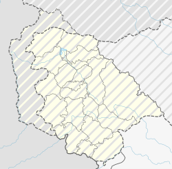
| Description | Deutsch: Positionskarte des Unionsterritoriums Jammu und Kashmir, Indien English: Location map of the Union Territory of Jammu and Kashmir, India
| ||||||||||||
| Date | |||||||||||||
| Source | Own work using:
| ||||||||||||
| Author | NordNordWest | ||||||||||||
 | This map has been made or improved in the German Kartenwerkstatt (Map Lab). You can propose maps to improve as well. |
Licensing
Usage of this file with:

explanatory notes: Legally binding is only the full legalcode. For a free usage I recommend to respect the following licence conditions:
1. Provide my name as given above: NordNordWest,
2. a copy of, or the URI for, the applicable license: https://creativecommons.org/licenses/by-sa/3.0/de/legalcode,
3. the title of the work,
4. in the case of an adaptation, a credit identifying the use of the work in the adaptation.
This license and the rights granted hereunder will terminate automatically upon any breach by you of the terms of this license. Any of the above conditions can be waived if you get permission from the copyright holder. If you have questions or wish differing conditions, please contact me through nnwest or my discussion page ![]() t-online.de
t-online.de
- You are free:
- to share – to copy, distribute and transmit the work
- to remix – to adapt the work
- Under the following conditions:
- attribution – You must give appropriate credit, provide a link to the license, and indicate if changes were made. You may do so in any reasonable manner, but not in any way that suggests the licensor endorses you or your use.
- share alike – If you remix, transform, or build upon the material, you must distribute your contributions under the same or compatible license as the original.

File history
Click on a date/time to view the file as it appeared at that time.
| Date/Time | Thumbnail | Dimensions | User | Comment | |
|---|---|---|---|---|---|
| current | 05:59, 22 July 2022 | | 808 × 791 (101 KB) | NordNordWest | Reverted to version as of 12:26, 21 July 2022 (UTC), please see COM:OVERWRITE |
| 05:53, 22 July 2022 |  | 757 × 741 (201 KB) | Crashed greek | Reverted to version as of 08:33, 21 July 2022 (UTC) | |
| 12:26, 21 July 2022 |  | 808 × 791 (101 KB) | NordNordWest | Reverted to version as of 18:46, 11 July 2022 (UTC), still disputed between India and Pakistan | |
| 08:33, 21 July 2022 |  | 757 × 741 (201 KB) | Crashed greek | Reverted to version as of 15:12, 11 July 2022 (UTC) Line of Control is recognised by UN | |
| 18:46, 11 July 2022 |  | 808 × 791 (101 KB) | NordNordWest | upd | |
| 16:35, 11 July 2022 |  | 808 × 791 (79 KB) | NordNordWest | Reverted to version as of 16:18, 5 November 2020 (UTC) J&K is disputed | |
| 15:12, 11 July 2022 |  | 757 × 741 (201 KB) | C1MM | Corrected positions of rivers and disticts. This map shows the de-facto situation, where India does not control Azad Kashmir or Gilgit-Baltistan and controls J&K and Ladakh. | |
| 16:18, 5 November 2020 |  | 808 × 791 (79 KB) | NordNordWest | corr | |
| 16:48, 11 November 2019 |  | 808 × 791 (84 KB) | NordNordWest | corr | |
| 18:00, 10 September 2019 |  | 1,191 × 1,276 (162 KB) | NordNordWest | == {{int:filedesc}} == {{Information |Description= {{de|1=Positionskarte des Unionsterritoriums Jammu und Kashmir, Indien}} {{en|1=Location map of the Union Territory of Jammu and Kashmir, India}} {{Location map series N |stretching=120 |top=37.2 |bottom=32.2 |left=72.4 |right=78.0 }} |Source={{Own using}} * United States National Imagery and Mapping Agency data * World Data Base II data |Date=2019-09-10 |Author={{U|NordNordWest}} |Permission= |other_versions= }} {{Kartenwerkstatt}} == {{int... |
File usage
There are no pages that use this file.
Global file usage
The following other wikis use this file:
- Usage on bh.wikipedia.org
- Usage on de.wikipedia.org
- Usage on en.wikipedia.org
- Usage on fr.wikipedia.org
- Srinagar
- Jardins de Shalimar (Cachemire)
- Modèle:Géolocalisation/Jammu-et-Cachemire
- Barrage de Baglihar
- Poonch
- Kathua
- Samba (Jammu-et-Cachemire)
- Kishtwar
- Badgam
- Ramban (Jammu-et-Cachemire)
- Ganderbal
- Bandipora
- Udhampur
- Anantnag
- Reasi
- Kulgam
- Rajauri
- Doda (Jammu-et-Cachemire)
- Kupwara
- Baramulla
- Shupiyan
- Pulwama
- Gulmarg
- Attentat de Pulwama
- Modèle:Géolocdual/Jammu-et-Cachemire
- Aéroport de Jammu
- Aéroport de Srinagar
- Usage on lv.wikipedia.org
- Usage on ta.wikipedia.org
- Usage on uk.wikipedia.org
Metadata
Explore the world

United states
New York

Japan
Tokyo

Singapore
Singapore
