
 Français
 Italiano
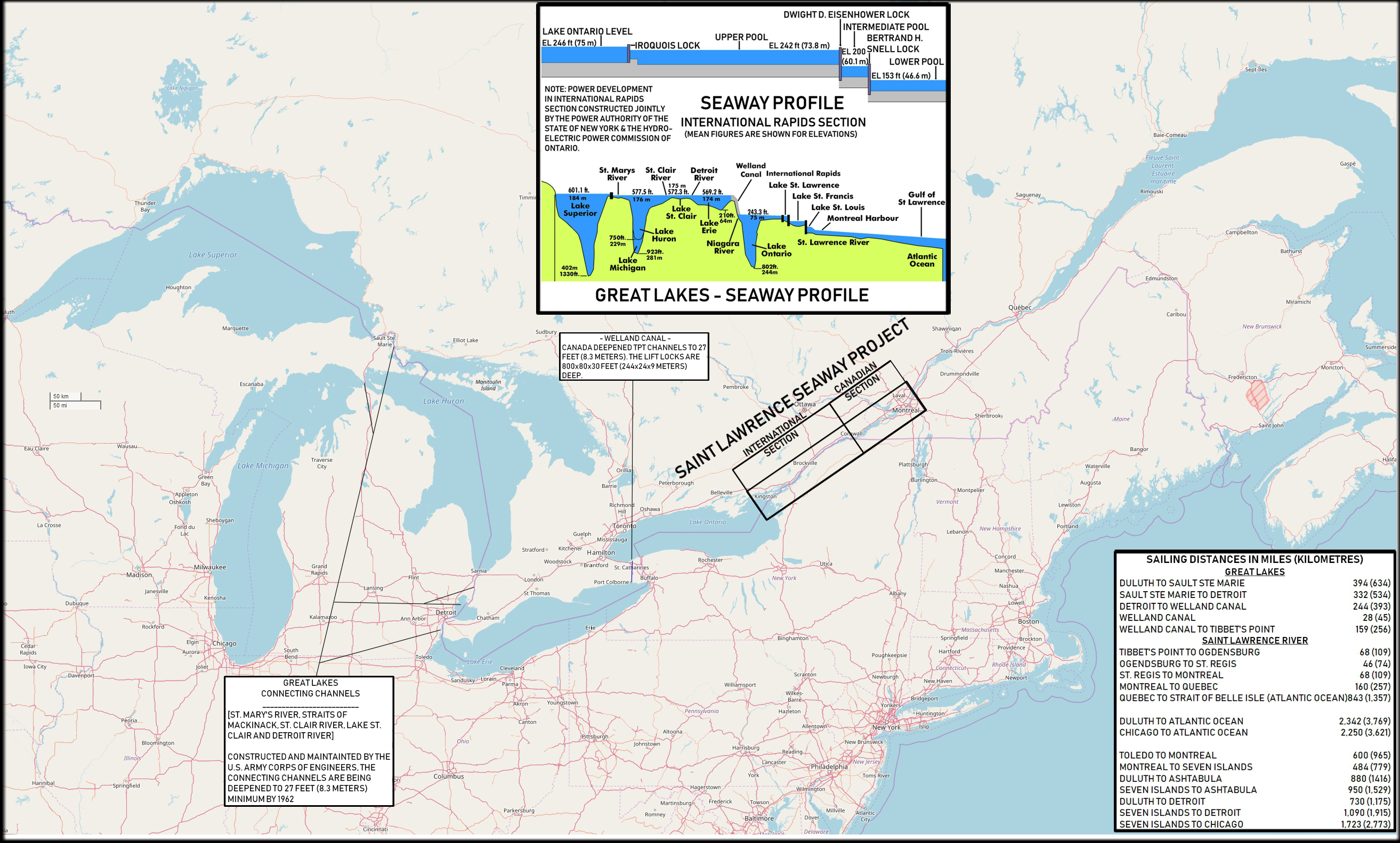
Size of this preview: 800 × 482 pixels. Other resolutions: 320 × 193 pixels | 640 × 386 pixels | 1,024 × 617 pixels | 1,280 × 771 pixels | 2,627 × 1,583 pixels.
Original file (2,627 × 1,583 pixels, file size: 3.63 MB, MIME type: image/png)
This is a file from the Wikimedia Commons and may be used by other projects. Information from its description page there is shown below. Commons is a freely licensed media file repository. |
Summary
| Description | Map of the North American Great Lakes and the St. Lawrence Seaway. |
| Date | 2018-02-25, original map from 1959 |
| Source | Based on: U.S. Navy All Hands magazine September 1959, p. 9. Also used and partly incorporated were File:Great Lakes 2.PNG and File:Water transport lock horizontal and sectional drawing.png. Map from openstreetmap.org. |
| Author | Cobatfor |
Licensing
I, the copyright holder of this work, hereby publish it under the following licenses:
This file is licensed under the Creative Commons Attribution-Share Alike 3.0 Unported license.
- You are free:
- to share – to copy, distribute and transmit the work
- to remix – to adapt the work
- Under the following conditions:
- attribution – You must give appropriate credit, provide a link to the license, and indicate if changes were made. You may do so in any reasonable manner, but not in any way that suggests the licensor endorses you or your use.
- share alike – If you remix, transform, or build upon the material, you must distribute your contributions under the same or compatible license as the original.
 | Permission is granted to copy, distribute and/or modify this document under the terms of the GNU Free Documentation License, Version 1.2 or any later version published by the Free Software Foundation; with no Invariant Sections, no Front-Cover Texts, and no Back-Cover Texts. A copy of the license is included in the section entitled GNU Free Documentation License. |
You may select the license of your choice.
File history
Click on a date/time to view the file as it appeared at that time.
| Date/Time | Thumbnail | Dimensions | User | Comment | |
|---|---|---|---|---|---|
| current | 17:18, 25 February 2018 | | 2,627 × 1,583 (3.63 MB) | Cobatfor | self-made version, metric measurements added |
| 10:22, 10 May 2014 | No thumbnail | 1,423 × 944 (702 KB) | Cobatfor | == {{int:filedesc}} == {{Information |Description=Map of the North American Great Lakes and the St. Lawrence Seaway. |Source=[http://www.navy.mil/ah_online/department_arch.html U.S. Navy All Hands magazine] [http://www.navy.mil/ah_online/archpdf/ah1959... |
File usage
There are no pages that use this file.
Global file usage
The following other wikis use this file:
- Usage on ar.wikipedia.org
- Usage on ast.wikipedia.org
- Usage on en.wikipedia.org
- Usage on es.wikipedia.org
- Usage on ja.wikipedia.org
- Usage on nl.wikipedia.org
- Usage on pt.wikipedia.org
Metadata
Explore the world

United states
New York

Japan
Tokyo

Singapore
Singapore
