
 Français
 Italiano
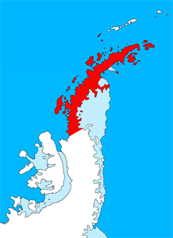
No higher resolution available.
GrahamLandstubmap.png (243 × 334 pixels, file size: 30 KB, MIME type: image/png)
This is a file from the Wikimedia Commons and may be used by other projects. Information from its description page there is shown below. Commons is a freely licensed media file repository. |
Summary
| Description | English: Outline map of the Antarctic Peninsula showing Graham Land. Drawn by me (User:Grutness) based on File:Ant-pen_map.png by Giovanni Fattori. |
| Date | 2 July 2011 (original upload date) |
| Source | Transferred from en.wikipedia to Commons. |
| Author | The original uploader was Grutness at English Wikipedia. |
Licensing
 | Permission is granted to copy, distribute and/or modify this document under the terms of the GNU Free Documentation License, Version 1.2 or any later version published by the Free Software Foundation; with no Invariant Sections, no Front-Cover Texts, and no Back-Cover Texts. A copy of the license is included in the section entitled GNU Free Documentation License. |
Original upload log
The original description page was here. All following user names refer to en.wikipedia.
- 2011-07-02 09:38 Grutness 243×334× (30925 bytes) Outline map of the Antarctic Peninsula showing [[Graham Land]]. Drawn by me (User:Grutness) based on [[:File:Ant-pen_map.png]] by Giovanni Fattori.{{GFDL}}
File history
Click on a date/time to view the file as it appeared at that time.
| Date/Time | Thumbnail | Dimensions | User | Comment | |
|---|---|---|---|---|---|
| current | 20:06, 9 July 2011 | | 243 × 334 (30 KB) | MGA73bot2 | {{BotMoveToCommons|en.wikipedia|year={{subst:CURRENTYEAR}}|month={{subst:CURRENTMONTHNAME}}|day={{subst:CURRENTDAY}}}} {{Information |Description={{en|Outline map of the Antarctic Peninsula showing en:Graham Land. Drawn by me (User:Grutness) base |
File usage
There are no pages that use this file.
Global file usage
The following other wikis use this file:
- Usage on az.wikipedia.org
- Usage on bg.wikipedia.org
- Usage on cs.wikipedia.org
- Usage on da.wikipedia.org
- Usage on de.wikipedia.org
- Usage on en.wikipedia.org
- Graham Land
- Mount Scott (Antarctica)
- Bowman Coast
- Cuverville Island
- Danco Island
- Charlotte Bay
- Loubet Coast
- Mill Inlet
- Cabinet Inlet
- Cape Alexander
- Cole Peninsula
- Castle Peak (Antarctica)
- Quartermain Glacier
- Quervain Peak
- Aagaard Glacier
- Bigourdan Fjord
- Cape Jeremy
- Weertman Island
- Bennett Islands
- Liard Island
- Devil Island
- Upper Island
- Useful Island
- Mount Zdarsky
- Mount Shackleton
- Shag Rock (Antarctica)
- Shanty Point
- Sharp Glacier
- Mount Shelby
- Mount St. Louis
- Shull Rocks
- Simler Snowfield
- Zilva Peaks
- Saffery Islands
- Index Peak
- Foyn Point
- Haefeli Glacier
- Finsterwalder Glacier
View more global usage of this file.
Explore the world

United states
New York

Japan
Tokyo

Singapore
Singapore
