
 Français
 Italiano
This is a file from the Wikimedia Commons and may be used by other projects. Information from its description page there is shown below. Commons is a freely licensed media file repository. |
Summary
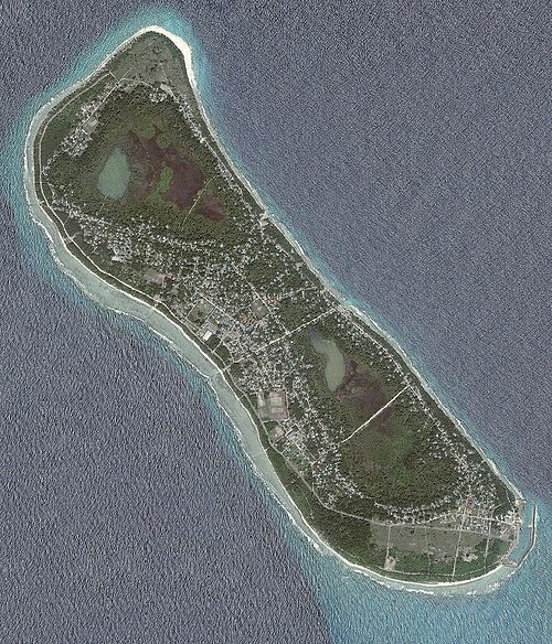
| Description | A satellite image of Fuvahmulah by Department of National Planning, Maldives. The labels on the image have been removed with some edits. |
| Date | 06/04/10 |
| Source | http://planning.gov.mv/atlas/satellite/V14AB/images/DNP_05_14AB_19Gn_Fuvahmulah.jpg |
| Author | GIS & Mapping Unit, Spatial Planning Section, Department of National Planning, Republic of Maldives |
| Permission (Reusing this file) | It was this year (2010) only that a copyright law was passed in the Maldives. It was in October 2010 that the law was put into effect. According to Article 36 of the copyright law of Maldives any products such as photos and on published in websites before the copyright law was put into effect are not protected under the copyright law. This applies to photos copied from original sources and published in other websites too according to the law. This photograph which was uploaded to Wikipedia much before that and was published in the aforesaid website even much before that it has no copyright protection. It has to be highlighted that the image was published in Wikipedia much before the law was passed or even presented to the Parliament while the law now states that it applies only to every photograph published after the law will be put into effect. So there is no way that this image can't be published in Wikipedia. See this link for the proof from the law: http://www.majlis.gov.mv/di/download/2010-thinvana-dhauruge-bill/copy%20rite.pdf This work is in the public domain in the United States because it is a work published in the Maldives before October 2010, which had no copyright law or intellectual property relations before this date , under the terms of Title 17, Section 104 of the US Code and Circ. 38a. |
| Other versions | http://isles.egov.mv/images/islands/DNP_05_14AB_19Gn_Fuvahmulah.jpg |
Licensing
- You are free:
- to share – to copy, distribute and transmit the work
- to remix – to adapt the work
- Under the following conditions:
- attribution – You must give appropriate credit, provide a link to the license, and indicate if changes were made. You may do so in any reasonable manner, but not in any way that suggests the licensor endorses you or your use.
- share alike – If you remix, transform, or build upon the material, you must distribute your contributions under the same or compatible license as the original.
This work is in the public domain in the United States because it is a work published in the Maldives before October 2010, which had no copyright law or intellectual property relations before this date , under the terms of Title 17, Section 104 of the US Code and Circ. 38a According to Article 36 of the copyright law in Maldives there is no copyright protection to this kind of images before October 2010.
File history
Click on a date/time to view the file as it appeared at that time.
| Date/Time | Thumbnail | Dimensions | User | Comment | |
|---|---|---|---|---|---|
| current | 15:16, 6 April 2010 | | 770 × 900 (289 KB) | Nxxxn | {{Information |Description=A satellite image of Fuvahmulah by Department of National Planning, Maldives. The labels on the image have been removed with some edits. |Source=http://planning.gov.mv/atlas/satellite/V14AB/images/DNP_05_14AB_19Gn_Fuvahmulah.jpg |
File usage
The following page uses this file:
Global file usage
The following other wikis use this file:
- Usage on ar.wikipedia.org
- Usage on arz.wikipedia.org
- Usage on ceb.wikipedia.org
- Usage on de.wikipedia.org
- Usage on dv.wikipedia.org
- Usage on en.wikipedia.org
- Usage on eo.wikipedia.org
- Usage on es.wikipedia.org
- Usage on fa.wikipedia.org
- Usage on he.wikipedia.org
- Usage on he.wikivoyage.org
- Usage on ka.wikipedia.org
- Usage on nl.wikipedia.org
- Usage on pl.wikipedia.org
- Usage on pt.wikivoyage.org
- Usage on sv.wikipedia.org
- Usage on www.wikidata.org
Metadata
Explore the world

United states
New York

Japan
Tokyo

Singapore
Singapore
