
 Français
 Italiano
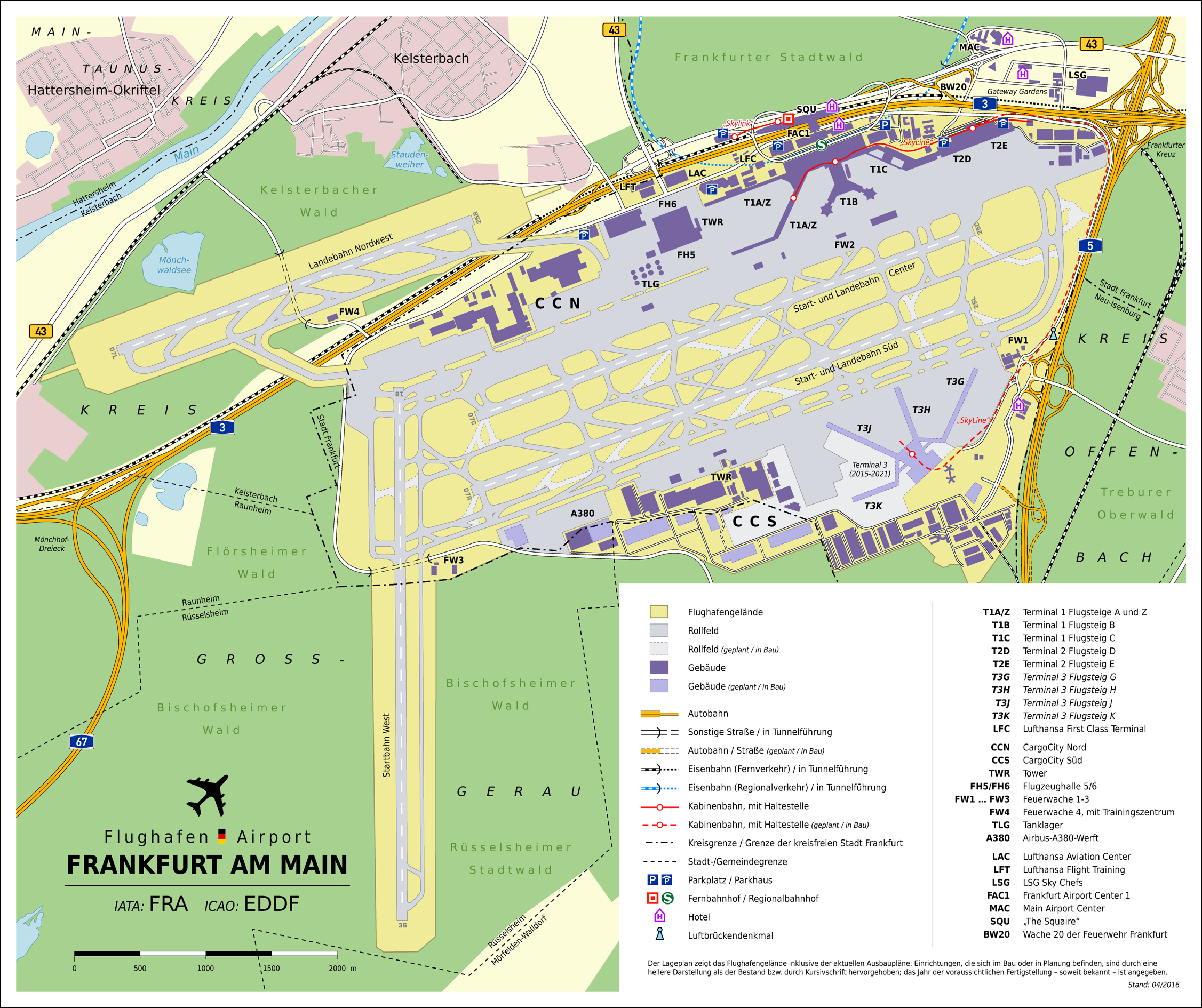
Size of this preview: 715 × 600 pixels. Other resolutions: 286 × 240 pixels | 572 × 480 pixels | 916 × 768 pixels | 1,221 × 1,024 pixels | 2,253 × 1,890 pixels.
Original file (2,253 × 1,890 pixels, file size: 1.53 MB, MIME type: image/png)
This is a file from the Wikimedia Commons and may be used by other projects. Information from its description page there is shown below. Commons is a freely licensed media file repository. |
Summary
| Description | Deutsch: Lageplan des Flughafen Frankfurt am Main (DE) | |||||||||
| Date | ||||||||||
| Source | Own work
| |||||||||
| Creator | ||||||||||
| Geotemporal data | ||||||||||
| Bounding box |
| |||||||||
| Georeferencing | ||||||||||
| Other versions |  | |||||||||
 | This architecture image could be re-created using vector graphics as an SVG file. This has several advantages; see Commons:Media for cleanup for more information. If an SVG form of this image is available, please upload it and afterwards replace this template with {{vector version available|new image name}}.It is recommended to name the SVG file “Frankfurt-Main Airport Map DE.svg”—then the template Vector version available (or Vva) does not need the new image name parameter. |
| Object location | | View this and other nearby images on: OpenStreetMap |
|---|
 | This map has been made or improved in the German Kartenwerkstatt (Map Lab). You can propose maps to improve as well. |
Licensing
This file is licensed under the Creative Commons Attribution-Share Alike 2.0 Generic license.
Attribution: Thomas Römer/OpenStreetMap data
- You are free:
- to share – to copy, distribute and transmit the work
- to remix – to adapt the work
- Under the following conditions:
- attribution – You must give appropriate credit, provide a link to the license, and indicate if changes were made. You may do so in any reasonable manner, but not in any way that suggests the licensor endorses you or your use.
- share alike – If you remix, transform, or build upon the material, you must distribute your contributions under the same or compatible license as the original.
File history
Click on a date/time to view the file as it appeared at that time.
| Date/Time | Thumbnail | Dimensions | User | Comment | |
|---|---|---|---|---|---|
| current | 19:48, 30 April 2016 | | 2,253 × 1,890 (1.53 MB) | Thoroe | optipng |
| 19:43, 30 April 2016 |  | 2,253 × 1,890 (2.03 MB) | Thoroe | upd | |
| 22:05, 14 May 2014 |  | 1,623 × 1,361 (1.06 MB) | Kopiersperre | optipng | |
| 11:09, 28 April 2012 |  | 1,623 × 1,361 (1.39 MB) | Thoroe | Parkhaus am "The Squaire" | |
| 16:00, 18 October 2011 |  | 1,623 × 1,361 (1.39 MB) | Thoroe | Startbahn Nordwest fertiggestellt | |
| 22:27, 18 August 2010 |  | 1,623 × 1,361 (1.39 MB) | Thoroe | Grenzen, Luftbrückendenkmal, Maßstabsleiste | |
| 13:01, 15 August 2010 |  | 1,623 × 1,361 (1.29 MB) | Thoroe | Hotel-Piktogramm, Feuerwache 4, SkyLine-Haltestellen, Textänderungen | |
| 02:38, 15 August 2010 |  | 1,623 × 1,361 (1.28 MB) | Thoroe | {{Information |Description={{en|1=Map of Frankfurt Airport, Germany}} {{de|1=Lageplan des Flughafen Frankfurt am Main}} |Source={{own}}{{Adobe Illustrator}} *[http://www.openstr |
File usage
There are no pages that use this file.
Global file usage
The following other wikis use this file:
- Usage on cs.wikipedia.org
- Usage on de.wikipedia.org
- SkyLine
- Vorlage Diskussion:Infobox Flughafen
- Liste der größten Verkehrsflughäfen
- Flughafen Frankfurt Main
- Flughafenfeuerwehr Frankfurt am Main
- Diskussion:Flughafenfeuerwehr Frankfurt am Main
- Rollbahnbrücke (Flughafen Frankfurt Main)
- Benutzer:Thoroe
- Benutzer:KaterBegemot/Kartografen
- Wikipedia:Kartenwerkstatt/Archiv/2010-08
- Benutzer Diskussion:Thoroe/Archiv
- Wikipedia Diskussion:Kartenwerkstatt/Archiv6
- Wikipedia:Kartenwerkstatt/Karte des Tages/Galerie
- Wikipedia:Kartenwerkstatt/Archiv/2016-05
- Benutzer:Kpfiwa/Liste der größten Verkehrsflughäfen
- Usage on es.wikivoyage.org
- Usage on fr.wikipedia.org
- Usage on it.wikivoyage.org
- Usage on ja.wikipedia.org
- Usage on ja.wiktionary.org
- Usage on ko.wikipedia.org
- Usage on pt.wikipedia.org
- Usage on uk.wikipedia.org
- Usage on www.wikidata.org
Metadata
Explore the world

United states
New York

Japan
Tokyo

Singapore
Singapore
