
 Français
 Italiano
Original file (720 × 720 pixels, file size: 119 KB, MIME type: image/jpeg)
This is a file from the Wikimedia Commons and may be used by other projects. Information from its description page there is shown below. Commons is a freely licensed media file repository. |
Summary
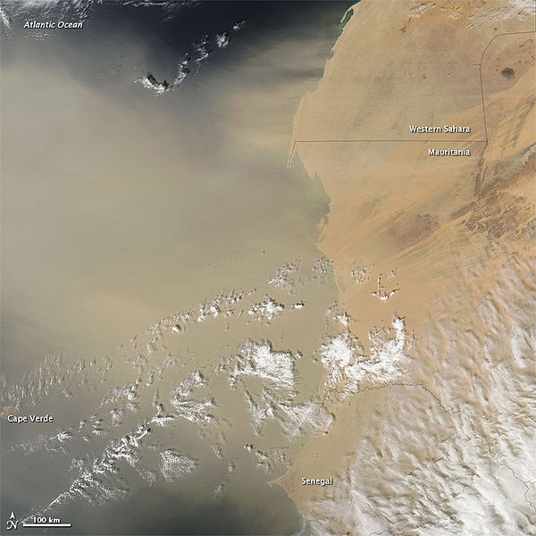
| Description | English: To download the full resolution and other files go to: earthobservatory.nasa.gov/NaturalHazards/view.php?id=7711... A dust plume spanning hundreds of kilometers blew off the coast of western Africa on February 6, 2012. The Moderate Resolution Imaging Spectroradiometer (MODIS) on NASA’s Aqua satellite took this picture the same day. West of Mauritania, the dust is thick enough to hide the ocean surface below. Part of the Cape Verde archipelago dimly shows through the plume. Clouds floating overhead cast their shadows on the dust. Distinct plumes blow off the coast of Western Sahara over the ocean, but the large veil of dust in the southwest likely arose farther inland. Sandy desert covers most of Mauritania, and those sand seas may have provided the material for most of the dust in this image. The clouds in the southeast are part of a large cloudbank stretching over western Africa. This large cloudbank could be associated with the weather pattern that blew the dust off the coast. NASA image courtesy Jeff Schmaltz, LANCE/EOSDIS MODIS Rapid Response Team at NASA GSFC. Caption by Michon Scott. The Earth Observatory's mission is to share with the public the images, stories, and discoveries about climate and the environment that emerge from NASA research, including its satellite missions, in-the-field research, and climate models. |
| Date | |
| Source | Dust off Western Africa |
| Author | NASA's Earth Observatory |
| Camera location | | View this and other nearby images on: OpenStreetMap |
|---|
Licensing
- You are free:
- to share – to copy, distribute and transmit the work
- to remix – to adapt the work
- Under the following conditions:
- attribution – You must give appropriate credit, provide a link to the license, and indicate if changes were made. You may do so in any reasonable manner, but not in any way that suggests the licensor endorses you or your use.
| This image was originally posted to Flickr by NASA Earth Observatory at https://www.flickr.com/photos/68824346@N02/6842189405. It was reviewed on 2 July 2012 by FlickreviewR and was confirmed to be licensed under the terms of the cc-by-2.0. |
File history
Click on a date/time to view the file as it appeared at that time.
| Date/Time | Thumbnail | Dimensions | User | Comment | |
|---|---|---|---|---|---|
| current | 17:10, 2 July 2012 | | 720 × 720 (119 KB) | Dzlinker | == {{int:filedesc}} == {{Information |Description=To download the full resolution and other files go to: [http://earthobservatory.nasa.gov/NaturalHazards/view.php?id=77110&src=flickr earthobservatory.nasa.gov/NaturalHazards/view.php?id=7711...] A dust... |
File usage
The following page uses this file:
Metadata
Explore the world

United states
New York

Japan
Tokyo

Singapore
Singapore
